Mas-de-Londres
| Mas-de-Londres | |
|---|---|
|
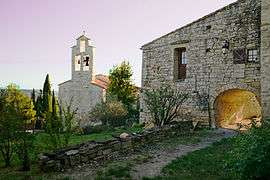
The church of Saint-Gérard | |
 Mas-de-Londres | |
|
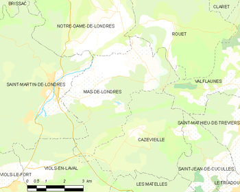
Location within Occitanie region  Mas-de-Londres | |
| Coordinates: 43°46′56″N 3°45′12″E / 43.7822°N 3.7533°ECoordinates: 43°46′56″N 3°45′12″E / 43.7822°N 3.7533°E | |
| Country | France |
| Region | Occitanie |
| Department | Hérault |
| Arrondissement | Lodève |
| Canton | Saint-Martin-de-Londres |
| Intercommunality | Séranne-Pic Saint-Loup |
| Government | |
| • Mayor (2008–2014) | Patrice Colin |
| Area1 | 19.06 km2 (7.36 sq mi) |
| Population (2008)2 | 381 |
| • Density | 20/km2 (52/sq mi) |
| Time zone | CET (UTC+1) |
| • Summer (DST) | CEST (UTC+2) |
| INSEE/Postal code | 34152 / 34380 |
| Elevation |
167–400 m (548–1,312 ft) (avg. 201 m or 659 ft) |
|
1 French Land Register data, which excludes lakes, ponds, glaciers > 1 km² (0.386 sq mi or 247 acres) and river estuaries. 2 Population without double counting: residents of multiple communes (e.g., students and military personnel) only counted once. | |
Mas-de-Londres is a commune in the Hérault department in southern France.
Map
Population
| Historical population | ||
|---|---|---|
| Year | Pop. | ±% |
| 1962 | 126 | — |
| 1968 | 129 | +2.4% |
| 1975 | 120 | −7.0% |
| 1982 | 183 | +52.5% |
| 1990 | 204 | +11.5% |
| 1999 | 275 | +34.8% |
| 2008 | 381 | +38.5% |
See also
References
| Wikimedia Commons has media related to Mas-de-Londres. |
This article is issued from Wikipedia - version of the 6/28/2015. The text is available under the Creative Commons Attribution/Share Alike but additional terms may apply for the media files.