Marysville, Ohio
| Marysville, Ohio | |
|---|---|
| City | |
|
Intersection of State Routes 31 and 38 in Marysville | |
| Nickname(s): The Shaded City | |
 Location in the state of Ohio, United States | |
 Location of Marysville in Union County | |
| Coordinates: 40°14′02″N 83°21′59″W / 40.23389°N 83.36639°WCoordinates: 40°14′02″N 83°21′59″W / 40.23389°N 83.36639°W | |
| Country | United States |
| State | Ohio |
| County | Union |
| Government | |
| • Type | Mayor-Council |
| • Mayor | John Gore |
| Area[1] | |
| • City | 16.56 sq mi (42.89 km2) |
| • Land | 16.27 sq mi (42.14 km2) |
| • Water | 0.29 sq mi (0.75 km2) |
| Elevation | 991 ft (302 m) |
| Population (2010)[2] | |
| • City | 22,094 |
| • Estimate (2012[3]) | 22,051 |
| • Density | 1,358.0/sq mi (524.3/km2) |
| • Urban | 22,094 |
| Time zone | EST (UTC-5) |
| • Summer (DST) | EDT (UTC-4) |
| ZIP codes | 43040-43041 |
| Area code(s) | 937 |
| FIPS code | 39-48160[4] |
| GNIS feature ID | 1061480[5] |
| Website | http://www.marysvilleohio.org/ |

Marysville is a town in and the county seat of Union County, Ohio, United States.[6] The population was 22,094 at the 2010 census. This marks a 38.59% increase from 2000.[7]
Marysville's longtime slogan is "Where the Grass is Greener".[8]
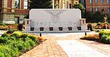
In December 2008, Marysville was designated as a "Preserve America Community" by the First Lady Laura Bush.[9]
History
Origins
Marysville was originally part of Northwest Territory, and then became part of the Virginia Military District within that territory, and eventually became part of the state of Ohio. One of the original surveyors of the area was James Galloway, Jr., who first visited in 1805.[10] Marysville was founded in 1819 by Samuel W. Cuthbertson, who named the town after his daughter Mary,[11] along the small waterway of Mill Creek.
County seat designation
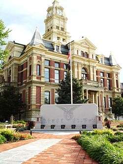
After the organization of the county by the Ohio Legislature, Marysville was designated as the seat of Union County.[12] The first recorded meeting of the commissioners was in 1820.[13] Between 1835 and 1840, a courthouse was constructed.[14] Eventually, a new dedicated courthouse would be built in Marysville on January 27, 1883, which is also presently in use.[15]
In 1849, a county infirmary was authorized. The first county jail was a log structure that sat on the south side of East Center street, in the rear of the courthouse. Eventually a new jail was authorized by the commissioners and built in the 1870s. In 1878 the county purchased a 10-ton safe for the treasury, that eventually was moved into courthouse.[16]
The first county fair was held in 1847 in Marysville, in the public square. In 1852, the Agriculture Society moved the fair to the current location, on the north side of town.[17]
Early development
Marysville was originally laid out in 1820. The first permanent settlement was made by Abraham Amrine, of Swiss descent, in 1817, two miles north of the city.[18] Today the main road leading to the high school is named Amrine-Mill Rd.
In 1824, the first post office was established. At this time, there were only four families in the village.[19] In 1828, Marysville's first school was established in the east side of town using a log cabin as its building structure. By 1839, there were already three schools operating in the town. In 1843, the first high school was opened by Caroline Humphrey, and by 1850 there was a Board of Education making annual reports to the voters.[20]
In 1837, the Ohio Gazetteer published that Marysville was a small post town consisting of a court house, a jail, forty-five dwelling houses, one tavern, three stores, one practicing physician, two attorneys and about 250 inhabitants.[21] By 1846, Marysville had 360 inhabitants, three small dry goods stores, two churches (Presbyterian and Methodist), a private school, and a newspaper office.[22]
Early Marysville businesses during this period included McClouds Drug Store on the south side of the square, the Cheap Cash Store, the American Hotel, the W.W. Woods store, and Hare and Hughes, a hat business located on the southwest corner of the square. Several locals ran personal unnamed businesses. The village was incorporated in 1840, with Otway Curry elected as the first mayor.[23]
Ladders were first purchased for a fire department in 1845, and by 1865 the village had purchased the first fire engine. The commissioners petitioned for a fire house, but it would not be built until 1906, being a two level brick building.[24]
A census in 1859 showed that the village had 981 residents. By 1865, Marysville had six dry goods stores, one hardware store, nine or ten groceries, a mill, a woolen factory, and most of the trades and professions. It was growing steadily by this point.[25]
In 1877, the town council decided to build a city hall on the southeast corner of Main and South. It would be completed in 1878, and house the council rooms, public library, fire department rooms, and city prison.[26] An opera house would be constructed as well. In 1877, a fine building was erected on the eastside of town for education. It had ten rooms for educational purposes, other rooms for various purposes, and an exhibition hall on the upper floor. The Agassiz Scientific, Archaeological and Historical Society of Marysville was organized in 1879, and placed in the East school building, their museum was also placed in the same building.[27]
By 1888, Marysville had earned itself the title of “the Shaded City” because of its tree-lined streets, and by 1890, its population increased to 2,832 residents.[28]
Early manufacturing and banking
Marysville's industrial roots can be traced back to many early companies. Among those were the Marysville Pearlash Factory, an ashery founded in 1848, which by 1874 was the largest in the United States. The first steam-grist mill was erected in 1856 by Saxton and Casil. In 1867, Miller & Snodgrass constructed a flour mill. In 1874, Marysville Butter Tub and Spoke Company was incorporated with $50,000.[29]
A wool company, Woodbury & Welsh, constructed a factory out of brick in the northeast part of town in 1864, and a brewery was built in 1866 on the east side. In 1868, O.M. Scotts and Company was organized. In 1871, the Marysville Cheese Manufacturing Company was built on the east side. Many carriage manufacturing companies operated in Marysville, including Bauer, Schepper & Devine in 1882, City Carriage Works in 1871, and L. E. Helium in 1874.[30]
In 1875 Rice, Fleck & Co. opened a lumberyard. The Marysville Gas Light Company was incorporated in 1878 following almost a decade of the city using gasoline for lighting. The Bank of Marysville was opened in 1854, the Farmer's Bank of Union County in 1868 located on the southeast corner of the square, and the People's Bank in 1874.[31]
Early culture
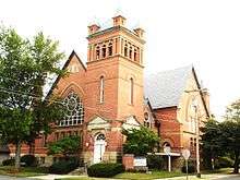
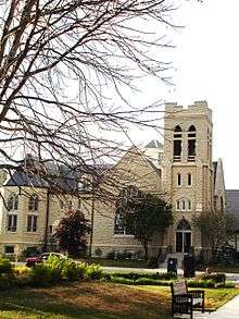
In 1827 the Methodist Episcopal Church was organized. In 1856 the church dedicated a new building on East Center street. The first 4 July celebrations were held in 1828.[32]
In 1840, Otway Curry, a poet of national fame and resident of Marysville, wrote the "Log Cabin Song." It would inspire the Log Cabin Campaign of William Henry Harrison, who would go on to win the Presidential election that year.[33]
The Presbyterian Church was organized in the house of Stephen McClain on September 9, 1829. In 1866, a movement was started to construct a new church building; a new building was finally dedicated in 1870, located at the corner of Center and West Streets. The Congregational Church organized in 1864, with a building constructed on the northeast corner of West and South Street.[34]
The Church of Our Lady of Lourdes, a Roman Catholic Church, was constructed in 1866 at Water Street near the railroad station. The German Lutheran Church organized in 1875, also operating their own school.[35]
Modern development

Over the next century, Marysville's population would double from its 1890 census. A new high school was built in the West neighborhood behind the courthouse, which would then become a middle school later when a new high school would be built on the north side. The most recent high school went up in the 1990s. At that time, the old high school became the new middle school, and the old middle school became county offices.
In 1948, Nestlé opened a research and development center in the West neighborhood. A new city hall would be constructed on the southeast side of Uptown, which housed the police department. Memorial Hospital of Union County located in the Medical district in 1952.[36] Many other developments took place during this time, including the construction of the Union County Airport on the east side in 1967,[37] as well as numerous manufacturing companies and small housing developments being constructed throughout the city. Timberview, an upscale residential section on the south side, would be constructed, and included a golf course. Greenwood Colony would also be built on the south side.
In 1977, Honda announced plans to construct a motorcycle assembly plant in Marysville[38] and eventually opened manufacturing plants on the far west side of the town in 1982. This caused the expansion of the U.S. Route 33.
President George H.W. Bush would visit in 1992 as part of his "whistle stop train tour" re-election campaign.[39]
Historic architecture of Marysville
 Frank Lloyd Wright prairie style, West
 Queen Anne style, West
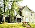 Victorian style, East
 Classical style, West
 Cape Cod style, West
 Dutch Colonial Revival Bungalow, East
 American Foursquare style, West
 French-influenced style, Edgewood
 Italianate Victorian style, East
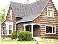 Shingle style, West
 Colonial style, West
 Italianate style, West(former home of U.S. Representative Cornelius Hamilton)
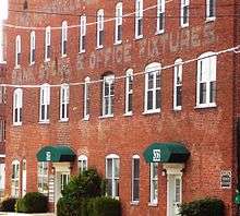
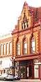 Liggett building, Uptown
Geography
According to the United States Census Bureau, the city has a total area of 16.56 square miles (42.89 km2), of which 16.27 square miles (42.14 km2) is land and 0.29 square miles (0.75 km2) is water.[1]
Demographics
| Historical population | |||
|---|---|---|---|
| Census | Pop. | %± | |
| 1840 | 360 | — | |
| 1850 | 605 | 68.1% | |
| 1860 | 849 | 40.3% | |
| 1870 | 1,441 | 69.7% | |
| 1880 | 2,061 | 43.0% | |
| 1890 | 2,810 | 36.3% | |
| 1900 | 3,048 | 8.5% | |
| 1910 | 3,576 | 17.3% | |
| 1920 | 3,035 | −15.1% | |
| 1930 | 3,639 | 19.9% | |
| 1940 | 4,037 | 10.9% | |
| 1950 | 4,256 | 5.4% | |
| 1960 | 4,952 | 16.4% | |
| 1970 | 5,744 | 16.0% | |
| 1980 | 7,403 | 28.9% | |
| 1990 | 9,656 | 30.4% | |
| 2000 | 15,942 | 65.1% | |
| 2010 | 22,094 | 38.6% | |
| Est. 2015 | 22,817 | [40] | 3.3% |
| Sources:[4][41][42][43][44][45][46][47] | |||
As of 2000 the median income for a household in the city was $55,671. Males had a median income of $40,973 versus $27,427 for females. The per capita income for the city was $22,812. About 4.0% of families and 5.7% of the population were below the poverty line, including 5.3% of those under age 18 and 9.4% of those age 65 or over.
The median price for a home in Marysville was $168,100 according to Census 2010.[48]
2010 census
As of the census[2] of 2010, there were 22,094 people, 7,314 households, and 5,050 families residing in the city. The population density was 1,358.0 inhabitants per square mile (524.3/km2). There were 7,969 housing units at an average density of 489.8 per square mile (189.1/km2). The racial makeup of the city was 90.4% White, 4.5% African American, 0.3% Native American, 2.3% Asian, 0.1% Pacific Islander, 0.6% from other races, and 1.8% from two or more races. Hispanic or Latino of any race were 1.8% of the population.
There were 7,314 households of which 41.7% had children under the age of 18 living with them, 53.1% were married couples living together, 11.6% had a female householder with no husband present, 4.4% had a male householder with no wife present, and 31.0% were non-families. 25.2% of all households were made up of individuals and 8.1% had someone living alone who was 65 years of age or older. The average household size was 2.62 and the average family size was 3.16.
The median age in the city was 33.1 years. 26.6% of residents were under the age of 18; 8.6% were between the ages of 18 and 24; 36.1% were from 25 to 44; 20.7% were from 45 to 64; and 8.1% were 65 years of age or older. The gender makeup of the city was 42.8% male and 57.2% female.
Economy

Industrial and manufacturing


Marysville is the headquarters for Scotts Miracle-Gro Company, the largest producer in the world of horticulture products. The company was founded in 1868 by Orlando Scott in Marysville, and has grown to have an $8 billion market.[49]
Two Honda Motors plants are located in Marysville. The first production facilities opened by Honda in the United States were the Marysville Motorcycle Plant (1979) and the Marysville Auto Plant (1982), located about six miles (10 km) northwest of the city. The Marysville Auto Plant has been the leading producer of the Honda Accord since 1982.[50]
Marysville is also home to the corporate headquarters of Univenture, which manufactures and markets media packaging and a Parker Hannifin (formerly Denison Hydraulics) manufacturing facility. There is a regional Goodyear manufacturing facility, under the name of Veyance Technologies also located within city limits.
Research and development

Marysville is home to several research and development operations. Nestlé, located on the west side of the city, has a Product Technology Center dedicated to ready-to-drink mixes.[51] Scotts Miracle Gro also has their R&D operations located on their corporate campus on the eastside. The Transportation Research Center, a state-of-the-art facility dedicated to transportation research, is located a few miles from Marysville in East Liberty near the Honda manufacturing campus. A unit of Univenture, Algae Venture Systems, recently made a breakthrough by developing a process to produce algae as a cost-effective biofuel.[52]
Agriculture
The Marysville area is home to major agricultural operations. Several egg products manufacturers are located in the rural stretches around Marysville. Select Sires is a major biotech firm, specializing is animal reproduction services, which is located a few miles from Marysville. Many local, family operated farms surround the Marysville area. The Ohio State University operates an agricultural extension office in the northern part of the city.
Education
Marysville is part of the Marysville Exempted Village Schools District.
Besides the Marysville Exempted Village School district, there are other opportunities for education as well. The local church-affiliated St. John’s Lutheran School[53] and Trinity Lutheran School[54] both have curricula for students up through the middle school level, and the LEADS Head Start program is a preschool and childhood development program which, in their own words, “serves income eligible families with children ages three and four, including children with special needs.”[55]
Schools of Marysville
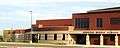 Bunsold Middle School, southern Union County
 Marysville High School, Academic district
 Marysville Middle School, Academic district
 Trinity Lutheran parochial school, East
Infrastructure
Transportation
Airport
The Union County Airport is located in Marysville. It sports a 4,220-foot (1,290 m) runway, complete passenger and freight air service, and can accommodate private and/or executive aircraft.
U.S. 33
U.S. Route 33 is a four-lane controlled-access highway that runs through Marysville, connecting the city with major highways including Interstate 75 to the northwest, and the I-270 outerbelt to the southeast, which links with Interstates 70 and 71 in Columbus. Rt. 33 is considered one of the major transportation arteries in Ohio.
Intermodal railyard
The city a rejected a proposal to locate an intermodal railyard within the city limits, which would have provided the city with a regional county transportation hub.
Utilities
Water and sewer
The City opened new sewer facilities and a water reservoir in 2009. Union county is currently the third fastest growing county in the state of Ohio.[56]
Inflatable dam technology
In 2009, Marysville became the first city in Central Ohio to employ the use of inflatable dam technology, which was built on Mill Creek. The dam is part of the new water reservoir system.[57]
Energy
The city of Marysville is serviced by Dayton Power and Light, with the surrounding area also served, depending on location, by Union Rural Electric and AEP Ohio.
State prison
Marysville is home to Ohio Reformatory for Women.
Healthcare

Marysville is home to numerous physicians' offices, and Memorial Health. The hospital recently underwent a multimillion-dollar renovation, bringing it into the modern era. Currently it is a 107-bed building, with a primary and emergency care center, and numerous other services including laboratory and imaging services. They also have long-term nursing care and an occupational health center.[36]
In 2009, Memorial was named as one of the nation's most technologically improved centers by Health & Hospitals Network magazine.[58] The Ohio State University Heart Center opened there in 2009. In 2014, Memorial opened the City Gate Medical Center located at 120 Coleman's Crossing Blvd. which houses sports medicine, physical therapy, orthopedics and sports medicine, urgent care and an imaging location.[59] Marysville is home to several Chiropractic offices. Moving to the area in 2011 was Central Ohio Clinic of Chiropractic and Dr. Brett J. Blitzstein, Chiropractor and founder and developer of JMR, Joint and Muscle Restoration technique.
Media
The Marysville Journal-Tribune is the oldest newspaper establishment in the city, dating back to 1849. The Gaumer-Behrens family has owned the newspaper since 1904. Their electronic version has been awarded the "Best Website In The State Award" by the Associated Press.[60]
Marysville recently voted the Kelly Rippa vehicle "Hope & Faith" as the official TV show of the city. The complete series DVD collection has been entombed beneath the Plain City Historical Society Museum.[61]
Parks, fitness, and leisure
The Marysville area is host to a wide variety of parks, fitness, and leisure activities.
Parks and leisure


There are numerous parks, totaling over 300 acres (1.2 km2). They include such features as walking and bike nature trails along Mill Creek, with trails at Aldersgate, Eljers, McCarthy, Mill Creek, Mill Valley South and Central, and Shwartzkopf parks. There is an amphitheater at the American Legion park, soccer and baseball fields at Eljer, Lewis, Mill Creek, and Mill Valley South and Central parks, lighted tennis courts at Eljer and Lewis parks, basketball courts at the American Legion and Aldersgate park with lighted courts at Eljer and Lewis parks, and a football field at Lewis park. There is fishing at Aldersgate, McCarthy, Mill Creek, Mill Valley Central, and Shwartzkopf parks. There is a nature preserve at MacIvor Woods. There is a Frisbee golf course, and a skateboard park at Eljer Park.
There are several horse farms and equine centers located in the Marysville area, as are several local golf clubs. The Piatt Castles, Covered Bridges of Union County, and the Big Darby Plains Scenic Byway are a short drive away.
The Scotts Miracle-Gro museum is located just south of the square in Uptown.
The Marysville Public Library is located on Plum Street near Uptown.
Festivals
Marysville is also host to several local festivals and downtown events throughout the year,[62] such as:
- Taste of Marysville
- The Union County Fair (late July-early August)
- Friday Nights Uptown (1 monthly:May–June–July–August)
- Farmers Market Festival (August)
- The All Ohio Balloon Festival (third week Aug)
- Festifair (Saturday after Labor Day)
- Covered Bridge Festival (September)
- Legends of Marysville- Walking Tours (October)
- Uptown Christmas Walk & Tree Lighting
- Pediatric Brain Tumor Foundation Ride and Run for kids
Sister city
Notable people
- Robert S. Beightler — military general, engineer, businessman, and contributor to the modern Interstate Highway System and Ohio Turnpike
- Chase Blackburn — football player
- Arthur E. Drumm — industrialist, inventor, industrial broom pioneer
- Cornelia Cole Fairbanks — 2nd Lady of the United States, former President-General of the Daughters of the American Revolution
- Charles Coleman Finlay — science fiction and fantasy author
- James Hagedorn — Scotts Miracle-Gro CEO, co-Chairman of National Fund for the U.S. Botanic Garden, and Chairman of Farms for City Kids Foundation[64]
- Darren Hall — baseball player
- Cornelius S. Hamilton — United States Congressman
- John F. Kinney — jurist and politician
- Natalia Laschenova — former Soviet Latvian gymnast, 1988 Olympic gold medalist[65]
- Terry N. Phipps - poet and writer
- Preston B. Plumb — United States Senator
- James Wallace Robinson — United States Congressman
- Orlando Scott — founder of the O.M. Scott and Sons Company, later becoming the Scotts Miracle-Gro Company
- Gary Shirk — football player
- Thomas B. Ward — United States Congressman
References
- 1 2 "US Gazetteer files 2010". United States Census Bureau. Retrieved 2013-01-06.
- 1 2 "American FactFinder". United States Census Bureau. Retrieved 2013-01-06.
- ↑ "Population Estimates". United States Census Bureau. Retrieved 2013-06-17.
- 1 2 "American FactFinder". United States Census Bureau. Retrieved 2008-01-31.
- ↑ "US Board on Geographic Names". United States Geological Survey. 2007-10-25. Retrieved 2008-01-31.
- ↑ "Find a County". National Association of Counties. Retrieved 2011-06-07.
- ↑ "2006 US Census estimate". Factfinder.census.gov. Retrieved 2010-04-25.
- ↑ William Malic (13 March 2013). "The Journey - Bean Town to L.A.". Lulu Press, Inc. pp. Chapter 7. Retrieved 21 October 2015.
- ↑ Horns, Ryan (22 December 2008). "City receives special designation". Times-Journal. Marysville, OH. Retrieved 7 August 2013.
- ↑ Durant, Pliny (1883). The History of Union County, Ohio, containing a history of the county... Chicago, IL: W. H. Beers & Co. p. 274.
- ↑ Kilbourn, John (1833). "The Ohio Gazetteer, or, a Topographical Dictionary". Scott and Wright. p. 301. Retrieved 12 December 2013.
- ↑ Durant, p. 313
- ↑ Durant, pp. 342 & 347
- ↑ Durant, p. 318
- ↑ Durant, p. 319
- ↑ Durant, pp. 323-324
- ↑ Durant, p. 328
- ↑ Durant, "Township Histories- Chapter 1" p.64
- ↑ Durant, "Township Histories- Chapter 1", p.8
- ↑ History, Paris Township, p.43,44
- ↑ Durant, "Township Histories- Chapter 1", p.31
- ↑ Durant, p. 347
- ↑ Durant, "Township Histories- Chapter 1", pp.32 & 48
- ↑ Durant, "Township Histories- Chapter 1", p.53
- ↑ Durant, "Township Histories- Chapter 1", p.32
- ↑ Durant, "Township Histories- Chapter 1", p.54
- ↑ Durant, "Township Histories- Chapter 1", pp.47 & 62
- ↑ Durant, "Township Histories- Chapter 1"
- ↑ Durant, "Township Histories- Chapter 1", p.55
- ↑ Durant, "Township Histories- Chapter 1", p.56
- ↑ Durant, "Township Histories- Chapter 1", pp.56- 57
- ↑ Durant, "Township Histories- Chapter 1", pp.33-34
- ↑ Durant, p. 402
- ↑ Durant, "Township Histories- Chapter 1", p.35-41
- ↑ Durant, "Township Histories- Chapter 1", p.42
- 1 2 "History". Memorial Hospital of Union. Retrieved 7 August 2013.
- ↑ "Union County Airport, Marysville, OH". AirNav. Retrieved 7 August 2013.
- ↑ John P. Blair, Laura A. Reese (1999). "Approaches to Economic Development: Readings From Economic Development Quarterly". SAGE. p. 295. Retrieved 21 October 2015.
- ↑ Hess, David (27 September 1992). "Bush Spreads His Message On Ohio Whistle-stop Tour". Philadelphia Inquirer. Philadelphia, PA.
- ↑ "Annual Estimates of the Resident Population for Incorporated Places: April 1, 2010 to July 1, 2015". Retrieved July 2, 2016.
- ↑ "Population of Civil Divisions Less than Counties" (PDF). Statistics of the Population of the United States at the Tenth Census. U.S. Census Bureau. Retrieved 28 November 2013.
- ↑ "Population of Civil Divisions Less than Counties" (PDF). Statistics of the Population of the United States at the Tenth Census. U.S. Census Bureau. Retrieved 28 November 2013.
- ↑ "Population: Ohio" (PDF). 1910 U.S. Census. U.S. Census Bureau. Retrieved 28 November 2013.
- ↑ "Population: Ohio" (PDF). 1930 US Census. U.S. Census Bureau. Retrieved 28 November 2013.
- ↑ "Number of Inhabitants: Ohio" (PDF). 18th Census of the United States. U.S. Census Bureau. Retrieved 22 November 2013.
- ↑ "Ohio: Population and Housing Unit Counts" (PDF). U.S. Census Bureau. Retrieved 22 November 2013.
- ↑ "Incorporated Places and Minor Civil Divisions Datasets: Subcounty Population Estimates: April 1, 2010 to July 1, 2012". U.S. Census Bureau. Retrieved 25 November 2013.
- ↑ City Data
- ↑ "Company". The Scott Miracle-Gro Company. Retrieved 7 August 2013.
- ↑ "Honda's Marysville Auto Plant at 25 Years: Historic Yet 'New'". American Honda Motor Co. 21 August 2007. Retrieved 7 August 2013.
- ↑ "Our Global Network". Nestlé. Retrieved 7 August 2013.
- ↑ Kessler, Richard A. (21 December 2012). "Univenture claims algae-to-fuel breakthrough". Recharge News. Retrieved 22 September 2009.
- ↑ "St. John's Lutheran School, Marysville".
- ↑ "Trinity Lutheran School".
- ↑ "LEADS Community Action Agency home page".
- ↑ "History of Union County".
- ↑ Ball, Brian R. (10 August 2009). "Inflatable dam technology makes way to Central Ohio". Columbus Business First. Retrieved 16 September 2009.
- ↑ "Most improved". HHN Magazine. Retrieved August 29, 2009.
- ↑ http://www.memorialohio.com/citygate
- ↑ "Journal Tribune Earns Honors". Marysvillejt.com. 2008-04-28. Retrieved 2010-04-25.
- ↑ "Hope & Faith". 26 September 2003 – via IMDb.
- ↑ "Marysville, OH Profile on Epodunk.com".
- ↑ "Marysville seeks to deepen links to Japan".
- ↑ Bounds, Gwendolyn (2009-08-19). "The Cutting Edge of Green Lawn-Care Products". online.wsj.com. Retrieved 2010-04-25.
- ↑ Phillips, Jeb (2010-03-16). "Former Soviet Olympian tries to stay here after visa expires". The Columbus Dispatch. Retrieved 2010-04-25.
External links
| Wikimedia Commons has media related to Marysville, Ohio. |
- City of Marysville
- Union County Chamber of Commerce
- Ohio Historical Society
- Marysville Journal Tribune
Municipalities and communities of Union County, Ohio, United States | ||
|---|---|---|
| Cities | 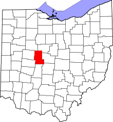 | |
| Villages | ||
| Townships | ||
| CDPs | ||
| Unincorporated communities | ||
| Ghost town | ||
| Footnotes | ‡This populated place also has portions in an adjacent county or counties | |