Neighborhoods in Portland, Maine
Portland, Maine is home to many neighborhoods.[1]
Arts District
Portland's Arts District is based around Congress Street in downtown Portland. The District includes the Portland Museum of Art, the Children's Museum of Maine, the Maine College of Art (MECA) and the State Theatre. It is a mixed use neighborhood with both apartments and commercial establishments.[2]
Back Cove
Back Cove is a neighborhood off of Portland's peninsula and downtown areas. With views of the Portland skyline across Back Cove, it borders the neighborhoods of Deering Center, North Deering, East Deering, Rosemont, and Oakdale.
Neighborhood boundaries are: Washington Avenue (North), Baxter Boulevard (East), Forest Avenue (South), and Canco Road (West).
Within the boundaries of the Back Cove neighborhood are Woodford's Corner, Ocean Avenue, Payson Park, Cheverus High School (private Jesuit school), and Ocean Avenue School (Portland Public Schools).
See also
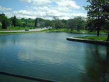
Back Cove estuary basin in Portland, Maine
External links
Deering Center
Deering Highlands
Deering Highlands is a residential neighborhood on a hill generally bordered by Woodford Street to the north; Stevens Avenue to the west; Deering Street to the east and the sloping hillside of streets in the same area, south of Brighton Avenue. The map on Barry & Anderson's _Deering: A Social and Architectural History_,[3] p. 15 is ambiguous as to the neighborhood's precise borders.
Deering Highlands was developed in the late 19th Century, and maintains much of its original historical character, including numerous examples of architecture by John Calvin Stevens, Frederic Tompson, and other regional architects. Among Highlands' most notable historical residents was conservative US Senator Ralph Owen Brewster, who owned the House at 79 Highland Street.
The neighborhood is almost entirely residential, but the largest institutional feature of the Highlands is the Maine Medical Center's Brighton Avenue Campus (formerly known as the Brighton Medical Center). The complex is now home of the New England Rehabilitation Hospital of Portland and also houses training facilities and an urgent care center.
Downtown
East Deering
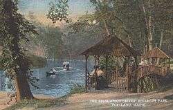
East Deering is the easternmost neighborhood of the city of Portland, Maine. The suburban neighborhood is situated between the Munjoy Hill and North Deering neighborhoods of the city, as well as the town of Falmouth. East Deering is an economically diverse place, featuring both public housing and more expensive single family homes. Much of the neighborhood has views of Casco Bay and nearby Mackworth Island East Deering was bisected by 295 in the 1960s. Major landmarks in this neighborhood include the Burnham and Morrill Co. (B&M) Baked Bean manufacturing plant, Martin's Point, Presumpscot School, Payson Park, and Lunts Corner.
Payson Park, Presumpscot Elementary School,[4] Botto's Bakery, and Martin's Point peninsula are also in the neighborhood.[5]
The major throughways in East Deering are Washington Avenue and Veranda Street. Martin's Point Bridge connects East Deering to Falmouth.
East Bayside
East Bayside is a neighborhood in Portland, Maine. It is bordered by Franklin Street on the west, Washington Avenue on the east, to the north by Marginal Way, and the south by Congress Street.[6] It was first developed a street network in the early 19th century. By the 1820s the area was Portland's second seaport via the Back Cove's ship channel. Much of the debris from the great Portland fire of 1866 was deposited into Back Cove, significantly increasing the size of East Bayside. Maps produced around 1900 show an extension of the shoreline out to Marginal Way. The shoreline would not change again until the construction of the Interstate in 1974.
East End

The East End is a neighborhood on the far eastern end of Portland's peninsula. It is closely linked with Munjoy Hill and the Eastern Promenade. The East End Community School, located on North Street, serves the area.[7] The East End Beach is also located there. Notable buildings include the Portland Observatory at the top of Munjoy Hill.
Libbytown
Libbytown[8] is a neighborhood in southern and western Portland, wedged between the Stroudwater, Rosemont, Oakdale, and Parkside neighborhoods, and separated from the city of South Portland by the Fore River.[1] Maine's busiest public transit hub, the Portland Transportation Center, is in Libbytown.
It was originally settled by Irish Catholic immigrants. Described as cohesive, it began to decline following the 1961 destruction of Union Station on St. John Street. It is named after the Libby family, who immigrated from Ireland in the mid-nineteenth century and set up three businesses between Park Avenue and outer Congress Street. It extends to the intersection of Stevens Avenue and Congress Street.[8] Tony's Donuts, a donut shop, was established in the neighborhood in 1965.[8]
Nasons Corner
The area around outer Brighton Avenue is Nasons Corner. While part of the independent town of Deering in the 1890s, the area was primarily agricultural, with acres of strawberries and fields of hay. Capisic Brook runs through part of the neighborhood, and its banks were home to the Lucas and Hamblet family-run brickyards, which were sold throughout New England. In 1898, Nasons Corner and the rest of Deering was annexed by the City of Portland. The earliest housing developments in the neighborhood were built beginning around that time and were called Brighton Avenue Terrace and Portland Garden (now Holm Street and Taft Street). The Glenwood project was underway by 1900. It included affordable bungalow style homes named for English counties (Devon, Dorset, Essex and Warwick). The Glenwood Baptist Church was built by the 1950s. The park will be part of a greening effort to restore its intended use as a "Learning Environment" by building new natural play scapes. A partnership between the City of Portland, the Nason's Corner Neighborhood Association, Breakwater School and Portland Trails. They broke ground on Tuesday, October 29, 2013 and should be completed by the fall of 2014 [9]
Sagamore Village
During World War II, many rural Mainers moved to Portland due to labor shortages in the booming defense industry based around Portland harbor. In 1943, Sagamore Village was built to ease the housing shortage. It was owned and operated by the federal government until 1953. It was a multiracial and multiethnic community, which was unique for many of the residents. Following the end of the war, the federal government sought to sell housing developments like Sagamore and Redbank in neighboring South Portland. Initially, the City Council rebuffed calls to purchase the housing development but in 1950, it reversed its position due to public pressure and purchased the housing complex. It was opened for low income individuals.[10]
North Deering
North Deering is the northernmost neighborhood of the city of Portland, Maine. It is situated next to the Riverton and East Deering neighborhoods of the city, as well as the town of Falmouth. It is home to some of the oldest surviving houses in the city, because the neighborhood was spared all of the four fires that plagued much of the rest of the city in the past. In North Deering's early history it had an agriculture and lumber based economy, but with the spread of the automobile, North Deering became more economically connected to the rest of the city. Today it has become a suburban neighborhood with some retail activity. It is home to WGME, Portland's local CBS affiliate. The Presumpscot River Preserve, a 48-acre nature preserve, is located in North Deering. It was purchased and preserved in 2001 by the Land for Maine Future program as well as the City Land Bank Commission and Portland Trails.[11]
It is served by Harrison Lyseth Elementary School, and Lyman Moore Middle School (which also serves the East Deering and Munjoy Hill neighborhoods). North Deering high school aged students choose between attending Portland High School, Deering High School, or Casco Bay High School, all three of which serve the entire city.
Oakdale
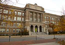
Oakdale is home to the Portland campus of the University of Southern Maine.[12] The Nathan Clifford School, built in 1907, was the neighborhood school for more than 100 years after it opened in 1907. The school was closed in 2011 and was sold to developers of market-rate housing in 2013. On January 27, 2014, the former schoolhouse was listed on the National Register of Historic Places.[13]
Old Port
Parkside
Parkside is a neighborhood located immediately around Deering Oaks, an historic park officially established in 1879. Parkside is bordered to the north by Deering Oaks. Hadlock Field, home of the Portland Seadogs, roughly forms the southern border of the neighborhood. Herb Adams, a local historian, resides in and represented the district in the Maine House of Representatives. The neighborhood began following the 1866 Great Fire of Portland, Maine when most of Portland's waterfront and downtown were burned. Residents moved south across the peninsula and laid out Sherman Ave. and Grant Ave. (now streets), named after Civil War generals William Tecumseh Sherman and future President Ulysses S. Grant. The homes in the neighborhood are primarily triple decker buildings and soon after its founding became home to much of Portland's Italian and Irish immigrant populations. The neighborhood was previously known for rampant drug use and prostitution.[14]
Peaks Island
Riverton
Riverton neighborhood is located in northwestern Portland. The Riverton Trolley Park, established in 1896, was located in the neighborhood. The park closed in 1929. At the time, it was a premier leisure destination. A trolley brought people from Monument Square to the area.[15][16][17][18] A branch of the Portland Public Library is located there as well.[19] Riverton Elementary School serves as the neighborhood school.[20] The University of New England merged with Westbrook College in 1996, with Westbrook College's campus in Riverton becoming UNE's Portland Campus. It is home of the Westbrook College Historic District.
Rosemont
Rosemont is a neighborhood in Portland located close to Deering Center and other off-peninsula neighborhoods. In 2008, it was home to a number of former city councilors.[21]
Saint John Valley
The Saint John Valley Neighborhood is located between the West End and Libbytown neighborhoods, bordered by the Parkside Neighborhood and the Fore River.
Northern Boundary: Interstate 295
Eastern Boundary: The Western Promenade, including the Maine Medical Center Campus; Congress Street, and Weymouth Street continuing along the north side of Hadlock Field to I-295.
Western Boundary: Along the Fore River from Veterans Bridge to I-295.
Southern Boundary: The intersection of Valley Street, Veterans Bridge, and Commercial Street.
The Saint John Valley Neighborhood Association was created in 2008 in an effort to define an area of the city that lacked funding and recognition. Since its inception, many improvements have been made and more are planned, such as traffic calming, beautification, and over-all streetscaping to create a more pedestrian friendly environment. The area north of I-295 and south of St. John Street is claimed by both The Saint John Valley and Libbytown Neighborhood Associations.
Stroudwater
Stroudwater is located in the southwest corner of Portland, bordered by the Nasons Corner and Libbytown neighborhoods to the north and east, the city of Westbrook to the west, and the city of South Portland to the south.[1] Maine's busiest airport, the Portland International Jetport, originally known as Stroudwater Field, is located here. Stroudwater is home to a number of historic structures, including the oldest standing publicly accessible building in Portland, the Tate House and Museum, which was built in 1755. The Stroudwater Historic District is also located here. It is home to the mouth of the Stroudwater River.
History
Stroudwater was founded as a hamlet which, with power generated by the Stroudwater River and Fore Rivers, was an important producer of masts for the Royal Navy. In the 2000s, Stroudwater was considered a quiet suburb of Downtown Portland, though it is still officially within the city boundaries.[22]
West End
The West End is a neighborhood in Portland, Maine. Located on the western side of Portland's peninsula, it includes a number of historical and well-preserved architecture.
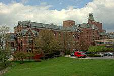
Noted for its architecture,[23] the West End is home to a number of historical homes and the Western Promenade Historic District. In 2010, it was called "one of the best preserved Victorian neighborhoods in the country".[24] The Western Promenade features prominently in the neighborhood. Other historical buildings include The Gothic House, Harrison B. Brown House, A.B. Butler House, Joseph Holt Ingraham House, Morrill Mansion, William Minott House and Waynflete School. The Western Cemetery, Portland's primary cemetery from 1829-1852, is located in the neighborhood as well. Maine Medical Center, Maine's largest hospital and Portland's largest employer, is also located in the West End. Queen Anne's Hospital was established in the West End in 1918. Renamed Mercy Hospital, it is now the fourth largest hospital in Maine.
References
- 1 2 3 "City of Portland, Maine Neighborhood Areas". Department of Public Works, City of Portland. May 2007. Retrieved 1 November 2010.
- ↑ Arts District - Portland's Cultural Center PortlandMaine.com
- ↑ Anderson, Patricia McGraw (2010). Deering A Social and Architectural History. Portland: Greater Portland Landmarks. p. 15. ISBN 978-0-939761-14-2.
- ↑ Presumpscot Elementary School PortlandSchools.org
- ↑ Busby, Chris (August 10, 2010). "Cool Summer Hot Spots!". The Bollard. Retrieved 12 October 2011.
- ↑ Public input sought on East Bayside Portland Press Herald, March 17, 2010
- ↑ East End Community School
- 1 2 3 Deans, Emma (8 July 2010). "Welcome to Nowhere - Reconnecting an amputated neighborhood". The Bollard. Retrieved 1 November 2010.
- ↑ Barry, William David; Anderson, Patricia McGraw (2010). Susan L. Ransom, ed. Deering: A Social and Architectural History. Margaret W. Soule. Portland, Maine: Greater Portland Landmarks. p. 114. ISBN 978-0-939761-14-2.
- ↑ Barry, William David; Anderson, Patricia McGraw (2010). Susan L. Ransom, ed. Deering: A Social and Architectural History. Margaret W. Soule. Portland, Maine: Greater Portland Landmarks. pp. 191–194. ISBN 978-0-939761-14-2.
- ↑ "Presumpscot River Preserve". Retrieved 22 July 2014.
- ↑ 'INSTITUTIONAL CREEP' WORRIES NEIGHBORS, CITY Portland Press Herald, September 4, 2001
- ↑ "Nathan Clifford School, Portland". Maine Historic Preservation Commission. Retrieved 15 September 2014.
- ↑ Busby, Chris (August 9, 2009). "The Dark Side of Parkside". The Bollard. Retrieved 12 October 2011.
- ↑ Welcome to the Riverton Trolley Park Portlandmaine.gov
- ↑ "Trolleys". University of Southern Maine. Retrieved 19 April 2013.
- ↑ "Riverton Trolley Park – Portland Trails". Retrieved 19 April 2013.
- ↑ "Riverton Trolley Park - Another Gem of the Portland Trails System!". WCSH 6. Retrieved 19 April 2013.
- ↑ Riverton Branch PortlandLibrary.com
- ↑ Riverton PortlandSchools.org
- ↑ Banks, Patrick (December 5, 2008). "That's My Dump!". The Bollard. Retrieved 12 October 2011.
- ↑ Insiders' Guide to Portland, Maine By Sara Donnelly, Meredith Goad
- ↑ A West End hideaway in Portland Boston Globe, September 21, 2008
- ↑ study in architecture: Portland, Maine Star Tribune, June 19, 2010