Aghdara (town)
Coordinates: 40°12′55″N 46°48′46″E / 40.21528°N 46.81278°E
| Ağdərə Martakert Մարտակերտ | ||
|---|---|---|
|
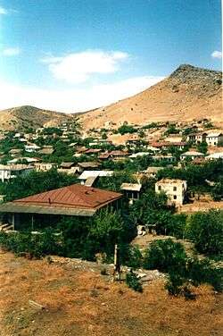
Martakert in 2002 | ||
| ||
 Ağdərə Martakert | ||
| Coordinates: 40°12′55″N 46°48′46″E / 40.21528°N 46.81278°E | ||
| Country |
De facto De jure | |
| Province Rayon |
Martakert Region Tartar District | |
| Population (2015) | ||
| • Total | 4,600 [1] | |
| Time zone | UTC (UTC+4) | |
Aghdara (Azerbaijani: Ağdərə also spelled as Agdere or Aqdara) or Martakert (Armenian: Մարտակերտ Martakert, also spelled as Mardakert) is the de facto administrative center of Martakert Region of the Nagorno-Karabakh Republic and a de jure town in the Tartar District of Azerbaijan. The town is de facto part of Nagorno-Karabakh Republic since the end of the 1991-94 Nagorno-Karabakh War.
Climate
The climate here is classified as Cfa by the Köppen-Geiger system.[2]
| Climate data for Mardakert, Nagorno-Karabakh Republic | |||||||||||||
|---|---|---|---|---|---|---|---|---|---|---|---|---|---|
| Month | Jan | Feb | Mar | Apr | May | Jun | Jul | Aug | Sep | Oct | Nov | Dec | Year |
| Average high °F (°C) | 42.4 (5.8) |
43.9 (6.6) |
51.4 (10.8) |
64.9 (18.3) |
72.3 (22.4) |
80.6 (27.0) |
87.3 (30.7) |
84.6 (29.2) |
77.5 (25.3) |
65.1 (18.4) |
54.5 (12.5) |
46.6 (8.1) |
64.26 (17.93) |
| Average low °F (°C) | 28.9 (−1.7) |
30.2 (−1.0) |
36.1 (2.3) |
46.6 (8.1) |
54.5 (12.5) |
62.1 (16.7) |
68 (20.0) |
66.2 (19.0) |
59.7 (15.4) |
49.5 (9.7) |
40.6 (4.8) |
33.1 (0.6) |
47.96 (8.87) |
| Average precipitation inches (mm) | 0.59 (15) |
0.91 (23) |
1.34 (34) |
1.77 (45) |
2.8 (71) |
2.52 (64) |
1.22 (31) |
1.02 (26) |
1.06 (27) |
1.77 (45) |
1.1 (28) |
0.67 (17) |
16.77 (426) |
| Source: http://en.climate-data.org/location/21905/ | |||||||||||||
Twin towns - sister cities
Gallery
-

Martakert church
-

Martakert house of culture
-

View from the town
-
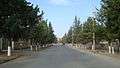
One of the main streets in Martakert
References
- World Gazetteer: Azerbaijan – World-Gazetteer.com
- Aghdara (town) at GEOnet Names Server
| Capital city | ||
|---|---|---|
| Regions | ||
| Provincial capitals | ||
| Other urban communities | ||
1 Claimed by the Nagorno-Karabakh Republic but partly under Azerbaijani control. | ||
.svg.png)
This article is issued from Wikipedia - version of the 10/26/2016. The text is available under the Creative Commons Attribution/Share Alike but additional terms may apply for the media files.