Marrowstone, Washington
| Marrowstone, Washington | |
|---|---|
| CDP | |
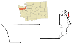 Location of Marrowstone, Washington | |
| Coordinates: 48°3′30″N 122°41′17″W / 48.05833°N 122.68806°WCoordinates: 48°3′30″N 122°41′17″W / 48.05833°N 122.68806°W | |
| Country | United States |
| State | Washington |
| County | Jefferson |
| Area | |
| • Total | 6.3 sq mi (16.4 km2) |
| • Land | 6.3 sq mi (16.4 km2) |
| • Water | 0.0 sq mi (0.0 km2) |
| Elevation | 16 ft (5 m) |
| Population (2010) | |
| • Total | 844 |
| • Density | 132.4/sq mi (51.1/km2) |
| Time zone | Pacific (PST) (UTC-8) |
| • Summer (DST) | PDT (UTC-7) |
| FIPS code | 53-43762[1] |
| GNIS feature ID | 1852949[2] |
Marrowstone is a census-designated place (CDP) in Jefferson County, Washington, United States. The population was 844 at the 2010 census. All Marrowstone addresses are in Nordland, Washington, and the ZIP code for Marrowstone Island is 98358.
Marrowstone takes its name from Marrowstone Point, the northernmost point on Marrowstone Island. It was given the name "Marrow-Stone Point" in 1792 by the British explorer, George Vancouver, in describing the area's hard, clay-like soil.[3]
Geography

Marrowstone is located at 48°3′30″N 122°41′17″W / 48.05833°N 122.68806°W (48.058323, -122.687943).[4]
According to the United States Census Bureau, the CDP has a total area of 6.3 square miles (16.4 km²), all of it land.
Prominent land features include:
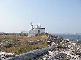
- Marrowstone Point, at the northern end of Marrowstone Island;
- Kinney Point, at the southern end of the island;
- Nodule Point, on the east side, mid island;
- Mystery Bay, an inlet on the western side of Marrowstone Island;
- Griffiths Point, on the western side of Mystery Bay;
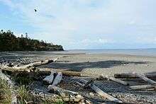
- East Beach, a sandy beach at the northern end of East Marrowstone Road; and
- Scow Bay/Kilisut Harbor, which separates Marrowstone Island from its western neighbor, Indian Island, a Navy ammunition depot.
A narrow causeway connects the southwestern end of Marrowstone Island with the southern end of Indian Island. It is necessary to cross a short bridge on the western side of Indian Island to get to the Jefferson County mainland.
Fort Flagler, a Washington state park, is situated on 784 acres (314 hectares) at the northern end of Marrowstone Island. It overlooks Port Townsend Bay and Admiralty Inlet, the entrance to Puget Sound. Fort Flagler was one of three forts, along with Fort Worden (near Port Townsend) and Fort Casey (on Whidbey Island), that guarded the entrance to Puget Sound. Mystery Bay State Park is another state park on Marrowstone Island, located on 10 acres (4 hectares) of Mystery Bay shorefront about a half-mile north of the Nordland General Store. It is primarily for boaters. Kinney Point State Park comprises 76 acres (310,000 m2) at the south end of the island. Accessible only by boat, it is part of the Cascadia Marine Trail.
Flagler Road (SR 116) runs along the western edge of Marrowstone Island, which is primarily low-lying. East Marrowstone Road runs along the eastern edge of the island, which consists largely of sandy bluffs, with the exception of the area near East Beach.
The Nordland General Store is Marrowstone's only source of groceries. It is arguably the focal point of Marrowstone; on maps the town of Nordland (the address of all Marrowstone residents) is usually located at the site of the Nordland General Store. It can be found just across Flagler Road from Mystery Bay, near the center of Marrowstone Island.
Demographics
As of the census[1] of 2010, there were 844 people, 432 households, and 260 families residing in the CDP. The population density was 133.5 people per square mile (51.5/km²). There were 611 housing units at an average density of 96.6/sq mi (37.4/km²). The racial makeup of the CDP was 96.4% White, 0.4% Native American, 0.8% Asian, 0.1% from other races, and 2.1% from two or more races. Hispanic or Latino of any race were 0.9% of the population.
There were 432 households out of which 10.4% had children under the age of 18 living with them, 55.1% were married couples living together, 3.7% had a female householder with no husband present, and 39.8% were non-families. 30.3% of all households were made up of individuals and 16.0% had someone living alone who was 65 years of age or older. The average household size was 1.95 and the average family size was 2.37.
In the CDP the population skewed older with 90.5% 18 and over, 46.3% over 62, and 36.1% who were 65 years of age or older. The median age was 60.5 years. For every 100 males there were 98.1 females.
The median income for a household in the CDP was $48,533, and the median income for a family was $54,397. Males had a median income of $45,000 versus $26,607 for females. The per capita income for the CDP was $31,146. None of the families and 0.0% of the population were living below the poverty line.
Cultural events
Polar Bear Dip
At noon on every January 1 since 1994, residents and visitors have gathered on the dock in front of the Nordland General Store for the Polar Bear Dip, organized by store owner Tom Rose. The Nordland General Store sells commemorative shirts and hats each year. Water temperatures are in the forties (Fahrenheit) and air temperatures are about the same. On more than one occasion, there has been standing ice on the water in the days prior to the Polar Bear Dip.
Strawberry Festival
For approximately 100 years, Marrowstone has held its annual Strawberry Festival in June. Residents and visitors enjoy strawberry shortcake at the Nordland Garden Club Building. Strawberries were once grown all over Marrowstone and can be found growing wild on the island.
Tractor Days Parade
Every Memorial Day weekend, island residents bring their tractors to parade them in front of the Nordland General Store.
Marrowstone Island Community Association
The Marrowstone Island Community Association hosts the Strawberry Festival each year. It meets about 7 times throughout the year at the Nordland Garden Club Building.
Early Home of Marrowstone Music Festival
The Seattle Youth Symphony's Marrowstone Music Festival - now called Marrowstone Summer Music and held on the campus of Western Washington University, in Bellingham, Washington – was held at Fort Flagler on the northern end of Marrowstone Island from 1958 until 1989. Until 1975, it was called the Pacific Northwest Music Camp.
Home to modern Eleusianian Mysteries
The neo-pagan Aquarian Tabernacle Church performs a modern Eleusinian Mysteries play at Fort Flagler over Easter weekend each year.
References
- 1 2 "American FactFinder". United States Census Bureau. Retrieved 2008-01-31.
- ↑ "Marrowstone". Geographic Names Information System. United States Geological Survey.
- ↑ Roberts, John E. (2005). A Discovery Journal: George Vancouver's First Survey Season - 1792. Trafford Publishing. p. 36. ISBN 978-1-4120-7097-3.
- ↑ "US Gazetteer files: 2010, 2000, and 1990". United States Census Bureau. 2011-02-12. Retrieved 2011-04-23.
External links
| Wikimedia Commons has media related to Marrowstone Island. |
Municipalities and communities of Jefferson County, Washington, United States | ||
|---|---|---|
| City | 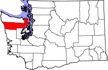 | |
| CDPs | ||
| Other unincorporated communities | ||
| Indian reservation | ||
| Ghost town | ||
| Footnotes | ‡This populated place also has portions in an adjacent county or counties | |