Marine archeology in the Gulf of Khambhat
Marine archeology in the Gulf of Khambhat - earlier known as Gulf of Cambay - centers on findings made in December 2000 by the National Institute of Ocean Technology (NIOT). NIOT came across palaeo river channels in the sea. These were seen by the scientists involved to be the extension of the present day major rivers of the area. In a similar marine survey, in a Coastal Research Ship during 1999-2000 when Dr S Badrinaryan was the Chief Scientist, several unusual frames of Side Scan Sonar images were encountered. These had square and rectangular features in an arranged geometric fashion which are not expected by the scientist in the marine domain. As per the scientist involved such features are unlikely to be due to natural marine geological processes. This made the scientists suspect that human workmanship must have been involved here. The surveys were followed up in the following years and two palaeo channels of old rivers were discovered in the middle of the Khambhat area under 20-40m water depths, at a distance of about 20 km from the present day coast.[1]
Initial discovery
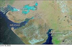
On 19 May 2001, India's Union Minister for Human Resource Development, Science and Technology division, Murli Manohar Joshi, announced that the ruins of an ancient civilization had been discovered off the coast of Gujarat, in the Gulf of Khambhat. The site was discovered by NIOT while they performed routine pollution studies using sonar, and was described as an area of regularly spaced geometric structures. It is located 20 km from the Gujarat coast, spans 9 km, and can be found at a depth of 30–40 meters. In his announcement, Joshi represented the site as an urban settlement that pre-dates the Indus Valley Civilization.[2] Further descriptions of the site by Joshi describe it as containing regularly spaced dwellings, a granary, a bath, a citadel, and a drainage system.[3] However it was later on 22 May, reported that the discovery has not been dated and the discovery (for example, great baths) resembles the Harappan civilization dating 4,000 years ago. Furthermore, the Indus civilization port Lothal is located at the head, Gulf of Khambhat.[4]
Follow-up excavations
A follow-up investigation was conducted by NIOT in November 2001, which included dredging to recover artifacts and sonar scans to detect structures. Among the artifacts recovered were a piece of wood, pottery sherds, weathered stones initially described as hand tools, fossilized bones, and a tooth. Artifacts were sent to the National Geophysical Research Institute (NGRI) in Hyderabad, India, the Birbal Sahni Institute of Paleobotany (BSIP) in Lucknow, India, and the Physical Research Laboratory in Ahmedabad, India.[5] The piece of wood was carbon dated to an age of 9,500 years old.[2]
NIOT returned for further investigation in the Gulf from October 2002 to January 2003. During these excavations, NIOT reported finding two paleochannels flanked by rectangular and square basement-like features. Artifacts were recovered by means of dredging, including pottery sherds, microliths, wattle and daub remains, and hearth materials. These artifacts were sent for dating at the laboratories of Manipur University and Oxford University. The wattle and daub remains are composed of locally available clay, reed, husk, pottery pieces, and pieces of fresh water shell. The wattle and daub also shows evidence of partial burning.[5]
The most recent work in the Gulf of Khambhat took place from October 2003 to January 2004 and was primarily a geologic study. Techniques used during this investigation include bathymetry survey, sub-bottom survey, side-scan survey, and magnetic survey. One of the major findings from this investigation concerns the orientation of sand ripples at the site. NIOT researchers claim that there are two sets of ripples visible at the site; One set is a natural feature formed by tidal currents, whilst they say the other set has formed in relation to underlying structural features.[5]
Controversies
Carbon dates
One of the main controversies surrounding the GKCC is the dated piece of wood. Dr. D.P. Agrawal, chairman of the Paleoclimate Group and founder of Carbon-14 testing facilities in India stated in an article in Frontline Magazine that the piece was dated twice, at separate laboratories.[2] The NGRI in Hyderabad returned a date of 7190 BC and the BSIP in Hannover returned a date of 7545-7490 BC.[5] Some archeologists, Agrawal in particular, contest that the discovery of an ancient piece of wood does not imply the discovery of an ancient civilization. Agrawal argues that the wood piece is a common find, given that 20,000 years ago the Arabian Sea was 100 meters lower than its current level, and that the gradual sea level rise submerged entire forests.[2][6]
Artifacts
Another controversial issue are the artifacts retrieved from the site during the various excavations. It is disputed that many of the items that have been identified as artifacts by the NIOT investigators are actually man-made. Instead their artificial nature is contested and they are argued to be stones of natural origin.[6]
Researchers report finding shards of pottery as indicative of hand-made and wheel-turned pottery traditions. The reported shards have simple rims with small incised lines. All of the pottery fragments found so far are small or miniature shards.[5] Part of the controversy is that some of the "shards" are natural geofacts and others lack any proof of any connections, as with the dated pieces of wood, with the purported "ruins" found by NIOT researchers. In addition, their small size also raises the possibility that the real shards have been transported from elsewhere by local, strong tidal currents. But if the pottery is genuine, researchers say it should show some similarities to Harappan pottery, which is typically red and black and stamped with seals. Based on the current pottery collection, a stylistic continuity of Harappan civilization isn't evident. The small size of the artifact collection makes it difficult to analyse the pottery conclusively.[2][6]
Geography
The Gulf of Khambhat was formed by a major rift that resulted in a down sliding of the Khambhat region. The area is very tectonically active today, and several faults can be found in the gulf. Periodic earthquakes also occur here.[5] This knowledge has led several archeologists to state that the site is not in a secure enough context to be reliably dated. Because of the tectonic activity and strong currents, these archeologists claim that there is not sufficient stratification to be sure the recovered artifacts can be associated with the site.[2][6]
Collection methods
Complaints have arisen because NIOT recovered artefacts by dredging the sea floor of the site. This method might allow errant artefacts to be collected along with those that actually correlate with the site. Analysing stratification is virtually impossible with this method as well.[2][6]
See also
- Dwaraka Kingdom
- Archaeological Survey of India
- Mahabharata
- Indology
- Historiography and nationalism
- Pseudoarchaeology
References
- ↑ Gulf of Cambay Cradle of Ancient Civilization .
- 1 2 3 4 5 6 7 Bavadam, Lyla. "Questionable claims: Archaeologists debunk the claim that underwater structures in the Gulf of Khambat point to the existence of a pre-Harappan civilisation." Frontline 2–15 March 2002.
- ↑ Mudur, G.S. "Forgotten Metropolis on Seabed." The Telegraph [Calcutta, India] 19 May 2001. .
- ↑ Rao, R. "Indian seabed hides ancient remains." BBC News [Delhi, India] 22 May 2001. .
- 1 2 3 4 5 6 Kathiroli, S. "Recent Marine Archaeological Finds in Khambhat, Gujarat." Journal of Indian Ocean Archaeology 2004: 141-149. Online.
- 1 2 3 4 5 Witzel, Michael, 2006, Rama’s realm: Indocentric rewritings of early South Asian archaeology and history in Fagan, G. G., ed., Archaeological Fantasies. Routledge Taylor, and Francis Group, New York ISBN 0-415-30593-4
External links
- National Institute of Ocean Technology (India)
- National Institute of Oceanography (India)
- Badrinaryan, B. (2006) Gulf of Cambay Cradle of Ancient Civilization., Articles, Graham Hancock web site.
- Handwerk, B. (2002) New Underwater Finds Raise Questions About Flood Myths., National Geographic (May 28, 2002)
- Heinrich, P. V. (2002) Artifacts or Geofacts? Alternative Interpretations of Items from the Gulf of Cambay., The Hall of Ma'at (May 2002)
- News links
- The Gulf of Khambat debate. Frontline, 12 April 2002
- Indian seabed hides ancient remains. BBC, 22 May 2001.
- Lost city 'could rewrite history'. BBC, 19 January 2002.