Marcinkonys
| Marcinkonys | ||
|---|---|---|
| Village | ||
|
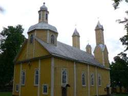
Wooden church of Marcinkonys (built 1880) | ||
| ||
 Marcinkonys Location of Marcinkonys | ||
| Coordinates: 54°03′40″N 24°24′0″E / 54.06111°N 24.40000°ECoordinates: 54°03′40″N 24°24′0″E / 54.06111°N 24.40000°E | ||
| Country |
| |
| Ethnographic region | Dzūkija | |
| County |
| |
| Municipality | Varėna district municipality | |
| Eldership | Marcinkonys eldership | |
| Capital of | Marcinkonys eldership | |
| Population (2001) | ||
| • Total | 765 | |
| Time zone | EET (UTC+2) | |
| • Summer (DST) | EEST (UTC+3) | |

Marcinkonys is a village in Varėna district, Lithuania, located south-east of Merkinė. It is the administrative center of the Dzūkija National Park and Čepkeliai Marsh. According to the 2001 census, it had 765 residents.[1]
Its alternate names include Marcinkańce, Mareinkonys, Martsinkantse, Martsinkantsy, and Martsinkonis.[2]
The settlement is known since 1637, when it was a camp of foresters. It began growing after completion of the railway station for the Warsaw – Saint Petersburg Railway in 1864. During the Holocaust, the village had the Marcinkonys Ghetto for the Lithuanian Jews. Some Jews escaped during the liquidation of the ghetto and managed to survive the war.[3]
References
- ↑ Alytaus apskrities kaimo gyvenamosios vietovės ir jų gyventojai (PDF) (in Lithuanian). Vilnius: Department of Statistics to the Government of the Republic of Lithuania. 2002. p. 55. ISBN 9986-589-83-5.
- ↑ United States Board of Geographic Names - Marcinkonys. Accessed January 23, 2014.
- ↑ Browning, Christopher R. (2000). Nazi policy, Jewish workers, German killers. Cambridge University Press. pp. 157–160, 166. ISBN 978-0-521-77490-1.
This article is issued from Wikipedia - version of the 10/30/2016. The text is available under the Creative Commons Attribution/Share Alike but additional terms may apply for the media files.