Marakei
 Map of Marakei | |
 | |
| Geography | |
|---|---|
| Location | Pacific Ocean |
| Coordinates | 2°00′N 173°17′E / 2.000°N 173.283°E |
| Archipelago | Gilbert Islands |
| Area | 14.13 km2 (5.46 sq mi) |
| Highest elevation | 3 m (10 ft) |
| Administration | |
| Demographics | |
| Population | 2,872 (2010 Census) |
| Pop. density | 203 /km2 (526 /sq mi) |
| Ethnic groups | I-Kiribati 98.9% |
Marakei is a small atoll in the North Gilbert Islands. The central lagoon consists of numerous deep basins and surrounded by two large islands which are separated by two narrow channels. The atoll covers an area of approximately 40 km².
Geography
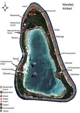
The total land area of Marakei is 14.13 square kilometers. A road circles the island and is 26 kilometers long while the length of the island from the airport and running through the lagoon to Teraereke at southern portion of the island is 9.93 kilometers. It widest width can be found in the village of Rawannawi and narrowest width at Temotu at the western side of the island. Marakei is one of only two islands in Kiribati that encircles its lagoon. The Marakei lagoon is saltwater and deep in some areas, but not tidal. Two narrow channels, which are not navigable at low tide, link the lagoon with the sea; these are called Baretoa Pass and Raweta Pass.[1]
Rawata Pass was the location of an obstruction in 1912 after inter-village conflict.
Environmental issues
The construction of causeways have also resulted to significant reduction in the flushing of the lagoon that has resulted in low levels of oxygen in the lagoon, which has resulted in the water becoming stagnant so that fish no longer found in the lagoon.[2] The erosion and accretion that are occurring along the shoreline is identified as being linked to aggregate mining, land reclamation and the construction of causeways that has been thought to change the currents along the shoreline.[2]
Villages
The main village is Rawannawi, which at the time of the 2010 Census[3] was home to just over a third of the island's 2,872 people.
| Rawannawi | 1000 inhabitants |
| Temotu | 164 inhabitants |
| Buota | 339 inhabitants |
| Tekarakan | 358 inhabitants |
| Bwainuna | 310 inhabitants |
| Norauea | 321 inhabitants |
| Tekuanga | 217 inhabitants |
| Antai | 163 inhabitants |
Myths and legends
There are different stories told as to the creation of Marakei and the other islands in the Southern Gilberts. An important legend in the culture of Marakei is that spirits who lived in a tree in Samoa migrated northward carrying branches from the tree, Te Kaintikuaba, which translates as the tree of life.[2] It was these spirits, together with Nareau the Wise who created the islands of Tungaru (the Gilbert Islands).[Note 1]
History
Marakei Post Office opened around 1912.[6]
Visiting Marakei

The "katabwanin" is a tradition unique to Marakei; first time visitors need to pay their respects to the four ghosts of Marakei, travelling anticlockwise, before any other activities. Offerings of tobacco, sweets or money at the shrines of Nei Reei, Nei Rotebenua, Nei Tangangau and Nei Nantekimam will secure a happy stay in Marakei.
Airport
Marakei is served by Marakei Airport at the northern tip of the island (close to the village of Rawannawi). Air Kiribati runs three flights each week to Abaiang and the international airport at Tarawa.
Accommodation
The Council guesthouse on Marakei is situated right on the ocean, just outside the main village of Rawannawi.[7] Like all Island Council guesthouses in Kiribati, facilities are basic and food is what is available locally, however its spectacular location and the Marakei tradition of hospitality mean that a stay in the Marakei guesthouse can be a once in a lifetime experience for the well prepared traveler.
Notes
- ↑ Sir Arthur Grimble, cadet administrative officer in the Gilberts from 1914 and resident commissioner of the Gilbert and Ellice Islands colony from 1926, recorded the myths and oral traditions of the Kiribati people. He wrote the best-sellers A Pattern of Islands (London, John Murray 1952,[4] and Return to the Islands (1957), which was republished by Eland, London in 2011, ISBN 978-1-906011-45-1. He also wrote Tungaru Traditions: writings on the atoll culture of the Gilbert Islands, University of Hawaii Press, Honolulu, 1989, ISBN 0-8248-1217-4.[5]
References
- ↑ "3. Marakei" (PDF). Office of Te Beretitent - Republic of Kiribati Island Report Series. 2012. Retrieved 28 April 2015.
- 1 2 3 Dr Temakei Tebano & others (October 2008). "Island/atoll climate change profiles - Marakei Atoll". Office of Te Beretitent - Republic of Kiribati Island Report Series (for KAP II (Phase 2). Archived from the original on November 6, 2011. Retrieved 28 April 2015.
- ↑ "Kiribati Census Report 2010 Volume 1" (PDF). National Statistics Office, Ministry of Finance and Economic Development, Government of Kiribati. Retrieved 17 March 2013.
- ↑ Grimble, Arthur (1981). A Pattern of Islands. Penguin Travel Library. Penguin Books. ISBN 0-14-009517-9.
- ↑ Grimble, Arthur (1989). Tungaru traditions: writings on the atoll culture of the Gilbert Islands. Penguin Travel Library. University of Hawaii Press. ISBN 978-0-8248-1217-1.
- ↑ Premier Postal History. "Post Office List". Premier Postal Auctions. Retrieved 5 July 2013.
- ↑ "Kiribati Tourism Outer Islands Accommodation Guide". Government of Kiribati. July 2012. Retrieved 9 March 2013.
| Gilbert Islands |  | |
|---|---|---|
| Phoenix Islands | ||
| Line Islands | ||
| West of Gilberts | ||
| Reefs | ||
| ||
Coordinates: 2°00′N 173°16′E / 2.000°N 173.267°E