Maplesville, Alabama
| Maplesville, Alabama | |
|---|---|
| Town | |
 | |
 Location in Chilton County and the state of Alabama | |
| Coordinates: 32°46′55″N 86°52′32″W / 32.78194°N 86.87556°W | |
| Country | United States |
| State | Alabama |
| County | Chilton |
| Area | |
| • Total | 3.3 sq mi (8.6 km2) |
| • Land | 3.3 sq mi (8.5 km2) |
| • Water | 0.04 sq mi (0.1 km2) |
| Elevation | 351 ft (107 m) |
| Population (2010) | |
| • Total | 708 |
| • Density | 217/sq mi (83.6/km2) |
| Time zone | Central (CST) (UTC-6) |
| • Summer (DST) | CDT (UTC-5) |
| ZIP code | 36750 |
| Area code(s) | 334 |
| FIPS code | 01-46504 |
| GNIS feature ID | 0160032 |
| Website |
www |
Maplesville is a town in Chilton County, Alabama, United States. At the 2010 census the population was 708.[1]
The mayor of Maplesville is W. C. Hayes, Jr.
History
The town of Maplesville first began to grow in a location 3 miles (5 km) east of its present location, near Mulberry Creek. European settlers migrated to the area from Georgia and the Carolinas following the Battle of Horseshoe Bend in 1814, after the Native Americans who had been living there were defeated. The town was named after Stephen W. Maples, a merchant and the town's first postmaster.
The town was located at the crossroads of two important trading routes: the Elyton Road from Selma to Birmingham, and the Fort Jackson Road from Tuscaloosa to Montgomery. By 1850, the original town of Maplesville had a population of 809. The town had two horse-racing tracks, which brought visitors to the town, and had several inns and taverns to accommodate the stagecoach traffic.
The original town site began to decline in the early 1850s, after two railway lines were completed 3 miles west of the town. The Selma, Rome, and Dalton Railroad completed their line in 1850, and the Alabama & Tennessee River Railway followed in 1853. That same year, a depot was constructed at that location. Residents and businesspeople from the original Maplesville began moving closer to the railroad, and when the Maplesville Post Office was relocated to the railroad town in 1856, the new town was renamed Maplesville. The original town site gradually became deserted, and all that remains today is the Old Maplesville Cemetery along Route 191.
Because of Maplesville's abundant rail access, it became a shipping point for cotton and other goods from the surrounding area. In 1865, the train depot was destroyed in a raid by Union general James H. Wilson, as Wilson's Raiders marched on to Selma. It was replaced soon after the Civil War, but was destroyed by fire in 1911.
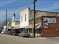
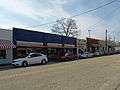
Maplesville continued to prosper after the Mobile and Ohio Railroad ran a line through the town in 1897, and many of the historic buildings in the town today were built during that period. In 1901, a lumber mill opened near the town, and the town's population grew as people moved to Maplesville to work at the mill. Maplesville incorporated in 1914, but the incorporation soon lapsed because the town failed to hold elections after the initial round. It reincorporated in 1947, and by 1951 had established a telephone system, garbage pick-up, and water system.
A new town hall was completed in 1975.[2][3]
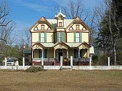
There are four historic sites currently recognized in Maplesville. The Walker-Klinner Farm is listed on the National Register of Historic Places, and the following three locations are listed on the Alabama Register of Landmarks and Heritage:
- Maplesville Depot (circa 1912; listed November 23, 1976).
- Maplesville Methodist Episcopal Church (circa 1870–1890; listed December 4, 1992).
- Maplesville Railroad Historic District (19th–20th century; listed September 26, 2003).
Geography
Maplesville is located in southwestern Chilton County at 32°46'54.800" North, 86°52'31.861" West (32.781889, -86.875517).[4]
According to the U.S. Census Bureau, the town has a total area of 3.3 square miles (8.6 km2), of which 3.3 square miles (8.5 km2) is land and 0.04 square miles (0.1 km2), or 1.22%, is water.[1]
Demographics
| Historical population | |||
|---|---|---|---|
| Census | Pop. | %± | |
| 1920 | 376 | — | |
| 1930 | 456 | 21.3% | |
| 1950 | 806 | — | |
| 1960 | 679 | −15.8% | |
| 1970 | 596 | −12.2% | |
| 1980 | 754 | 26.5% | |
| 1990 | 725 | −3.8% | |
| 2000 | 672 | −7.3% | |
| 2010 | 708 | 5.4% | |
| Est. 2015 | 704 | [5] | −0.6% |
| U.S. Decennial Census[6] 2013 Estimate[7] | |||
As of the census[8] of 2007, there were 2500 people, 268 households, and 183 families residing in the town. The population density was 205.8 people per square mile (79.6/km²). There were 313 housing units at an average density of 95.9 per square mile (37.1/km²). The racial makeup of the town was 69.94% White, 29.61% Black or African American and 0.45% Native American. 0.89% of the population were Hispanic or Latino of any race.
There were 268 households out of which 32.8% had children under the age of 18 living with them, 52.2% were married couples living together, 11.9% had a female householder with no husband present, and 31.7% were non-families. 30.2% of all households were made up of individuals and 12.7% had someone living alone who was 65 years of age or older. The average household size was 2.51 and the average family size was 3.13.
In the town the population was spread out with 25.3% under the age of 18, 10.1% from 18 to 24, 26.9% from 25 to 44, 23.5% from 45 to 64, and 14.1% who were 65 years of age or older. The median age was 37 years. For every 100 females there were 95.9 males. For every 100 females age 18 and over, there were 88.0 males.
The median income for a household in the town was $27,500, and the median income for a family was $36,250. Males had a median income of $31,042 versus $22,361 for females. The per capita income for the town was $12,777. About 12.6% of families and 20.1% of the population were below the poverty line, including 26.7% of those under age 18 and 16.0% of those age 65 or over.
Things to see and do in Maplesville
Attractions
- Noah's Motorcross Park
- Perry Mountain Motorcycle Club
- L & M Auctions & Appraisals
- Minooka Park
- Snake Pit Racing
- Norman Smith Pottery
- Numerous scenic walking trails
Places of worship
- Maplesville Baptist Church
- Maplesville United Methodist Church
- Pilgrim Rest Baptist Church
- Happy Church, Inc./Christian Life Church Learning Center
Historic cemeteries
- Goodwin Family Cemetery
- Atchison Family Cemetery
Historic buildings
- Walker-Klinner Farm
- Maplesville Depot
- Maplesville Methodist Church
- Maplesville Railroad Historic District
- Ebenezer Baptist Church
Notable people
- Tommie Agee, former Auburn and NFL player
- Harold Morrow, former Auburn and NFL fullback
Gallery


References
- 1 2 "Geographic Identifiers: 2010 Demographic Profile Data (G001): Maplesville city, Alabama". U.S. Census Bureau, American Factfinder. Retrieved June 4, 2014.
- ↑ "History of Maplesville, Alabama". Town of Maplesville, Alabama. Retrieved March 2013. Check date values in:
|access-date=(help) - ↑ Kaetz, James P. (February 7, 2013). "Maplesville". Encyclopedia of Alabama.
- ↑ "US Gazetteer files: 2010, 2000, and 1990". United States Census Bureau. 2011-02-12. Retrieved 2011-04-23.
- ↑ "Annual Estimates of the Resident Population for Incorporated Places: April 1, 2010 to July 1, 2015". Retrieved July 2, 2016.
- ↑ "U.S. Decennial Census". Census.gov. Retrieved June 6, 2013.
- ↑ "Annual Estimates of the Resident Population: April 1, 2010 to July 1, 2013". Retrieved June 3, 2014.
- ↑ "American FactFinder". United States Census Bureau. Retrieved 2008-01-31.
External links
Coordinates: 32°46′55″N 86°52′32″W / 32.781889°N 86.875517°W
Municipalities and communities of Chilton County, Alabama, United States | ||
|---|---|---|
| Cities |  | |
| Towns | ||
| Unincorporated communities | ||
| Footnotes | ‡This populated place also has portions in an adjacent county or counties | |