Manno Lake
| Manno Lake 満濃池 | |
|---|---|
|
Manno Lake | |
| Location | Manno, Kagawa |
| Coordinates | 34°09′43″N 133°52′26″E / 34.162°N 133.874°ECoordinates: 34°09′43″N 133°52′26″E / 34.162°N 133.874°E |
| Primary inflows | Doki River, Kanakura River |
| Basin countries | Japan |
| Surface area | 1.385 km2 (0.535 sq mi) |
| Max. depth | 30.14 m (98.9 ft) |
| Water volume | 0.0154 km3 (12,500 acre·ft) |

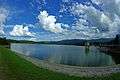
Manno Lake (Mannō Ike) in Mannō, Kagawa, Japan, is a man-made irrigation reservoir with a reserve capacity of 1,540 tons. It is vaguely shaped like a human hand.
History
701-704 (Taiho era ): Michimori Ason, the lord of Sanuki Province, erects the first dam.
818 (Kōnin era, year 9): Mannō Pond dam ruptures due to flooding.
821 (Kōnin era, year 12): Kukai is dispatched to oversee renovations of Mannō Pond dam, with construction being completed in approximately 3 months. Between the years of 821 and 1184, the Manno Pond dam collapses and is subsequently restored many times.
1184 (Genryaku era, year 1): After the collapse of the dam in 1184, all rebuilding efforts were abandoned until 1628 (Kan’ei, year 5). During this period, people settled in the basin constructing houses and cultivating fields. The settlement was named Ikeato Mura (After-Pond village).
1628 (Kan’ei era, year 5): By order of Takamatsu Domain feudal lord Ikoma Takatoshi the fushin-bugyō Nichijima Hachibe’e begins renovations of the Mannō Pond dam.
1631 (Kan’ei era, year 8): The Takamatsu domain completes renovations of the dam.
1854 (Ansei era, year 1): Dam collapses due to earthquake.
1870 (Meiji era, year 3): Restoration of dam completed. Afterward restorations, the three separate constructions of the Tenkawa headrace began, in order to supplement water intake from the Dokigawa, resulting in an increase of water volume three times.
1996 (Heisei era, year 8): Manno Pond selected as one of the One Hundred Soundscapes of Japanby the Ministry of the Environment.
2000 (Heisei era, year 12): Mannō Pond Conduit Gates (Japanese: 満濃池樋門, Hepburn: Mannō-Ike Himon) registered as Japanese cultural landmark- (buildings).
2005: The Manno Pond dam receives the Dammed Lake Hyakusen certification from the Dam Watershed Environmental Improvement Center.
2010: Manno Pond recieces the Pond Hyakusen certification from the Japanese Ministry of Agriculture, Forestry, and Fisheries.
Data

Current Data
Dam type: Earth-filled storage dam
Dam height: 32.0m
Dam length: 155.8m
Shore Length: 19.7km
Water volume: 15,400,000 cubic meters
Waterbody surface area: 342.2 acres
Basin Surface area: 348.9 acres
Catchment area: 8004 acres
Tributaries: Kanakura River, Doki River (via the Tenkawa Headrace)
Data from 821 (Konin era, year 12)
Dam height: 22m
Shore length: 10.58km
Waterbody surface area: 200acres
Water volume: 5,000,000 cubic meters
Tributaries: Kanakura river
Data from 1631 (Kan’ei era, year 8)
Dam height: 22.72m
Dam length: 81.81m
Shore length: 8.2km
Regions supplied with water: 128.704 square kilometers between Naka-Gun, Uta-Gun, and Tado-Gun
Tributaries: Kanakura river
Data from various embankment constructions
First embankment construction water volume: 6,678,000 cubic meters
Second embankment construction water volume: 7,800,000 cubic meters
Third embankment construction water volume: 15,400,000 cubic meters
Yuru-Nuki

A "Yuru" is a water reservoir plug.
The Yuru-Nuki ceremony, which is held on annually on June 15 at Manno Pond, releases water to irrigate fields for the rice-planting season.
Gallery


Access

- Car:
<From Okayama, Ehime, and Kochi>
About 30 minutes from Zentsuji IC of Takamatsu Expressway
<From Tokushima>
About 55 minutes from Mima IC of Tokushima Expressway
- Railway:
<JR>
About 15 minutes by taxi from Kotohira station
<Kotoden>
About 20 minutes by taxi from Kotoden Kotohira Station/
About 15 minutes by taxi from Okada Station
- Airplane:
<Takamatsu Airport> About 55 minutes by taxi
External links
 Media related to Mannō, Kagawa at Wikimedia Commons
- Official website (Japanese)