Manning, North Dakota
| Manning, North Dakota | |
|---|---|
| Census-designated place | |
|
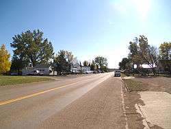
Street in Manning | |
 Manning Location within the state of North Dakota | |
| Coordinates: 47°13′45″N 102°46′09″W / 47.22917°N 102.76917°WCoordinates: 47°13′45″N 102°46′09″W / 47.22917°N 102.76917°W | |
| Country | United States |
| State | North Dakota |
| County | Dunn |
| Area[1] | |
| • Total | 0.575 sq mi (1.49 km2) |
| • Water | 0 sq mi (0 km2) |
| Elevation | 1,834 ft (559 m) |
| Population (2010)[2] | |
| • Total | 74 |
| • Density | 130/sq mi (50/km2) |
| Time zone | Mountain (MST) (UTC-7) |
| • Summer (DST) | MDT (UTC-6) |
| ZIP Code | 58642 |
| Area code(s) | 701 |
| FIPS code | 38-50220[3] |
| GNIS feature ID | 2628576[3] |
Manning is a census designated place (CDP) in and the county seat of Dunn County, North Dakota, United States.[4] An unincorporated community, it was designated as part of the U.S. Census Bureau's Participant Statistical Areas Program on March 31, 2010.[5] It was not counted separately during the 2000 Census,[6] but was included in the 2010 Census,[7] where a population of 74 was reported.[2] Its ZIP Code is 58642.
| Historical population | |||
|---|---|---|---|
| Census | Pop. | %± | |
| 2010 | 74 | — | |
| U.S. Decennial Census | |||
Climate
This climatic region is typified by large seasonal temperature differences, with warm to hot (and often humid) summers and cold (sometimes severely cold) winters. According to the Köppen Climate Classification system, Manning has a humid continental climate, abbreviated "Dfb" on climate maps.[8]
References
- ↑ "US Gazetteer files: 2010, 2000, and 1990". United States Census Bureau. 2011-02-12. Retrieved 2011-04-23.
- 1 2 "2010 Census Redistricting Data (Public Law 94-171) Summary File". American FactFinder. United States Census Bureau. Retrieved May 2, 2011.
- 1 2 "US Board on Geographic Names". United States Geological Survey. 2007-10-25. Retrieved 2008-01-31.
- ↑ "Find a County". National Association of Counties. Retrieved 2011-06-07.
- ↑ "Manning Census Designated Place". Geographic Names Information System. United States Geological Survey. Retrieved 2010-07-13.
- ↑ U.S. Census Bureau (2003). "Population and Housing Unit Counts, North Dakota" (PDF). 2000 Census of Population and Housing. Government Printing Office. Retrieved 2008-07-20.
- ↑ U.S. Census Bureau (February 13, 2008). "Census Designated Place (CDP) Program for the 2010 Census—Final Criteria" (PDF). Federal Register. Retrieved 2010-07-13.
- ↑ Climate Summary for Manning, North Dakota
Municipalities and communities of Dunn County, North Dakota, United States | ||
|---|---|---|
| Cities | 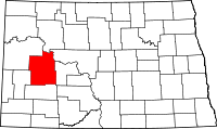 | |
| CDP | ||
| Unorganized territories |
| |
| Unincorporated communities |
| |