Manggahan Floodway
| Manggahan Floodway | |
 | |
| Country | Philippines |
|---|---|
| Region | Metro Manila, Rizal |
| Source | Marikina River |
| - location | Pasig City, Metro Manila |
| - coordinates | PH 14°35′56″N 121°05′25″E / 14.59889°N 121.09028°E |
| Mouth | Laguna de Bay |
| - location | Taytay, Rizal |
| - coordinates | PH 14°31′30″N 121°08′10″E / 14.52500°N 121.13611°ECoordinates: PH 14°31′30″N 121°08′10″E / 14.52500°N 121.13611°E |
| Length | 10 km (6 mi) |
 Pasig-Marikina River basin with the Manggahan Floodway shown in cyan. | |
The Manggahan Floodway is an artificially constructed waterway in Metro Manila, the Philippines. The floodway was built in 1986,[1] with the cost of 1.1 billion pesos, in order to reduce the flooding along the Pasig River during the rainy season, by diverting the peak water flows of the Marikina River to the Laguna de Bay which serves as a temporary reservoir.[2][3] In case the water level on the lake is higher than the Marikina River, the floodway can also reverse the flow.
By design, the Manggahan Floodway is capable of handling 2,400 cubic meters per second of water flow, although the actual flow is about 2,000 cubic meters per second. To complement the floodway, the Napindan Hydraulic Control System (NHCS) was built in 1983 at the confluence of the Marikina River and the Napindan Channel of the Pasig River to regulate the tidal flow of saline water between Manila Bay and the lake, and to prevent the intrusion of polluted water into the lake.[2]
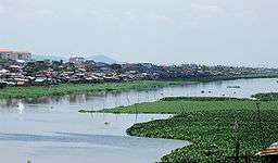
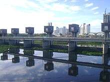
It has a fully gated diversion dam at its head and was designed with a width of 260 meters (850 ft). Over 40,000 households are situated along the floodway's banks [4] and these shoreline slums have reduced its effective width to 220 meters (720 ft). Kangkong is cultivated extensively in the floodway as well.
Bridges
The floodway has only 4 bridges. The 3 bridges within Pasig City are Manggahan Bridge (near Marikina River), Ortigas Bridge (carries Ortigas Avenue Extension) and F.B. Legaspi Bridge. Barkadahan Bridge is the last and only nearest bridge to the lakeshore of Laguna de Bay located at Taytay, Rizal.
Environmental concerns
By carrying flood waters to Laguna de Bay, the Manggahan Floodway lessens flood conditions in Metro Manila but contributes to flooding of the coastal areas of Taguig, Taytay, and other towns in Laguna and Rizal along the lake. Incidents of severe floods became more frequent and lasted longer in these areas since its construction.[1] An unusual large flood occurred in October/November 1986, lasting for 2 months and resulting in high mortality and morbidity rates due to gastroenteritis and other water-borne diseases.[5]
Furthermore, pollution and sediments carried by the floodway will jeopardize the existing and potential uses of the lake. The sedimentation rate of the lake is estimated at 1.5 million m³/year with the Marikina River as a major contributor of silt to the lake through the Manggahan Floodway.[2] Additional pollution comes from the shoreline settlers, living in slums up to 5 rows deep, whose waste goes directly into the floodway.[6]
2009 flood

On September 26, 2009, at about 6:00 pm PST, the 50-mph "Tropical Storm Ketsana" (called "Ondoy" in the Philippines) hit Metro Manila and dumped one month's rainfall in less than 24 hours, causing the Marikina River system, including the Manggahan Floodway, to burst its banks very rapidly. It is thought that blocked pipes and a poorly maintained sewer system, along with uncollected domestic waste, were major contributory factors in the speed with which the flood waters were able to engulf the surrounding area. The illegal settlers especially were blamed for flooding since their houses reduce the effective width and blocked the flow of the floodway. During the height of the storm, the Marikina River had a flow of about 3000 m³/s (106,000 ft³/s), and the head of the UP National Hydraulic Research Center stated that the floodway could have handled this flow without overflowing if there were no settlers on its banks.[7]
Consequently, in February 2010, President Gloria Macapagal-Arroyo revoked Proclamation 160 that reserved 20 parcels of land along the floodway for 6700 urban poor families, and ordered the forcible relocation of the illegal settlers whose houses were blocking the waterway to Laguna de Bay.[8]
References
- 1 2 "Background on the Mega-Dike Issue". Leaders and Organizers of Community Organization in Asia. Archived from the original on 2002-08-05. Retrieved 2009-07-21.
- 1 2 3 "Laguna de Bay Masterplan". Laguna Lake Development Authority. Archived from the original on January 29, 2009. Retrieved 2009-07-21.
- ↑ Alcazaren, Paulo (June 15, 2013). "City Sense: 10 reasons why it floods in Manila". The Philippine Star. STAR Group of Publications. Retrieved October 10, 2014.
- ↑ Melissa Alipalo (2007-09-21). "Urban poor: small piped water networks help slums in Manila, Philippines". IRC. Retrieved 2009-07-21.
- ↑ S.E. Jorgensen and R.A. Vollenweider, Guidelines of Lake Management, Volume 1 - Principles of Lake Management, International Lake Environment Committee (Online version)
- ↑ Romeo V. Pefianco (2009-04-20). "Factories, urban poor pollute sea, rivers". Manila Bulletin. Retrieved 2009-07-21.
- ↑ "Blamed for disaster, floodway settlers are immovable force". GMANews.TV. 2009-11-10. Retrieved 2010-04-04.
- ↑ Joyce Pangco Pañares (2010-03-10).Lupang Arenda off limits to squatters, Manila Standard Today
| Wikimedia Commons has media related to Manggahan Floodway. |