Mamirauá Sustainable Development Reserve
| Mamirauá Sustainable Development Reserve | |
|---|---|
| Reserva de Desenvolvimento Sustentável Mamirauá | |
|
IUCN category VI (protected area with sustainable use of natural resources) | |
 Map of Brazil | |
| Location | Amazonas, Brazil |
| Nearest city | Tefé |
| Coordinates | 2°16′S 65°41′W / 2.26°S 65.68°WCoordinates: 2°16′S 65°41′W / 2.26°S 65.68°W[1] |
| Area | 4,300 sq mi (11,000 km2)[2] |
| Designation | Sustainable development reserve |
| Established | 1996 |
| Designated | 4 October 1993 |
The Mamirauá Sustainable Development Reserve (Portuguese: Reserva de Desenvolvimento Sustentável Mamirauá) in the Brazilian state of Amazonas, near the city of Tefé, is a 4,300-square-mile (11,000 km2) reserve near the village of Boca do Mamirauá. It includes mostly Amazonian flooded forest and wetlands.
Location
The Mamirauá Sustainable Development Reserve is divided between the municipalities of Uarini (18.68%), Tonantins (1.24%), Maraã (26.74%), Japurá (1.33%) and Fonte Boa (52.01%) in the state of Amazonas. It has an area of 1,124,000 hectares (2,780,000 acres).[3] It covers the elongated triangle between the Solimões River (Upper Amazon) to the south, the Auati-Paraná Canal, which leaves the Solimões and meanders in a generally eastward direction to join the Japurá River to the north, and the Japurá from the junction with the Auati-Paraná to the point where it joins the Solimões.[4] It adjoins the Auatí-Paraná Extractive Reserve to the north. The Amanã Sustainable Development Reserve lies on the opposite bank of the Japurá to the east.[4]
Protection
Mamirauá is recognised by the international Ramsar Convention, as a wetland of global importance, as well as part of a World Heritage Convention's natural site. At present, it is included in one of the ecological corridors to be implemented by the PPG-7 Program for the Protection of Brazilian Tropical Forests.
Jaú National Park was inscribed by UNESCO as a World Heritage Site in 2000.[5] It became part of the Central Amazon Ecological Corridor, established in 2002.[6] In 2003 the property was expanded by the addition of the Anavilhanas National Park, Amanã Sustainable Development Reserve and Mamirauá Sustainable Development Reserve to form the Central Amazon Conservation Complex, a larger World Heritage Site.[5]
The reserve is the legacy and life work of Brazilian scientist José Márcio Ayres.
Mamirauá has a human population estimated in 6,306 individuals, including amazonian caboclo, Ticuna, Cambeba and Cocama ameridian groups.
Wildlife
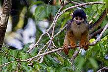
Mamirauá hosts a large diversity of birds, with more than 400 species recorded, including toucans, harpy eagle, hoatzin, 15 species of parrots and, specially, aquatic birds. Two species of monkeys, the white uakari and the black squirrel monkey are endemic of this region, which is also home of other kinds of arboreal mammals such as howler monkeys, sloths, coati and collared anteaters. Land mammals are not that common as most of the territory is flooded during the wet season. During this season the pink dolphin can be found in the flooded forest.
The most conspicuous of the numerous fish species are tambaqui, piranha and pirarucu. Mamirauá is also a perfect place to spot the Amazon river dolphins, both boto and tucuxi.
References
- ↑ "Mamirauá State Sustainable Development Reserve". protectedplanet.net.
- ↑ "Peering at the future". The Economist. 17 June 2004.
- ↑ RDS Mamirauá – ISA, Informações gerais.
- 1 2 RDS Mamirauá – ISA, Informações gerais (mapa).
- 1 2 Central Amazon Conservation Complex – UNESCO.
- ↑ CEC Central da Amazônia – ISA, Áreas relacionadas.
Sources
- CEC Central da Amazônia (in Portuguese), ISA: Instituto Socioambiental, retrieved 2016-10-17
- Central Amazon Conservation Complex, UNESCO, retrieved 2016-05-05
- RDS Mamirauá (in Portuguese), ISA: Instituto Socioambiental, retrieved 2016-10-21
Further reading
- Koziell, Izabella; Inoue, Christina Y. A. (2002). Mamirauá Sustainable Development Reserve, Brazil. IIED. ISBN 1-84369-241-4.
- Bannerman, Matt; Marigo, Luiz Claudio; Azevêdo, Aline Da Rin P. (2001). Mamirauá: A Guide to the Natural History of the Amazon Flooded Forest. Instituto de Desenvolvimento Sustentável Mamirauá. ISBN 85-88758-02-4.