Maltese patrol boat P29
 The wreck of P29 | |
| History | |
|---|---|
| Name: | Boltenhagen (GS09) |
| Builder: | Peenewerft shipyard |
| Laid down: | 8 October 1969 |
| Launched: | 22 May 1970 |
| Commissioned: | 19 September 1970 |
| Decommissioned: | 1990 |
| Fate: | Transferred to Germany, 1990. |
| Name: | Boltenhagen (BG31) |
| Acquired: | 1990 |
| Decommissioned: | 30 June 1996 |
| Fate: | Sold to Malta, 1997. |
| Name: | P29 |
| Acquired: | 24 July 1997 |
| Decommissioned: | 2004 |
| Fate: | Scuttled as artificial dive site, 14 August 2007 |
| General characteristics | |
| Class and type: | Kondor I |
| Displacement: | 361 tons |
| Length: | 51.98 metres (170 ft) |
| Beam: | 7.12 metres (23.4 ft) |
| Draft: | 2.3 metres (7.6 ft) |
| Propulsion: | MD 40 diesel engines |
| Speed: | 20 knots |
| Complement: | 20 |
| Armament: | 1 quad 14.5 mm |
Boltenhagen (GS09) was a Kondor I-class minesweeper built in East Germany. After the Volksmarine was disbanded just before the reunification of Germany, she was sold to Malta in 1997 and renamed P29 and was used as a patrol boat. After being decommissioned, she was scuttled as a dive site in 2007 off Ċirkewwa.
History
East Germany
The minesweeper was laid down on 8 October 1969 at Peenewerft shipyard in Wolgast. She was launched on 22 May 1970 and commissioned on 19 September of that same year. She was the eighteenth ship to be built within the Kondor I class, and was named Boltenhagen after the town of the same name in Rostock. She was used to patrol the river banks between East and West Germany, as well as a minesweeper.
Germany
After the reunification of Germany, the minesweeper was decommissioned along with most of the Kondor I-class. However, it was then used as a patrol vessel by the German Federal Coast Guard. The name Boltenhagen was retained but she was given the pennant number BG31.[1] The ship's guns were dismantled, the radio and radar equipment was changed, and it was repainted. BG31, the last Kondor-I in the German Coast Guard, was decommissioned on 30 June 1996.[2]
Malta
The former minesweeper was then purchased by Malta on 24 July 1997 and was given the pennant number P29. She rejoined her sister ships Ueckermünde and Pasewalk which were purchased by Malta back in 1992 and were given the pennant numbers P30 and P31. P29 became a patrol boat within the Offshore Command of the Maritime Squadron of the Armed Forces of Malta. Since the former minesweepers were purchased unarmed, some light armament was then added by the AFM.[3]
P29 was then used to secure the Maltese coast against smuggling and border control operations. She was decommissioned in 2004 and was bought by the Malta Tourism Authority in September 2005. She was cleaned and then was scuttled on 14 August 2007 off the port of Ċirkewwa to serve as a diving site and artificial reef.[4]
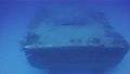
Wreck
The wreck now lies at a depth of around 35 metres but the entire dive may be done at 25 metres. The highest point is situated only 12 metres deep from the surface. Since it was quite recently sunk compared to the MV Rozi and other wreck sites in Malta, it requires some time to attract a good amount of marine life inside and around it. However, since its sinking, Alicia mirabilis, squid, flying gurnards and rays have already started settling on the former patrol boat.
In 2013, P29 was listed among the "10 Most Incredible Sunken Ships on Earth" by Amazing Beautiful World, although this list has been disputed.[5][6]
 The stern
 The superstructure
 Commemorative plaque to Frank Pembridge
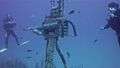 Machine gun
See also
| Wikimedia Commons has media related to P29 (ship, 1970). |
References
- ↑ Nordenberg, Per. "List of transfers". Die-Marine.de. Retrieved 16 October 2014.
- ↑ Kieschnick, Peter. "Minensuch und Räumschiff Projekt 89.1". Parow-info.de. Retrieved 16 October 2014.
- ↑ "P29 Patrol Boat". Professional Diving Schools Association. Retrieved 9 September 2014.
- ↑ "Another wreck off Cirkewwa". Times of Malta. 15 August 2007. Retrieved 9 September 2014.
- ↑ "10 Most Incredible Sunken Ships on Earth - #5 P29, Malta". Amazing Beautiful World. Retrieved 9 September 2014.
- ↑ "P29 vessel wreck among 'most amazing sunken ships on earth'". The Malta Independent. 13 September 2013. Retrieved 9 September 2014.
| Shipwrecks |
|
|---|---|
| Other incidents |
|
2006 | |
Coordinates: 35°59′16″N 14°19′43″E / 35.98778°N 14.32861°E