Maligrad
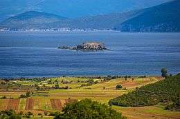 Maligrad Island on Lake Prespa | |
| Geography | |
|---|---|
| Location | Prespa Lake |
| Coordinates | 40°47′31″N 20°55′59″E / 40.79194°N 20.93306°E |
| Area | 0.05 km2 (0.019 sq mi) |
| Highest elevation | 860 m (2,820 ft) |
| Administration | |
|
Albania | |
Maligrad or Qyteti i Vogël is an island situated deep within the Albanian part of Lake Prespa, with many caves suitable for wildlife and a circular cliff.[1] Shaped like a tadpole, it contains some trees and an area of sand. The island contains a famous Saint Mary Church, built by Kesar Novak (Qesar Novaku), a local noble, in 1369.[2] It has an area of almost 5 hectares.
See also
References
Islands of Albania | |
|---|---|
| Sea | |
| Lake | |
| River | |
This article is issued from Wikipedia - version of the 11/3/2016. The text is available under the Creative Commons Attribution/Share Alike but additional terms may apply for the media files.