Malamir Knoll
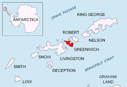


Malamir Knoll (Malamirova Mogila \ma-la-'mi-ro-va mo-'gi-la\) rises to 200 m in the southeast extremity of the Dryanovo Heights, Greenwich Island in the South Shetland Islands, Antarctica. It has precipitous and ice-free southwest slopes and was named after the Bulgarian ruler Khan Malamir, 831-836 AD.
The knoll is located at 62°30′10″S 59°48′13″W / 62.50278°S 59.80361°WCoordinates: 62°30′10″S 59°48′13″W / 62.50278°S 59.80361°W, which is 2.37 km east of Tile Ridge, and 2.9 km northeast of Triangle Point, 2.65 km north-northwest of Spit Point and 3.78 km west by south of Labbé Point (Bulgarian topographic survey Tangra 2004/05 and mapping in 2005 and 2009).
Maps
- L.L. Ivanov et al. Antarctica: Livingston Island and Greenwich Island, South Shetland Islands. Scale 1:100000 topographic map. Sofia: Antarctic Place-names Commission of Bulgaria, 2005.
- L.L. Ivanov. Antarctica: Livingston Island and Greenwich, Robert, Snow and Smith Islands. Scale 1:120000 topographic map. Troyan: Manfred Wörner Foundation, 2009.
References
This article includes information from the Antarctic Place-names Commission of Bulgaria which is used with permission.