Malabadi Bridge
| Malabadi Bridge | |
|---|---|
 | |
| Coordinates | 38°09′13″N 41°12′13.8″E / 38.15361°N 41.203833°ECoordinates: 38°09′13″N 41°12′13.8″E / 38.15361°N 41.203833°E |
| Crosses | Batman River |
| Locale | Near Silvan, Diyarbakır Province, Eastern Anatolia Region, Turkey |
| Characteristics | |
| Design | Pointed arch bridge |
| Material | Stone |
| Total length | 150 m (160 yd) |
| Width | 7 m (23 ft) |
| Height | 19 m (62 ft) |
| Longest span | 38.6 m (127 ft) |
| Number of spans | 1 |
| History | |
| Construction begin | AH 541 (1146/1147) |
| Construction end | AH 548 (1153/1154) |
 Malabadi Bridge Location of the Malabadi Bridge | |
The Malabadi Bridge (Turkish: Malabadi Köprüsü, Kurdish: Pira Malabadê) is an arch bridge spanning the Batman River near the town of Silvan in southeastern Turkey. Construction began in the year AH 541 (1146/1147) during the Artuqid period, and appears to have been completed in AH 549 (1154/1155).[1] The bridge was commissioned by Temür-Tash of Mardin, son of Ilghazi, and grandson of Artuk Bey.
According to the local 12th-century historian Ibn al-Azraq al-Farīqī, the current bridge replaced one built in AH 48 (668/669) that had collapsed in AH 539 (1144/1145).[2] Inconsistencies between the two surviving manuscript copies of Ibn al-Azraq's account make it difficult to definitively identify the Malabadi bridge as the one he refers to as the Qaramān or Aqramān bridge.[3] Nevertheless, many aspects of his geographical description and historical account support this identification.[3]
Ibn al-Azraq says that construction of the current bridge was initiated by the Artuqid ruler of Mayafaraqin and Mardin al-Saʿīd Ḥusām al-Dīn Temür-Tash in AH 541 (1146/1147), under the supervision of al-Zāhid bin al-Ṭawīl.[4] After al-Zāhid had built the bridge's eastern footing it was destroyed by floods.[4] Al-Zāhid was fined for "defective craftsmanship" and replaced by Amir Saif al-Dīn Shīrbārīk Maudūd bin ʿAlī (bin Alp-Yaruq) bin Artuq.[5] Shīrbārīk restarted the work under the supervision of Abuʾl-Khair bin al-Ḥakīm al-Fāsūl, who used massive timbers in the construction.[4] By AH 548 (1153/1154) the bridge was nearly finished.[6] And yet, at the time of the death of Ḥusām al-Dīn Temür-Tash on 2 Dhuʾl-Qaʿda 548/18 January 1154, the arch was not yet complete.[7][8] His successor, Najm al-Dīn Alpī, set about completing the bridge, and, although work was again interrupted by flooding, "[h]e built and repaired it and completed the joining of the arch."[1]
The French architectural historian Albert Gabriel and epigraphist Jean Sauvaget visited the bridge in 1932 and Sauvaget discerned an inscription in the name of Temür-Tash with the year AH 542 (1147/1148), which possibly corresponds to the start of the second construction under Shīrbārīk.[9]
The bridge was restored in the late twelfth century, and recently in the beginning of the 20th century. It was once the only bridge across the river in this area, and was in continuous use until the 1950s, when a new road bridge was opened upstream.
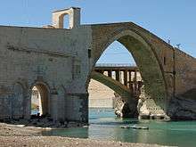
The span of the bridge crosses perpendicular to the river, but the roadway is at an angle to the river, so there are angular breaks in the east and west approaches. The approaches rise from ground level to meet the central span, which is a pointed arch high over the deepest part of the river. Constructed from colored solid masonry, the approaches have small arches built into them to let flood-waters through. Two of the piers of the bridge sit in the river; the western support is decorated with two carved figures, one standing and one sitting. The bridge is 150 m (160 yd) long and 7 m (23 ft) wide, 19 m (62 ft) in height and a main span of 38.6 m (127 ft).[10] The roadway has two toll-booths, one either side of the main span. The spandrels of the main arch incorporate small rooms for weary travelers.
References
- 1 2 Hillenbrand 1979, pp. 445–447.
- ↑ Hillenbrand 1979, p. 314.
- 1 2 Hillenbrand 1979, pp. 445–446.
- 1 2 3 Hillenbrand 1979, p. 317.
- ↑ Hillenbrand 1979, pp. 317,549.
- ↑ Hillenbrand 1979, p. 549.
- ↑ Hillenbrand 1979, pp. 446–447.
- ↑ Hillenbrand 1979, p. 560.
- ↑ Gabriel 1940, p. 236.
- ↑ Doğangün & Ural 2007, p. 183.
Sources
| Wikimedia Commons has media related to Malabadi Bridge. |
- Doğangün, A; Ural, A (2007). Characteristics of Anatolian stone arch bridges and a case study for Malabadi bridge (PDF). ARCH’07: 5th International Conference on Arch Bridges. pp. 179–186. Retrieved 2 January 2014.
- Gabriel, Albert (1940), Voyages archéologiques dans la Turquie orientale [Archeological Travels in Eastern Turkey] (in French)
- Hillenbrand, Carole (1979). The History of the Jazīra 1100-1150: the contribution of Ibn Al-Azraq al-Fāriqī (Ph.D. thesis). Edinburgh University. p. 314, 317, 444, 445–447, 500, 549.