Thomas Mitchell (explorer)
| Major Sir Thomas Mitchell | |
|---|---|
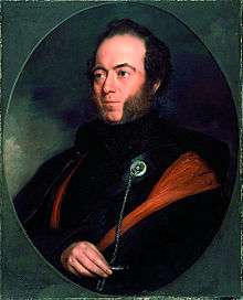 Portrait of Major Sir Thomas Mitchell (c. 1830s) | |
| Born |
Thomas Livingstone Mitchell 15 June 1792 Grangemouth, Scotland |
| Died |
5 October 1855 (aged 63) Sydney, Australia |
| Cause of death | Bronchitis |
| Resting place | Camperdown Cemetery, Newtown, New South Wales, Australia |
| Nationality | Scottish |
| Education | Doctor of Civil Law |
| Alma mater | Oxford University |
| Occupation | Surveyor, explorer |
| Known for | Explorations of south-eastern Australia, Wyld's Atlas |
| Title | Lieutenant colonel Sir |
| Spouse(s) | Mary Blunt |
| Children | 12 |
| Parent(s) | John Mitchell, Janet, née Wilson |
| Awards | Knighthood |
_exploration_map.svg.png)

Lieutenant Colonel Sir Thomas Livingstone Mitchell (15 June 1792 – 5 October 1855), surveyor and explorer of south-eastern Australia, was born at Grangemouth in Stirlingshire, Scotland.[1] In 1827 he took up an appointment as Assistant Surveyor General of New South Wales. The following year he became Surveyor General and remained in this position until his death. Mitchell was knighted in 1839 for his contribution to the surveying of Australia.[1][2]
Early life
Born in Scotland on 15 June 1792, he was son of John Mitchell of Carron Works and was brought up from childhood by his uncle, Thomas Livingstone of Parkhall, Stirlingshire.[3] On the death of his uncle, he joined the British army in Portugal as a volunteer, at the age of sixteen. On 24 June 1811, at the age of nineteen, he received his first commission as 2nd Lieutenant in the 1st Battalion 95th Rifles (later the Rifle Brigade / Royal Green Jackets). Utilising his skills as a draughtsman of outstanding ability, he was occasionally employed in the Quartermaster-General’s department under Sir George Murray. He was present at the storming of the fortresses of Ciudad Rodrigo, Badajos and San Sebastian as well as the battles of Salamanca and the Pyrenees. Subsequently he would receive the Military General Service Medal with bars for each of these engagements. When the war was over Murray obtained permission from the Treasury for an officer to reside in Spain and Portugal for four years to complete the sketches of the battlefields which had been begun during the war for the Military Depot.[4] Lieutenant Mitchell, was selected as a person well qualified in every respect to aid in the accomplishment of the undertaking. The first duty allotted to him was the completing of such sketches, begun during the war, as had remained unfinished, and adding to these several other important surveys, for the execution of which it had been impossible to allot officers whilst operations were in progress in the field. But in the summer of 1819 the continuance of the disbursements made by Government for the undertaking became doubtful, so he was called home. He then devoted himself to the second part of his task, which was that of making finished drawings from the materials complied by himself, and from other documents of ascertained authenticity. But with the cessation of the Government allowances he had to stop this work.
On 10 June 1818, during his posting in Spain and Portugal, he married Mary Blunt (daughter of General Richard Blunt)[2] in Lisbon and gained promotion to a company in the 54th Regiment.[5] With the reductions in the military establishment of the country which followed the withdrawing of the Army of Occupation from France, Captain Mitchell was placed on half-pay.
It was not until a lapse of several years, whilst Mitchell was in London between 1838 – 1840, that the work was completed. The finished drawings were published, by the London geographer James Wyld, in 1841. Wyld’s Atlas containing the principle battles, sieges and affairs of the Peninsular War, together with a Memoir annexed to it, consisted of a text of the movement orders prepared at the same time by Murray. Of almost unimpeachable accuracy, it is the prime source for the topography of the war.[6]
In 1827, with the support of Sir George Murray, Mitchell became Assistant Surveyor General of New South Wales with the right to succeed John Oxley. Oxley died the following year, and on 27 May 1828, Mitchell became Surveyor General.[2] In this post he did much to improve the quality and accuracy of surveying – a vital task in a colony where huge tracts of land were being opened up and sold to new settlers. One of the first roads surveyed under his leadership was the Great North Road, built by convict labour between 1826 and 1836 linking Sydney to the Hunter Region. The Great South Road (now replaced by the Hume Highway), also convict-built, linked Sydney and Goulburn. He kept a record of his 'Progress in roads and Public Works in New South Wales to 1855',[7] including sketches and plans of Sydney, Emu Plains, the Blue Mountains, Victoria Pass, roads to Bathurst, Wiseman's Ferry, and indigenous Australians.[8]
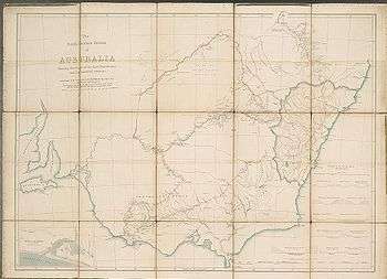
As Surveyor General, Mitchell also completed maps and plans of Sydney, including Darling Point,[9] Point Piper,[10] the city,[11] and Port Jackson.[12] In 1834 he was commissioned to survey a map of the Nineteen Counties. The map he produced was done with such skill and accuracy that he was awarded a knighthood.[13]
First expedition
In 1831 a runaway convict George Clarke, who had lived with aborigines in the area for several years, claimed that a large river called Kindur flowed north-west from the Liverpool ranges in New South Wales to the sea. Charles Sturt believed that the Murray-Darling system formed the main river system of New South Wales and Mitchell wanted to prove Sturt wrong. Mitchell formed an expedition consisting of himself, assistant surveyor George Boyle White and 15 convicts who were promised remission for good conduct. Mitchell took 20 bullocks, three heavy drays, three light carts and 9 horses for supplies and transport, and set out on 24 November 1831 to investigate the claim. On reaching Wollombi in the Hunter Valley, the local assistant surveyor Heneage Finch expressed a desire to join the expedition. He had established his credentials by surveying a route from Sydney to Wollombi, so Mitchell approved his request provided he obtained extra supplies and men, and followed along later.
The expedition continued northward, climbed the Liverpool Range on 5 December, and made Quirindi on 8 December. Shortly afterwards Finch arrived but inexplicably had not brought provisions, so Mitchell immediately sent him back to get them. By 11 December the expedition had reached Wallamoul Station near Tamworth, the northern extent of white settlement at the time.
Mitchell continued his northward push into new territory, taking local aboriginal guides of the Kamilaroi people to assist in finding water and to express his peaceful intentions. In early January 1832 he was in the vicinity of the present town of Narrabri, reached the Gwydir River in mid-January and found the Barwon by the end of the month where he set up camp. Mitchell left the main party and made a reconnaissance down the Barwon until he found its junction with the Gwydir. After Mitchell rejoined the main camp, Finch arrived with tragic news. He had been travelling with three convicts and provisions but because of a shortage of water, had separated leaving two men behind while he attempted to locate the main expedition. This he failed to do, and on the second day returned to discover that the campsite had been ransacked, supplies scattered and beneath the wreckage were two dead men. The immediate effect was that Mitchell decided to abandon the expedition and return south. The party reached the Gwydir on 8 February and was near the site of the attack on 17 February. Mitchell buried the two bodies, salvaged some equipment and once back at Wallamoul, placed White in charge of the main party, while Mitchell returned hastily to Sydney. He was satisfied that there was no truth about a river Kindur claimed by Clarke. Fourteen years after the attack, Mitchell revealed that the convicts had indulged in sexual relations with aboriginal women.
Second expedition
Mitchell's next expedition was in 1835. The purpose was to explore the path of the Darling River from where Sturt had turned back in 1829, to where it joined the Murray River. There were 21 men in the party, with James Larmer (assistant surveyor) as second in command, Richard Cunningham (colonial botanist) and 18 other men. The main party under Larmer left Sydney on 6 April to rendezvous with Mitchell at Boree near the township of Orange. The expedition passed quickly into territory known to be occupied by Wiradjuri people as Mitchell made his way along the south bank of the Bogan River. On 17 April 1835, Richard Cunningham wandered away from the party while looking for botanical specimens. Some hours later, he was reported missing. The party halted and frantically searched for 12 days, coming across his horse that had died with the saddle still on. They followed Cunningham's tracks along the Bogan for 20 miles until they disappeared near an encampment of aborigines. At the camp they found the skirt of Cunningham's coat and fragments of a map he was carrying. His fate was not known until the expedition had returned.
After a fruitless search for Cunningham, Mitchell decided to continue the expedition. He followed the Bogan River downstream, sometimes employing aboriginal guides, with the usual payment being a Tomahawk. After several days and about 50–60 miles of travel, a brief confrontation between a member of the party and an aborigine resulted in the aborigine being wounded by shotgun pellets. He survived, and his wounds were dressed at a tent, after which he left. The Darling River was reached at the end of May and the expedition continued for about 12 miles down the left bank. Mitchell decided to build a fort for safety while allowing time for the animals to refresh. He named the location Fort Bourke in honour of the Governor, Richard Bourke. Two whale boats had been transported the whole distance on the bullock drays, so on 1 June Mitchell launched the boats on the Darling to transport the party down river. However, the river became shallower and unnavigable downstream resulting in the expedition resorting once again to overland progress.[14] On 8 June the expedition departed Fort Bourke once again, encountering many tribes as they headed south, and by 15 June were 90 miles from the fort. One tribe appeared more hostile than others, kicking up dust and spitting at party members when they were retrieving water from the river. Mitchell and party were just north of Menindee on 9 July, and while camped for three days, noticed several tribes congregating which he took to be premeditated. He was planning on splitting the party to advance down the Darling faster, but he assessed the situation as becoming dangerous and decided instead to keep the men together and return to Sydney. Mitchell noted that just after he communicated to the party his decision to retreat, they heard shots from a forage party up the river. Following a brief skirmish, at least three aborigines had been killed, including a woman and her child. One of the members of the expedition had been knocked unconscious. On 14 July, the party commenced their return via the outbound route. Mitchell decided to avoid contact with the various tribes as much as possible on their return. They were at the Fort Bourke on 10 August and Peak Hill, close to the frontier, on 9 September where they learned from station stockmen of the death of Cunningham. When back in Sydney, Mitchell added some passages which were not in his journal that seemed to implicate some of his men in the deadly incident near Menindee.
While Mitchell did not trace the Darling River to its junction with the Murray River, the course and terrain of the Bogan River and 483 km of the Darling River had been charted.[15] The place where Cunningham was killed is marked on an 1836 map by Mitchell, showing the positions of exploring parties when most assailed by aborigines.[16]
Third expedition

The goal of Mitchell's third expedition was to explore and survey the lower part of the Darling River, with instructions to head up the Murray River and return to Sydney via the settled areas around Yass. Second in command was assistant surveyor Granville Stapylton, and 23 convicts made up the rest of the party. He set out on 17 March 1836, and when passing Bathurst engaged a Wiradjuri aboriginal guide, John Piper. Mitchell made his way to Boree and the Bogan River as on previous journeys, then veered south to the Lachlan River to approach the Darling from its southern end where it joined the Murray.
The party travelled along the Lachlan, passing Condobolin and Lake Cargelligo, both found by John Oxley in 1817. Piper was able to converse with tribes to learn where vital waterholes were, as the Lachlan was drying out. On 2 May an aboriginal widow named Turandurey with her four-year-old daughter Ballandella from the Muthi Muthi tribe joined the expedition as a guide. She remembered Oxley from nineteen years earlier and Sturt as well, and knew the lower Lachlan. The Murrumbidgee River was reached on 12 May, but at a point downstream from the junction with the Lachlan.
The party camped while Mitchell took five men and went upstream to find the junction. Once found, they turned about and continued down the Murrumbidgee until 21 May when they were close to the junction with the Murray River. A depot was established at this point, so Mitchell left Staplyton and eight men to guard the stock, while he ventured downstream with fifteen men. On 24 May Mitchell noticed that Barkindji tribesmen from the Darling River were gathering in large numbers, and by 27 May the hostile intentions of these men became known, when local Murray River people told Piper that the Barkindji were planning to kill Mitchell and his men. Mitchell had to decide whether to wait for an attack, or plan a pre-emptive manoeuvre. His numbers were reduced, as Staplyton and eight men were still at the depot. He split his party again, leaving half the men to hide in the scrub in ambush, while he continued ahead with the carts. When the armed Barkindji warriors approached, the convict Charles King, who was involved in the earlier killings, fired without waiting for orders. The tribesmen ran, but in the ensuing skirmish many shots were fired killing seven aborigines and wounding four. Mitchell wrote about the loss of life in his journal, describing the Barkindji as "treacherous savages", and detailing how his men had chased them away, "pursuing and shooting as many as they could."[17] This section was withheld from Mitchell's report when it was released to the public in Sydney.[18][19] The report indicated that Mitchell and his men had been taken by surprise.
The expedition continued and on 31 May they reached the junction of the Darling and Murray rivers. Mitchell travelled up the eastern side of the Darling for some distance, and when he was certain that it was the same river he had explored in 1835, he turned back and headed upstream on the Murray to join Stapylton at the depot. The reunited expedition now travelled south-east following the Murray, crossed the river on 13 June and named Swan Hill on 21 June. At the end of June the country had improved considerably, so Mitchell chose to leave the Murray to investigate better looking lands to the south-west. Upon climbing the 300 foot Pyramid Hill, he was so impressed with the country he saw, he named it Australia Felix. In early July the party crossed the Loddon River, and made their way in a south-westerly direction which brought them to the Grampians, and later to the mouth of the Glenelg River on the coast. It was now August, so Mitchell altered direction towards Portland and the south-east. When Portland was reached on 29 August, Mitchell was surprised to find an established farm manned by the Henty brothers, Edward and Frank. There were several whaling boats on Portland Bay as well.
After a brief sojourn, the expedition commenced the return to Sydney in a north-easterly direction, meeting few aborigines on the way, though they were aware of being watched. On 17 September, in order to speed his return, Mitchell split the party in two once more taking 14 men with him, and leaving the remainder with Stapylton to follow with the bullocks and drays. The young girl Ballandella went with Mitchell, while Turandurey remained with the rear party. On 30 September, Mitchell climbed and named Mount Macedon, from the summit of which he had a view of Port Phillip. Progress was slow due to wet ground, and the Murrumbidgee was not reached until 24 October. When Mitchell arrived in Sydney in early November he was received with great joy. However, when the remainder of his party arrived two weeks later, rumours circulated about the mass killing on the Murray. He subsequently faced a Legislative Council Inquiry in December 1836, receiving an official rebuke. Ballandella joined Mitchell's family of eight other children and learnt to read and write.
Fourth expedition
Mitchell's fourth expedition was into Queensland in 1845-46. He was convinced that a significant river must flow north-west into the Gulf of Carpentaria, this being the main thrust of the endeavour.[20]
On 15 December 1845 Mitchell started from Boree (Buree in Mitchell's journal) with a large party including Edmund Kennedy as second in command (later speared to death at Escape River near Cape York). He struck the Darling River above Fort Bourke then continued to the Narran River, the Balonne, and the Culgoa. On 12 April 1846 he came to a natural bridge of rocks on the main branch of the Balonne which he called St.George Bridge, now the site of the town of St George. Kennedy was left in charge of the main body here, and was instructed to follow on slowly while Mitchell pushed ahead with a few men. Mitchell followed the Balonne to the Maranoa, and the Cogoon (now called Muckadilla Creek, near Roma). This rivulet led him to a magnificent pastoral district in the midst of which stood a solitary hill that he named Mount Abundance. He then crossed a low watershed to the Maranoa and awaited Kennedy's arrival. Kennedy rejoined Mitchell on 1 June 1846.[20]
Leaving Kennedy for a second time, he set out on an extensive excursion of more than four months.[21] Mitchell traversed the country at the head of the Maranoa and discovered the Warrago River. Keeping north over the watershed, he traversed the Claude and Nogoa rivers, then reached the Belyando River, an upper reach of the Burdekin River.[20] This had already been discovered by Ludwig Leichhardt on his expedition to Port Essington on 2 April 1845. Intensely mortified to find that he was on a tributary of the Burdekin River, and approaching the ground already trodden by Leichhardt, he returned to the head of the Nogoa and struck west, after dividing his party and forming a stationary camp. He continued west, making a new discovery which he was certain was the fabled north-west river. In honour of the sovereign of the time he decided to call it Victoria River.[20] Having run out of time, he turned back towards the main party. It was here that Mitchell first noticed the well known grass that bears his name. On the homeward journey he trekked along the Maranoa River to St.George Bridge, arriving in Sydney 20 January 1847.[22] Later that year, Kennedy proved beyond doubt that the Victoria did not continue north-west, but turned south-west and joined Cooper Creek. He renamed the watercourse the Barcoo River from a name mentioned by local Aborigines.[20]
Later career

In 1837, Mitchell sought 18 months leave from his position and in May he left Sydney for London. During his leave, he published an account of his explorations called Three Expeditions Into the Interior of Eastern Australia: with descriptions of the recently explored region of Australia Felix, and of the present colony of New South Wales.[23] Mitchell sought additional periods of leave and finally arrived back in Australia in 1841. Mitchell left Sydney again in March 1847 on another period of leave. By the time he arrived back in mid-1848, he had published his Journal of an Expedition into the Interior of Tropical Australia, in search of a route from Sydney to the Gulf of Carpentaria.[1]
Mitchell's journals proved a rich source for historians and anthropologists, with their close and sympathetic observations of the Aboriginal peoples he had encountered. These publications made him the most celebrated Australian explorer of his day. But he was a difficult man to get on with, made evident by this passage made by Governor Charles Augustus FitzRoy:
"It is notorious that Sir Thomas Mitchell's unfortunate impracticability of temper and spirit of opposition of those in authority over him misled him into frequent collision with my predecessors."
In a by-election for the Electoral district of Port Phillip in April 1844, Mitchell was elected to the New South Wales Legislative Council.[2] He found it difficult to separate his roles of government employee and elected member of the legislature, and after only five months he resigned from the Legislative Council.[1][2]
Mitchell is also remembered as the last person in Australia to challenge anyone to a duel. In September 1851, Mitchell issued a challenge to Sir Stuart Alexander Donaldson because Donaldson had publicly criticised excessive spending by the Surveyor General's Department. The duel took place in Sydney on 27 September with both duellists missing their marks.[24] The French 50 calibre pistols used in the duel are in the collection of the National Museum of Australia.[25]
Ophir gold fields
In 1851, Mitchell was instructed by Governor FitzRoy to make a report on, and survey of, 'the extent and productiveness of the goldfield reported to have been discovered in the County of Bathurst.'[5][26] He travelled west during winter to visit the Ophir gold diggings, accompanied by his son, Roderick, and Samuel Stutchbury the government geologist.[26]
In June 1851 Mitchell selected the site for the township of Ophir. W.R. Davidson plotted a survey of the ground and Mitchell planned the streets and allotments for the town.[27]
Mitchell returned with a collection of specimens from the diggings, mostly quartz, with 48 of these stored in a wooden chest[28] His report of the goldfields was presented to the Legislative Council in February 1852.[5]
Story of the "bomerang" propeller
The search for a method of screw propulsion of ships intrigued many inventors during the latter half of the 18th century and the beginning of the 19th. An Englishman, K. P. Smith, patented a screw propeller in 1836, and shortly afterwards Captain John Ericsson, formerly an officer of the Swedish army, patented another.
On his travels, Mitchell must have been evolving the idea of his boomerang propeller—he spelled it "bomerang", while newspapers used "bomarang" and "boomerang." The first test was made In the Sydney Harbour in May, 1852, an iron propeller being fitted to the "screw-steamer" Keera. The results of this trial were considered satisfactory, the ship's progress being calculated on two runs at 10 and a little over 12 knots,[29] and Sir Thomas Mitchell took his Invention to England. In 1853 the propeller was fitted to the Genova, and a trial was conducted on the Mersey. Then the Admiralty gave it a test on HMS Conflict. The Genova ran at 9.5 knots as against 8.5 with a screw propeller, and the Conflict 9.25 knots as against the screw propeller 8.75, and at a lower engine speed. The "boomerang" propeller can be simply described as a "screw" propeller with much of the blades close to the shaft, which contribute little to propulsion but much to drag, cut away,[30] a principle which is well understood today.
Family life
Thomas Mitchell and Mary had twelve children: Livingstone, Roderick, Murray, Campbell, Thomas, Richard, Georgina, Maria, Emily, Camilla, Alicia, Blanche.[5] Georgina and Maria died young, and Murray before 1847. Roderick and Campbell died during the last years of Mitchell's life.[5]
His family enjoyed a privileged upbringing, and Blanche Mitchell, his youngest daughter, recorded her daily activities and social life in childhood diaries and notebooks.[31] Her sister Emily married George Edward Thicknesse-Touchet, 21st Baron Audley.
In 1841, Mitchell completed his new Gothic home, Carthona, on the water's edge in Darling Point, Sydney.[31] Following Mitchell's death, his family moved to Craigend Terrace in Woolloomooloo.[31]
Death

In July 1855 a Royal Commission was appointed to inquire into the New South Wales Survey Department. Before its report was published, Mitchell contracted a chill while surveying the line of road between Nelligen and Braidwood. He developed a severe attack of bronchitis and died a few days later at Carthona at Darling Point at 5:15pm 5 October 1855.[32] Newspapers of the day commented:
"For a period of twenty-eight years Sir Thomas Mitchell had served the Colony, much of that service having been exceedingly arduous and difficult. Among the early explorers of Australia his name will occupy an honoured place in the estimation of posterity."
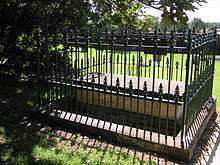
He is buried at Camperdown Cemetery, Newtown, with his grave being maintained by the Seniors Group of Surveyors.[33]
Naming
Some of the places Mitchell named on his expeditions were: the Avoca River, Balonne River, Belyando River, Campaspe River, Cogoon River, Discovery Bay, Glenelg River, Grampians, Maranoa River, Mount Arapiles, Mount King, Mount Macedon, Mount Napier, Mount William, Nyngan, Pyramid Hill, St George, Swan Hill and Wimmera River.
Commemoration
Because of his contributions in the surveying and exploration of Australia, Mitchell is commemorated by having numerous localities or objects across Australia being named after him. These include:
- The town of Mitchell in Queensland[34]
- The Mitchell River in Queensland [35]
- The Canberra suburb of Mitchell
- The electorate of Mitchell[36]
- The Mitchell Highway
- The Major Mitchell's cockatoo, a species of cockatoo[37]
- Steam locomotive number S 301 Sir Thomas Mitchell, a member of the Victorian Railways S class locomotives.[38] In turn, Mitchell House at Seymour Technical High School, the town with the loco depot which serviced the famous four locos. Later, the name was carried by the diesel S301.
- Mitchell grass, common name of the small genus of grass species dominant across much of the arid areas of the continent
- Mitchell's hopping mouse, an Australian native rodent-like animal
- A local government area in Victoria, Shire of Mitchell
- Countless roadside locations in Victoria have a memorial erected 'Major Mitchell passed here'.
Mitchell is also the namesake in the highest honour of the New South Wales Surveyors Awards, the Sir Thomas Mitchell Excellence in Surveying Award.
See also
- Charles Sturt
- Great North Road (Australia)
- History of New South Wales
- New South Wales gold rush
- Nineteen Counties
- Surveyor General of New South Wales
References
- 1 2 3 4 Baker, D. W. A. "Mitchell, Sir Thomas Livingstone (1792–1855)". Australian Dictionary of Biography. Australian National University. Retrieved 22 October 2011.
- 1 2 3 4 5 "Sir Thomas Livingstone MITCHELL (1792 - 1855)". Former Members Index A-Z. NSW Government. Retrieved 23 May 2013.
- ↑ "Sir Thomas Livingstone Mitchell.". Australian Town and Country Journal. NSW: National Library of Australia. 14 December 1878. p. 17. Retrieved 31 January 2012.
- ↑ Depot of Military Knowledge, Britain’s first central organisation for the collection, preservation and dissemination of military intelligence (including the collection, preparation and copying of maps), was created in 1803 by the Duke of York. During the war a branch was set up in Lisbon.
- 1 2 3 4 5 Cumpston, J.H.L. "Thomas Mitchell – Surveyor General and Explorer". Retrieved 22 October 2011.
- ↑ UK National Archives, Kew : file reference WO 78/5800, in 4 folders & 1 roll file
- ↑ Mitchell, Thomas. "Sir Thomas Livingston Mitchell papers, 1827-1855". State Library of New South Wales. Retrieved 12 December 2013.
- ↑ Mitchell, Thomas. "Illustrations from Progress in Public Works & Roads in NSW 1827-1855". State Library of New South Wales. Retrieved 12 December 2013.
- ↑ Mitchell, Thomas. "Plan of Mrs. Darling's Point divided into villa allotments for sale, 1833". State Library of New South Wales. Retrieved 12 December 2013.
- ↑ Mitchell, Thomas. "The Estate of Point Piper, surveyed trigonometrically and divided into allotments, [1844?]". State Library of New South Wales. Retrieved 12 December 2013.
- ↑ Mitchell, Thomas. "Plan of the land on the east side of the northern continuation of Kent Street where the Government quarries are situated, 1833". State Library of New South Wales. Retrieved 12 December 2013.
- ↑ Mitchell, Thomas. "Trigonometrical survey of Port Jackson: commenced as a military survey by order of General Darling and continued as civil duties permitted or required, 1853". State Library of New South Wales. Retrieved 12 December 2013.
- ↑ Canberra's Engineering Heritage, William Charles Andrews, Institution of Engineers, Canberra, 1990 p1
- ↑ "INTERIOR DISCOVERY,.". The Australian. Sydney: National Library of Australia. 22 September 1835. p. 2. Retrieved 28 January 2012.
- ↑ Baker, D W A. "Mitchell, Sir Thomas Livingstone (1792–1855)". Australian Dictionary of Biography, National Centre of Biography, Australian National University. Retrieved 28 November 2013.
- ↑ Mitchell, Thomas Livingstone. "Map to shew the positions of the exploring parties in the interior of New South Wales when most assailed by the natives in 1831, 1835 and 1836". Retrieved 27 November 2013.
- ↑ Report by TL Mitchell, c. 1836, cited in Bongiorno, Frank (2009). Clune, David; Turner, Ken, eds. The Governors of New South Wales. The Federation Press. p. 177. ISBN 9781862877436.
- ↑ Joy, William (1964). The Explorers. Adelaide: Rigby Ltd. p. 49. ISBN 0 85179 112 3.
- ↑ http://trove.nla.gov.au/ndp/del/article/2207655
- 1 2 3 4 5 Beale, Edgar (1983). Kennedy The Barcoo and Beyond 1847. Hobart: Blubber Head Press. ISBN 0 908528 11 6.
- ↑ Mitchell, Thomas Livingstone. "Sketch map of the country and the routes between the Maranoa and Mount Mudge, River Victoria". Retrieved 27 November 2013.
- ↑ "SIR THOMAS MITCHELL.". Townsville Daily Bulletin. Qld.: National Library of Australia. 21 April 1945. p. 4. Retrieved 28 January 2012.
- ↑ Mitchell, Thomas. "Three expeditions into the interior of eastern Australia : with descriptions of the recently explored region of Australia Felix, and of the present colony of New South Wales". State Library of New South Wales. Retrieved 12 December 2013.
- ↑ National Museum of Australia Collections: Sir Thomas Mitchell Duelling pistols, edited essay by Johanna Parker from the Captivating and Curious publication, accessed 18 April 2011
- ↑ National Museum of Australia: Object record, Matching cased pair of French .50 calibre duelling pistols with accessories, used by Sir Thomas Mitchell in Sydney in 1851
- 1 2 "Off to the diggings: Sir Thomas Livingstone Mitchell". State Library of New South Wales. Retrieved 28 November 2013.
- ↑ Mitchell, Thomas. "Sir Thomas Mitchell diary, with comments on the discovery of gold, especially in the Bathurst district, 1851". Retrieved 28 November 2013.
- ↑ Mitchell, Thomas. "[Gold chest belonging to Thomas Livingstone Mitchell, c.1851-1855]". Retrieved 28 November 2013.
- ↑ "The Bomerang Propeller Tried in the Keera". Empire (newspaper) (431). New South Wales, Australia. 31 May 1852. p. 2. Retrieved 13 June 2016 – via National Library of Australia.
- ↑ "The Boomerang Propeller". The Sydney Morning Herald. XXXV, (5246). New South Wales, Australia. 18 March 1854. p. 4. Retrieved 13 June 2016 – via National Library of Australia.
- 1 2 3 "Looking East: Sir Thomas Mitchell". State Library of New South Wales. Retrieved 5 December 2013.
- ↑ "DEATH OF SIR THOMAS MITCHELL.". The Maitland Mercury & Hunter River General Advertiser. NSW: National Library of Australia. 10 October 1855. p. 1 Supplement: Supplement to the Maitland Mercury. Retrieved 31 January 2012.
- ↑ http://www.surveyors.org.au/__data/page/692/09-Apr.pdf
- ↑ "Mitchell".
- ↑ "Major Mitchell Expedition » About Thomas Mitchell".
- ↑ http://www.electioncandidates.com.au/new-south-wales-state-electoral-divisions/mitchell-electorate/
- ↑ "Swan Hill School". Swan Hill School.
- ↑ Bau, Mark. "S class steam locomotives". Mark Bau's VR Website. Retrieved 21 October 2011.
- ↑ IPNI. T.Mitch.
External links
| Wikimedia Commons has media related to Thomas Mitchell. |
Mennell, Philip (1892). "![]() Mitchell, Sir Thomas Livingstone". The Dictionary of Australasian Biography. London: Hutchinson & Co. Wikisource
Mitchell, Sir Thomas Livingstone". The Dictionary of Australasian Biography. London: Hutchinson & Co. Wikisource
- Works by Thomas Mitchell at Project Gutenberg
- Works by or about Thomas Mitchell at Internet Archive
- Journal of an Expedition into the Interior of Tropical Australia
- Three Expeditions into the Interior of Eastern Australia, Volume 1, Volume 2
- The Great North Road – Convict Trail Project
| Preceded by John Oxley |
Surveyor General of New South Wales 1828–1855 |
Succeeded by George Barney |
| New South Wales Legislative Council | ||
|---|---|---|
| Preceded by Alexander Thomson |
Member for Port Phillip 1844 Served alongside: Thomas Walker, Charles Nicholson, Adolphus Young, John Dunmore Lang |
Succeeded by Benjamin Boyd |