Majadahonda
| Majadahonda | |||
|---|---|---|---|
|
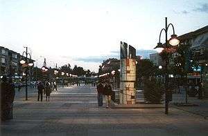
Gran Via, the pedestrianized centre of Majadahonda | |||
| |||
 Majadahonda Location of Majadahonda within Spain | |||
| Coordinates: 40°28′22″N 3°52′20″W / 40.47278°N 3.87222°W | |||
| Country |
| ||
| Region |
| ||
| Comarca | Madrid metropolitan area | ||
| Government | |||
| • Mayor | Narciso de Foxá Alfaro (PP) | ||
| Area | |||
| • Total | 38.48 km2 (14.86 sq mi) | ||
| Elevation | 743 m (2,438 ft) | ||
| Population (2010) | |||
| • Total | 69,439 | ||
| • Density | 1,800/km2 (4,700/sq mi) | ||
| Demonym(s) | Majariegos | ||
| Time zone | CET (UTC+1) | ||
| • Summer (DST) | CEST (UTC+2) | ||
| Postal codes in Spain | 28220, 28221, 28222 | ||
| Area code(s) | 34 (Spain) + 91 (Madrid) | ||
| Patron Saint | St. Catherine of Alexandria | ||
| Climate | Csa | ||
| Website | Official website | ||


Majadahonda (Spanish pronunciation: [ma.xa.ða.ˈon.da]) is a municipality in Spain, situated 16 km northwest of Madrid, in the Community of Madrid.
It lies alongside the motorway A6 Madrid-A Coruña.
The Puerta de Hierro university (public) hospital was relocated to Majadahonda from the western part of the city of Madrid into a newly built medical complex in 2009.
History
Facts surrounding the original founding of Majadahonda are not readily verifiable, although some current residents of Majadahonda believe that the founders were Segovian shepherds who, by the 13th century, were based in the area, which, being poor agricultural land, was mostly used for grazing.
According to tradition, a small village emerged as a droving station called Majadahonda. Some archaeological findings including the remains of a Roman-Visigoth town tend to support the idea that a settlement was established in the 1st century AD, before being abandoned and then recolonized.
By the 16th century Majadahonda began to become proper village with a population of about 400 inhabitants. At the end of the 16th century there were almost two hundred houses and some 800 inhabitants. Majadahonda is mentioned in Miguel de Cervantes' Don Quixote and El Buscón by Francisco de Quevedo. The centre of the village at the time was the Church of Santa Catherine, a small hospital and a modest inn. The town extended through the streets named San Roque, Calle Real and Calle Christ.
In the 17th century a dramatic reduction of population occurred. Tradition says that Majadahonda was on the verge of being sold to a private owner, as occurred at Boadilla del Monte and Pozuelo de Aravaca (which was renamed Pozuelo de Alarcón, after the sale). However, the protest of the inhabitants to Philip IV of Spain was effective and the sale was frustrated. In the 18th century a considerable population increase occurred, with some 800 inhabitants according to the census of Floridablanca. The majority of the men were day laborers, serving a minority of rich farmers and landed gentry.
In the early 19th century bad harvests, the plague, and the effects of the wars, left the town almost desolate. In 1812, during the War of Spanish Independence, it was the seat of a battle between the French and British troops, which left the town in ruins. Ecclesiastical and civil confiscation enforced the sale of land, which acquired by the rich and powerful nobility. One of them, the marqués de Remisa, used his position with the railroad company to have a train station built on his property, which is the origin of the present station, relocated from its original site at El Plantio, but still some distance from the town.
The Spanish Civil War greatly damaged the area, which, like Madrid, was mostly Republican. From 1936 to 1939 the town was mostly deserted. The town was entirely reconstructed with a more modern grid format.
Throughout the 1960s a process of urban transformation and population increase took place. Majadahonda abandoned agricultural activities, becoming a dormitory town for Madrid, and thus highly dependent upon the service sector. The population increase prompted the paving of the streets, the construction of sewage systems, and the establishment of schools and hospitals. In 1970, alongside the motorway A6, a series of private “garden cities” appeared, many containing single-family homes. These were followed by a great number of closed apartment blocks, that predominate nowadays.
The political changes across Spain have been broadly supported Majadahonda, which voted in favor of the Spanish Constitution of 1978. In the first municipal elections, the old oligarchy lost the power, and a new City council was democratically elected.
Transmitter
Near Majadahonda, at Las Rozas ( Geographical coordinates: 40°29'6"N 3°52'27"W), is the most powerful broadcasting station in Spain, which transmits the programs of RNE-1 (Radio Nacional de España) on 585 kHz at 600 kW. The antenna is on a 264 meters tall mast built in 1962, which was then the tallest structure in Madrid area.
The facility also has a second mast, 130 metres tall used for broadcasting RNE-5 on 657 kHz and COPE Madrid on 999 kHz at 50 kW power.
Twin towns
-
 Clamart, France
There is a park named after that French town. It is located near the Majadahonda train station.
External links
Municipalities of the Madrid Metropolitan Area | ||
|---|---|---|
| 3,000,000+ |  | |
| 200,000+ | ||
| 150,000+ | ||
| 100,000+ | ||
| 50,000+ | ||
| 25,000+ | ||