Maitenbeth
| Maitenbeth | ||
|---|---|---|
| ||
 Maitenbeth | ||
Location of Maitenbeth within Mühldorf am Inn district 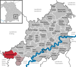 | ||
| Coordinates: 48°09′00″N 12°05′30″E / 48.15000°N 12.09167°ECoordinates: 48°09′00″N 12°05′30″E / 48.15000°N 12.09167°E | ||
| Country | Germany | |
| State | Bavaria | |
| Admin. region | Oberbayern | |
| District | Mühldorf am Inn | |
| Municipal assoc. | Maitenbeth | |
| Government | ||
| • Mayor | Josef Kirchmaier | |
| Area | ||
| • Total | 30.94 km2 (11.95 sq mi) | |
| Population (2015-12-31)[1] | ||
| • Total | 1,989 | |
| • Density | 64/km2 (170/sq mi) | |
| Time zone | CET/CEST (UTC+1/+2) | |
| Postal codes | 83558 | |
| Dialling codes | 08076 | |
| Vehicle registration | MÜ | |
| Website | www.maitenbeth.de | |

Maitenbeth is a municipality in the district of Mühldorf in Bavaria in Germany.
Maitenbeth consists of 58 official communes.:[2]
|
|
|
|
References
This article is issued from Wikipedia - version of the 5/17/2015. The text is available under the Creative Commons Attribution/Share Alike but additional terms may apply for the media files.