Main Township, Columbia County, Pennsylvania
| Main Township, Pennsylvania | |
|---|---|
| Township | |
|
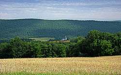
Nescopeck Mountain in Main Township | |
 Map of Columbia County, Pennsylvania highlighting Main Township | |
 Map of Columbia County, Pennsylvania | |
| Country | United States |
| State | Pennsylvania |
| County | Columbia |
| Settled | 1772 |
| Incorporated | 1844 |
| Area | |
| • Total | 16.6 sq mi (43.1 km2) |
| • Land | 16.1 sq mi (41.8 km2) |
| • Water | 0.5 sq mi (1.3 km2) |
| Population (2010) | |
| • Total | 1,236 |
| • Density | 77/sq mi (29.6/km2) |
| Time zone | Eastern (EST) (UTC-5) |
| • Summer (DST) | EDT (UTC-4) |
| Area code(s) | 570 |
| Website |
maintownship |
Main Township is a township in Columbia County, Pennsylvania, United States. The population was 1,236 at the 2010 census.[1] Main Township was settled in 1772 and incorporated in 1844. The iron industry was once prevalent in the township.
History
The area that is now Main Township was part of Augusta Township, then Catawissa Township until 1799, and part of Mifflin Township until January 1844. The Pennsylvania Railroad once passed through the township. In 1808, the Reading Road was created and passed through Main Township, allowing easier access to it. By this time, several settlers had arrived and settled in the township.[2]
Main Township was settled by settlers of European descent in 1772, at which time the township was part of Berks County.[2]
The main historical industry in Main Township was the iron industry. In 1815, a charcoal-iron furnace was built in the township.[2]
Geography

Main Township is located just south of the center of Columbia County and is bordered to the north by the Susquehanna River, lined by 500-foot-high (150 m) bluffs. The unincorporated community of Mainville is in the center of the township. The ridges of Nescopeck Mountain and Catawissa Mountain cross the township just south of Mainville, separated by a water gap formed by Catawissa Creek.
According to the United States Census Bureau, the township has a total area of 16.6 square miles (43.1 km2), of which 16.1 square miles (41.8 km2) is land and 0.50 square miles (1.3 km2), or 3.08%, is water.[1]

Demographics
As of the census[3] of 2010, there were 1,236 people, 513 households, and families residing in the township. The population density was 79.6 people per square mile (30.7/km2). There were 490 housing units at an average density of 30.2/sq mi (11.7/km2). The racial makeup of the township was 98.22% White, 1.01% African American, 0.31% Asian, 0.31% Pacific Islander, 0.08% from other races, and 0.08% from two or more races. Hispanic or Latino of any race were 0.78% of the population.
There were 469 households, out of which 38.0% had children under the age of 18 living with them, 67.0% were married couples living together, 8.3% had a female householder with no husband present, and 21.1% were non-families. 17.7% of all households were made up of individuals, and 6.6% had someone living alone who was 65 years of age or older. The average household size was 2.73 and the average family size was 3.09.
In the township the population was spread out, with 27.9% under the age of 18, 8.1% from 18 to 24, 26.7% from 25 to 44, 26.9% from 45 to 64, and 10.4% who were 65 years of age or older. The median age was 38 years. For every 100 females there were 101.7 males. For every 100 females age 18 and over, there were 95.8 males.
The median income for a household in the township was $41,339, and the median income for a family was $47,574. Males had a median income of $32,069 versus $21,250 for females. The per capita income for the township was $19,357. About 6.9% of families and 7.8% of the population were below the poverty line, including 6.1% of those under age 18 and 7.7% of those age 65 or over.
Education
Before Main Township was separated from Catawissa Township, children in Main Township went to a school in western Catawissa Township. In 1820, Jacob Gensel opened a school in a carding mill on Scotch Run. In 1824, another school was opened in the township, this time near a church. By 1886, there were five teachers in the township. By 1915, there were 114 students and six schools in Main Township.[2]
References
- 1 2 "Geographic Identifiers: 2010 Census Summary File 1 (G001): Main township, Columbia County, Pennsylvania". U.S. Census Bureau, American Factfinder. Retrieved May 21, 2015.
- 1 2 3 4 Historical and Biographical Annals of Columbia and Montour Counties, Pennsylvania, Containing a Concise History of the Two Counties and a Genealogical and Biographical Record of Representative Families ... J. H. Beers & Company. 1915. Retrieved 2014-11-15.
- ↑ "American FactFinder". United States Census Bureau. Retrieved 2008-01-31.
External links
Municipalities and communities of Columbia County, Pennsylvania, United States | ||
|---|---|---|
| Town | | |
| Boroughs | ||
| Townships | ||
| CDPs | ||
| Unincorporated communities | ||
| Ghost Towns | ||
| Footnotes | ‡This populated place also has portions in an adjacent county or counties | |
Coordinates: 41°01′00″N 76°21′59″W / 41.01667°N 76.36639°W