Main Street Historic District (Durham, Connecticut)
|
Main Street Historic District | |
|
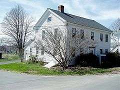
The Oliver Knowles House (1839) | |
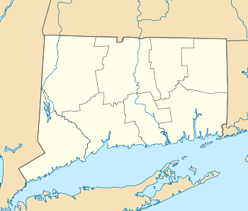  | |
| Location | Roughly Maple Ave. and Main St. between Talcott Ln. and Higganum Rd., Durham, Connecticut |
|---|---|
| Coordinates | 41°28′26″N 72°40′51″W / 41.47389°N 72.68083°WCoordinates: 41°28′26″N 72°40′51″W / 41.47389°N 72.68083°W |
| Area | 160 acres (65 ha) |
| Architectural style | Colonial Revival, Greek Revival, Colonial |
| NRHP Reference # | 86002837[1] |
| Added to NRHP | September 4, 1986 |
The Main Street Historic District in Durham, Connecticut is a historic district that was listed on the National Register of Historic Places in 1986.[1] The district is primarily linear and runs along Main Street (Route 17) from between Higganum Road and Town House Road in the south to Talcott Lane in the north. The district also includes properties on the parallel road known as Maple Avenue. It contains 112 contributing and 23 non-contributing properties over an area of 160 acres (65 ha). The area is also known as Durham Center and is where several state highways converge. The district encompasses the historic town center of Durham, and includes most of its colonial architecture, as well as many of its civic buildings.[2]
See also
References
- 1 2 National Park Service (2009-03-13). "National Register Information System". National Register of Historic Places. National Park Service.
- ↑ "NRHP nomination for Main Street Historic District" (PDF). National Park Service. Retrieved 2014-11-26.
| Topics | |
|---|---|
| Lists by states |
|
| Lists by insular areas | |
| Lists by associated states | |
| Other areas | |
| |
This article is issued from Wikipedia - version of the 11/28/2016. The text is available under the Creative Commons Attribution/Share Alike but additional terms may apply for the media files.