Mahlog


| Mahlog State माहिलोग | |||||
| Princely State | |||||
| |||||
| History | |||||
| • | Established | Late 16th century | |||
| • | Independence of India | 1948 | |||
| Area | |||||
| • | 1901 | 127 km2 (49 sq mi) | |||
| Population | |||||
| • | 1901 | 8,968 | |||
| Density | 70.6 /km2 (182.9 /sq mi) | ||||
| | |||||
Mehlog or Mailog was a princely state of India during the period of the British Raj. In 1940 it had a population of 8,631 and an area of 49 square miles (130 km2). The capital city was Patta.[1]
On 15 April 1948 Mahlog acceded to the Indian Union. Later it was merged into the Indian state of Himachal Pradesh.
History
The state of Mahlog was founded originally in 1183.Earlier its ruler were ruling near Kalka when Mohamad Gauri attacked and they shifted to Mahlog area.Initially 193 villages and forest land of the same habitationstae but at the end over 300 villages were included in it.It was the one of th biggest Princely State of Simla Hill States under British Raj.It was subject to Bilaspur State during the late 18th century. from 1803 to 1815 it was occupied by the Gurkhas of Nepal. After the occupation ended it became a British protectorate.[2]
Rulers
Mahlog State was ruled by Rajputs of the Suryavanshi dynasty. The rulers of the state bore the title 'Thakur'.[3]
Thakurs
-

Milestone of establishment of Palace and fort of Mahlog State, under Simla Hill States ,Himachal Pradesh,India
-

Roll of Rulers of Mahlog State, under Simla Hill States ,Himachal Pradesh,India
- .... - 1801 Nahar Chand (d. 1801)
- 1801 - 1803 Sansar Chand (1st time) (d. 1849)
- 1803 - 1815 occupied by Nepal
- 1815 - 1849 Sansar Chand (2nd time) (s.a.)
- 1849 - 1880 Dhalip Chand (b. 1829 - d. 1880)
- 16 May 1880 - 16 Sep 1902 Raghunath Chand (b. 1861/66 - d. 1902) (personal style Rana)
- 1902 - 16 Dec 1934 Durga Chand (b. 1898 - d. 1934)
- 16 Dec 1934 - 15 Aug 1947 Narindar Chand (b. 1921 - d. 2011)
- 16 Dec 1934 - 1942 .... -Regent
See also
Gallery
-
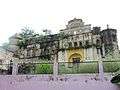
Palace and fort of Mahlog State, under Simla Hill States, Himachal Pradesh, India
-

Palace of Mahlog State under Simla Hill States Superintendency of the Punjab States Agency, Himachal Pradesh, India
-

Architecture style of Mahlog State, under Simla Hill States, Himachal Pradesh, India
-
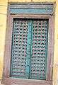
Wood work art style, entrance door of Mahlog palace, under Simla Hill States, Himachal Pradesh, India
-
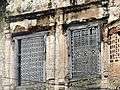
Wood work art style, windows of Mahlog palace, under Simla Hill States, Himachal Pradesh, India
-

Photo of Rana Narinder Chand at Aitchison College Lahor (1st in 2nd row), the last ruler of Mahlog State, under Simla Hill States, Himachal Pradesh, India. Other in pic:@Standing;sh.Harwant Raj,Sh.Mukhtiar Hussain,Sh.Rampartap S.,Sh. Zafar Khan,Sh.Daljinder Singh,Sh.Riffat.@Sitting;Sh.Rana Narinder Chand,S.Rai Singh,Sh.,Sh.Parminder Singh, Sh.Zulfikar Ali, Sh. Manzawar Ali.
References
- ↑ Columbia-Lippincott Gazeteer, p. 1122.
- ↑ Princely states of India
- ↑ Mahilog (Princely State)
Coordinates: 31°11′N 76°34′E / 31.183°N 76.567°E