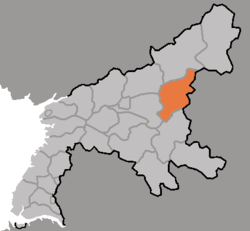
Maengsan County
| Maengsan County 맹산군 | |
|---|---|
| County | |
| Korean transcription(s) | |
| • Chosŏn'gŭl | 맹산군 |
| • Hancha | 孟山郡 |
| • McCune-Reischauer | Maengsan-gun |
| • Revised Romanization | Maengsan-gun |
 | |
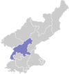
| Country | North Korea |
| Province | South P'yŏngan |
| Administrative divisions | 1 ŭp, 24 ri |
| Area | |
| • Total | 723.13 km2 (279.20 sq mi) |
| Population (2008[1]) | |
| • Total | 48,155 |
| • Density | 67/km2 (170/sq mi) |
Maengsan County is a kun (county) in South P'yŏngan, North Korea.
Administrative districts
The district is split into one ŭp (town) and 24 ri (villages):
|
|
References
- ↑ Korean Central Bureau of Statistics: 2008 Population Census (Population 2008, published in 2009)
External links
- (English) Map of Pyongan provinces
- (Korean) Detailed map
This article is issued from Wikipedia - version of the 12/22/2015. The text is available under the Creative Commons Attribution/Share Alike but additional terms may apply for the media files.