Madolenihmw
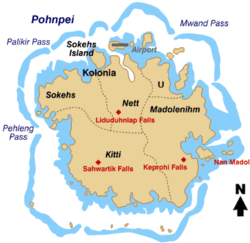
Map of Pohnpei Island showing the municipalities.
Madolenihmw is one of the administrative divisions of the Micronesian island of Pohnpei. It is located in the central east of the island, to the east of Mount Nahna Laud and south of Mount Kapwuriso. The coast of Madolenihmw includes a large bay which contains the island of Temwen, famous for its Nan Madol ruins.
Climate
See also
- Kitti (municipality)
- Sokehs
- U, Pohnpei
- Nett
- Kapingamarangi
- Pingelap
- Sapwuahfik
- Nukuoro
- Mokil
- Kolonia
- Oroluk
- Palikir
References
Bendure, G., & Friary, N. (1988) Micronesia: A travel survival kit. South Yarra, Australia: Lonely Planet.
Coordinates: 6°49′15″N 158°18′10″E / 6.82083°N 158.30278°E
This article is issued from Wikipedia - version of the 10/7/2014. The text is available under the Creative Commons Attribution/Share Alike but additional terms may apply for the media files.