Madison County, Idaho
| Madison County, Idaho | ||
|---|---|---|
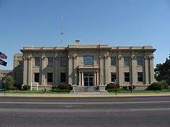 Madison County Courthouse | ||
| ||
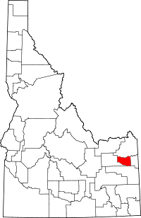 Location in the U.S. state of Idaho | ||
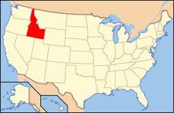 Idaho's location in the U.S. | ||
| Founded | February 18, 1913 | |
| Named for | James Madison | |
| Seat | Rexburg | |
| Largest city | Rexburg | |
| Area | ||
| • Total | 473 sq mi (1,225 km2) | |
| • Land | 469 sq mi (1,215 km2) | |
| • Water | 4.0 sq mi (10 km2), 0.8% | |
| Population (est.) | ||
| • (2015) | 38,273 | |
| • Density | 80/sq mi (31/km²) | |
| Congressional district | 2nd | |
| Time zone | Mountain: UTC-7/-6 | |
| Website |
www | |

Madison County is a county located in the U.S. state of Idaho. As of the 2010 census, the population was 37,536.[1] The county seat and largest city is Rexburg.[2]
Madison County is part of the Rexburg, ID Micropolitan Statistical Area, which is also included in the Idaho Falls-Rexburg-Blackfoot, ID Combined Statistical Area.
History
The area was originally settled by members of The Church of Jesus Christ of Latter-day Saints (Mormons). Before February 1913, the county was part of neighboring Fremont County. The newly established county was named for American president James Madison.[3] BYU-Idaho, formerly Ricks College (named after early local LDS settler Thomas Edwin Ricks) is located here. Madison County was declared a national disaster area after the Teton Dam flood of June 5, 1976.
Government and politics
Similar to other Idaho counties, an elected three-member county commission heads the county government. Other elected officials include clerk, treasurer, sheriff, assessor, coroner, and prosecutor.[4]
With a strongly conservative and Mormon population, Madison County is one of the most staunchly Republican counties in the United States. Since 1980 no Republican presidential candidate has failed to carry the county with less than 57 percent of the vote. In that same period Republican presidential candidates polled more than 90 percent of the county's vote on three occasions, Ronald Reagan in 1984,[5] George W. Bush in 2004,[6] and Mitt Romney in 2012.[7] John McCain came close to this level in 2008, drawing 85 percent of the vote.[8]
At the state level Madison County is located in Legislative District 34,[9] which currently has an all-Republican delegation in the Idaho Legislature.[10]
Geography
According to the U.S. Census Bureau, the county has a total area of 473 square miles (1,230 km2), of which 469 square miles (1,210 km2) is land and 4.0 square miles (10 km2) (0.8%) is water.[11] It is the third-smallest county in Idaho by area.
Adjacent counties
- Fremont County - north
- Teton County - east
- Bonneville County - south
- Jefferson County - west
Major highways
National protected area
- Targhee National Forest (part)
Demographics
| Historical population | |||
|---|---|---|---|
| Census | Pop. | %± | |
| 1920 | 9,167 | — | |
| 1930 | 8,316 | −9.3% | |
| 1940 | 9,186 | 10.5% | |
| 1950 | 9,156 | −0.3% | |
| 1960 | 9,417 | 2.9% | |
| 1970 | 13,452 | 42.8% | |
| 1980 | 19,480 | 44.8% | |
| 1990 | 23,674 | 21.5% | |
| 2000 | 27,467 | 16.0% | |
| 2010 | 37,536 | 36.7% | |
| Est. 2015 | 38,273 | [12] | 2.0% |
| U.S. Decennial Census[13] 1790-1960[14] 1900-1990[15] 1990-2000[16] 2010-2013[1] | |||
2000 census
As of the census[17] of 2000, there were 27,467 people, 7,129 households, and 4,854 families residing in the county. The population density was 58 people per square mile (22/km²). There were 7,630 housing units at an average density of 16 per square mile (6/km²). The racial makeup of the county was 95.50% White, 0.24% Black or African American, 0.33% Native American, 0.57% Asian, 0.18% Pacific Islander, 2.23% from other races, and 0.95% from two or more races. 3.92% of the population were Hispanic or Latino of any race. 30.6% were of English, 10.7% German, 10.2% American and 5.3% Danish ancestry according to Census 2000.
There were 7,129 households out of which 39.00% had children under the age of 18 living with them, 60.10% were married couples living together, 5.70% had a female householder with no husband present, and 31.90% were non-families. 12.70% of all households were made up of individuals and 5.60% had someone living alone who was 65 years of age or older. The average household size was 3.66 and the average family size was 3.70.
In the county the population was spread out with 26.20% under the age of 18, 39.90% from 18 to 24, 16.00% from 25 to 44, 11.90% from 45 to 64, and 6.00% who were 65 years of age or older. The median age was 21 years. For every 100 females there were 90.90 males. For every 100 females age 18 and over, there were 83.60 males.
The median income for a household in the county was $32,607, and the median income for a family was $40,880. Males had a median income of $29,299 versus $18,628 for females. The per capita income for the county was $10,956. About 10.10% of families and 30.50% of the population were below the poverty line, including 11.70% of those under age 18 and 10.10% of those age 65 or over.
2010 census
As of the 2010 United States Census, there were 37,536 people, 10,611 households, and 7,887 families residing in the county.[18] The population density was 80.0 inhabitants per square mile (30.9/km2). There were 11,280 housing units at an average density of 24.0 per square mile (9.3/km2).[19] The racial makeup of the county was 93.9% white, 0.9% Asian, 0.5% black or African American, 0.3% American Indian, 0.1% Pacific islander, 2.8% from other races, and 1.5% from two or more races. Those of Hispanic or Latino origin made up 5.9% of the population.[18] In terms of ancestry, 35.9% were English, 14.8% were German, 6.0% were Danish, 5.7% were American, and 5.4% were Irish.[20]
Of the 10,611 households, 38.8% had children under the age of 18 living with them, 67.6% were married couples living together, 4.8% had a female householder with no husband present, 25.7% were non-families, and 10.1% of all households were made up of individuals. The average household size was 3.44 and the average family size was 3.42. The median age was 22.6 years.[18]
The median income for a household in the county was $35,461 and the median income for a family was $41,117. Males had a median income of $38,398 versus $22,440 for females. The per capita income for the county was $13,735. About 21.4% of families and 32.2% of the population were below the poverty line, including 20.9% of those under age 18 and 10.1% of those age 65 or over.[21]
Communities
Cities
Unincorporated community
See also
References
- 1 2 "State & County QuickFacts". United States Census Bureau. Retrieved July 1, 2014.
- ↑ "Find a County". National Association of Counties. Retrieved 2011-06-07.
- ↑ Idaho.gov - Madison County - accessed 2009-05-31
- ↑ Welcome to Madison County, Idaho
- ↑ Dave Leip's Atlas of U.S. Presidential Elections
- ↑ Dave Leip's Atlas of U.S. Presidential Elections
- ↑ Dave Leip's Atlas of U.S. Presidential Elections
- ↑ Dave Leip's Atlas of U.S. Presidential Elections
- ↑ Idaho Legislative District Map
- ↑ Idaho Legislative Districts
- ↑ "US Gazetteer files: 2010, 2000, and 1990". United States Census Bureau. 2011-02-12. Retrieved 2011-04-23.
- ↑ "County Totals Dataset: Population, Population Change and Estimated Components of Population Change: April 1, 2010 to July 1, 2015". Retrieved July 2, 2016.
- ↑ "U.S. Decennial Census". United States Census Bureau. Retrieved July 1, 2014.
- ↑ "Historical Census Browser". University of Virginia Library. Retrieved July 1, 2014.
- ↑ "Population of Counties by Decennial Census: 1900 to 1990". United States Census Bureau. Retrieved July 1, 2014.
- ↑ "Census 2000 PHC-T-4. Ranking Tables for Counties: 1990 and 2000" (PDF). United States Census Bureau. Retrieved July 1, 2014.
- ↑ "American FactFinder". United States Census Bureau. Retrieved 2008-01-31.
- 1 2 3 "DP-1 Profile of General Population and Housing Characteristics: 2010 Demographic Profile Data". United States Census Bureau. Retrieved 2016-01-09.
- ↑ "Population, Housing Units, Area, and Density: 2010 - County". United States Census Bureau. Retrieved 2016-01-09.
- ↑ "DP02 SELECTED SOCIAL CHARACTERISTICS IN THE UNITED STATES – 2006-2010 American Community Survey 5-Year Estimates". United States Census Bureau. Retrieved 2016-01-09.
- ↑ "DP03 SELECTED ECONOMIC CHARACTERISTICS – 2006-2010 American Community Survey 5-Year Estimates". United States Census Bureau. Retrieved 2016-01-09.
External links
 |
Fremont County | | ||
| Jefferson County | |
Teton County | ||
| ||||
| | ||||
| Bonneville County |
Municipalities and communities of Madison County, Idaho, United States | ||
|---|---|---|
| Cities | ||
Coordinates: 43°47′N 111°40′W / 43.79°N 111.66°W