Macomb Township, Michigan
| Macomb Township, Michigan | |
|---|---|
| Township | |
| Township of Macomb | |
 Macomb Township, Michigan Location within the state of Michigan | |
| Coordinates: 42°39′33″N 82°55′51″W / 42.65917°N 82.93083°WCoordinates: 42°39′33″N 82°55′51″W / 42.65917°N 82.93083°W | |
| Country | United States |
| State | Michigan |
| County | Macomb |
| Government | |
| • Supervisor | Janet Dunn |
| Area | |
| • Total | 36.3 sq mi (94.0 km2) |
| • Land | 36.3 sq mi (93.9 km2) |
| • Water | 0.04 sq mi (0.1 km2) 0.06% |
| Elevation | 604 ft (184 m) |
| Population (2014) | |
| • Total | 85,459 |
| • Density | 2,354.2/sq mi (909.0/km2) |
| Time zone | Eastern (EST) (UTC-5) |
| • Summer (DST) | EDT (UTC-4) |
| ZIP codes | 48042, 48044 |
| Area code(s) | 586 |
| FIPS code | 26-50480[1] |
| GNIS feature ID | 1626660[2] |
| Website |
www |
Macomb Township is a general law township and northern suburb of Detroit located in Macomb County in the U.S. state of Michigan, in the Metropolitan Detroit region. The township's population was 50,477 at the 2000 census. The 2010 Census places the township's population at 79,580, making it Michigan's fastest growing major municipality.
Communities
There are no incorporated villages within the township, but there are three unincorporated communities:
- Macomb or Macomb Corners is located in the northwest part of the township at 42°42′03″N 82°57′33″W / 42.70083°N 82.95917°W on Romeo Plank Road at 25 Mile Road, near the Middle Branch of the Clinton River.[3]
- Waldenburg is located in the central portion of the township at 42°39′26″N 82°56′15″W / 42.65722°N 82.93750°W, a few miles south of Macomb on Romeo Plank Road and the Clinton River,[4] chiefly in the 22 Mile Road area.
- Meade is located in the northeast portion of the township at 42°43′03″N 82°52′26″W / 42.71750°N 82.87389°W on the boundary with Ray Township[5] at 26 Mile Road and North Avenue.
History
The early founders of Macomb Township arrived in the early 19th century in search of flat and fertile farmland, like that near the Clinton River. Many of these early settlers were of German descent, and the German influences remain today. The Township of Macomb was officially approved by the Legislative Council on March 7, 1834.
The township was named in honor of General Alexander Macomb, who was a highly decorated veteran of the War of 1812; his successful mercantile family owned most of Macomb County at one time.
Macomb Township was also a large part of the lumber and logging industry of Southeast Michigan in the late 19th century and early 20th century. Logs would be transported south from Wolcott Mill in Ray Township, down the Middle Branch Clinton River to sawmills. This route became known as Romeo Plank, and is the name of the modern-day road that runs down the same route.
Growth
Macomb Township experienced significant growth during the period of 2000-2008, boasting a 48% increase in population.[6]
Geography
According to the United States Census Bureau, the township has a total area of 36.3 square miles (94 km2), of which 36.3 square miles (94 km2) is land and 0.04 square miles (0.10 km2) (0.06%) is water. The area is predominantly a mix of flat fertile land and swampy wetland, but beginning with the housing boom in the late 1990s, the area has been largely suburbanizing.
Neighboring communities:
 |
Washington Township | Ray Township | Lenox Township | |
| Shelby Township | |
Chesterfield Township | ||
| ||||
| | ||||
| Sterling Heights | Clinton Township | Harrison Township |
Demographics
As of the census[7] of 2010, there were 79,580 people and 27,585 households in the township. The population density was 2,196.8 per square mile (848.2/km²). There were 27,585 housing units. The racial makeup of the township was 90.5% White, 3.9% African American, 0.2% Native American, 3.1% Asian, 0.0% Pacific Islander, 0.7% from other races, and 1.6% from two or more races. Hispanic or Latino of any race were 2.3% of the population.
As of the census[1] of 2000, there were 50,478 people, 16,946 households, and 14,065 families residing in the township. The population density was 1,391.7 per square mile (537.3/km²). There were 17,922 housing units at an average density of 494.1 per square mile (190.8/km²). The racial makeup of the township was 96.12% White, 0.84% African American, 0.19% Native American, 1.41% Asian, 0.01% Pacific Islander, 0.31% from other races, and 1.12% from two or more races. Hispanic or Latino of any race were 1.46% of the population.
There were 16,946 households out of which 45.3% had children under the age of 18 living with them, 73.7% were married couples living together, 6.5% had a female householder with no husband present, and 17.0% were non-families. 13.7% of all households were made up of individuals and 3.9% had someone living alone who was 65 years of age or older. The average household size was 2.97 and the average family size was 3.30.
In the township the population was spread out with 30.2% under the age of 18, 6.9% from 18 to 24, 35.1% from 25 to 44, 20.3% from 45 to 64, and 7.4% who were 65 years of age or older. The median age was 34 years. For every 100 females there were 99.6 males. For every 100 females age 18 and over, there were 97.3 males.
According to a 2006 estimate, the median income for a household in the township was $84,901, and the median income for a family was $88,458.
Notable people
- Danny DeKeyser - hockey player for Detroit Red Wings; born in Macomb.
- Eminem - rapper and recording artist, currently resides in Macomb Township.
- Mario Impemba - sportscaster, TV voice of Detroit Tigers and Oakland Golden Grizzlies men's basketball; lives in Macomb Township.
- Bob Learn, Jr. - professional ten-pin bowler and five-time champion on PBA Tour; born in Erie, Pennsylvania and now lives in Macomb Township.
- Masiela Lusha - Albanian-American actress and writer, lived here in her youth; born in Tirana, Albania.
- Michael McCarron - hockey player drafted in the first round of the 2013 NHL Entry Draft by the Montreal Canadiens; born in Macomb, Michigan.
Government
The public school districts that serve residents of Macomb Township are Chippewa Valley Schools, L'Anse Creuse Public Schools, New Haven Community Schools and Utica Community Schools.[8] For public library services, the Township is served by the Clinton-Macomb Public Library district.[9]
Media
The regional newspapers serving all of southeastern Michigan include the Detroit News and Detroit Free Press.
References
- 1 2 "American FactFinder". United States Census Bureau. Retrieved 2008-01-31.
- ↑ U.S. Geological Survey Geographic Names Information System: Macomb Township, Michigan
- ↑ U.S. Geological Survey Geographic Names Information System: Macomb, Michigan
- ↑ U.S. Geological Survey Geographic Names Information System: Waldenburg
- ↑ U.S. Geological Survey Geographic Names Information System: Meade, Michigan
- ↑ "Population and Households in Southeast Michigan, 2000-2008" (PDF). Retrieved 2012-06-30.
- ↑ http://www.census.gov/quickfacts/table/VET605214/2609950480/embed
- ↑ "Macomb County School District Map" (PDF). Michigan School District/County Series. Michigan Department of Information Technology. March 2008. Retrieved 7 February 2012.
- ↑ "Navigate Your Neighborhood Libraries" (PDF). Suburban Library Cooperative. p. 7. Retrieved 7 February 2012.
External links
- Clinton-Macomb Public Library Website
- Official Site Macomb Township
- Office Site Macomb Township Parks and Recreation
Municipalities and communities of Macomb County, Michigan, United States | ||
|---|---|---|
| Cities | 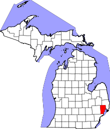 | |
| Villages | ||
| Charter townships | ||
| General law townships | ||
| Unincorporated community |
| |
| Footnotes | ‡This populated place also has portions in an adjacent county or counties | |
| Topics |  | |
|---|---|---|
| Detroit | ||
| Municipalities over 80,000 | ||
| Municipalities 40,000 to 80,000 | ||
| Cultural enclaves | ||
| Satellite cities | ||
| Counties in MSA | ||
| Counties in CSA | ||