M11 highway (Belarus)
| |
|---|---|
| Магістраль М11 | |
 | |
| Route information | |
|
Part of | |
| Length: | 191 km (119 mi) |
| Major junctions | |
| North end: | Border of Lithuania |
| South end: | Intersection with P2 |
| Location | |
| Major cities: | Lida, Slonim |
| Highway system | |
| Roads in Belarus | |

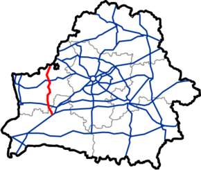
М11 highway is a part of European Route ![]() . Being 191 km long, it stretches through Hrodna Voblast and part of Brest Voblast in Belarus. The road begins at the Benyakoni border crossing (it is a continuation of Lithuanian
. Being 191 km long, it stretches through Hrodna Voblast and part of Brest Voblast in Belarus. The road begins at the Benyakoni border crossing (it is a continuation of Lithuanian ![]() highway) and goes south, passing Voranava, Lida, Dyatlovo and Slonim. It ends at the intersection with
highway) and goes south, passing Voranava, Lida, Dyatlovo and Slonim. It ends at the intersection with ![]() near village of Byten.
near village of Byten.
| Distance (approx.) |
Name | Other roads | |
|---|---|---|---|
| |
| ||
| 0 km | |
Benyakoni border crossing | |
| 11 km | |
Voranava | |
| 18 km | |
Voranava | |
| 24 km | |
Р135 | |
| 40 km | |
Lida | |
| 49 km | |
Lida | P89 |
| 56 km | |
Lida | |
| 59 km | |
| |
| 67 km | |
| |
| 81 km | |
P141 | |
| 104 km | |
Dyatlovo | |
| 116 km | |
P142 | |
| 125 km | |
Kazlowshchyna | |
| 152 km | |
Slonim | P41 P85 P99 |
| 158 km | |
Slonim | P99 |
| 191 km | |
| |
| National highways | ||
|---|---|---|
| European routes | ||
This article is issued from Wikipedia - version of the 10/12/2016. The text is available under the Creative Commons Attribution/Share Alike but additional terms may apply for the media files.