Münstertal, Black Forest
| Münstertal | ||
|---|---|---|
|
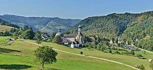
Saint Trudpert Monastery | ||
| ||
 Münstertal | ||
Location of Münstertal within Breisgau-Hochschwarzwald district 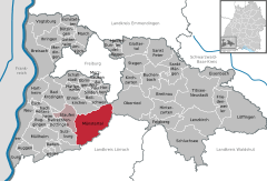
 | ||
| Coordinates: 47°51′17″N 7°47′3″E / 47.85472°N 7.78417°ECoordinates: 47°51′17″N 7°47′3″E / 47.85472°N 7.78417°E | ||
| Country | Germany | |
| State | Baden-Württemberg | |
| Admin. region | Freiburg | |
| District | Breisgau-Hochschwarzwald | |
| Government | ||
| • Mayor | Rüdiger Ahlers | |
| Area | ||
| • Total | 67.73 km2 (26.15 sq mi) | |
| Population (2015-12-31)[1] | ||
| • Total | 5,045 | |
| • Density | 74/km2 (190/sq mi) | |
| Time zone | CET/CEST (UTC+1/+2) | |
| Postal codes | 79242–79244 | |
| Dialling codes | 07636 | |
| Vehicle registration | FR | |
| Website | www.muenstertal.de | |

Münstertal is a municipality in the southern Black Forest, which belongs to the district of Breisgau-Hochschwarzwald in Baden-Württemberg in southern Germany. It is 3 miles east from Staufen.
Places
Museums
- Schwarzwaldhaus (Black Forest house), where the documentary film Schwarzwaldhaus 1902 was shot, is a museum about filming and the life of mountain farmers.
- Bienenkundemuseum (Museum for the study of bees).
- Teufelsgrund (Devil's Ground) was a silver mine and is today a museum about mining, but there is also an adit used for the treatment of asthma.
Buildings
- St. Trudpert was a benedictine monastery.
- Scharfenstein (Sharpstone) was a castle whose ruins can be visited in Obermünstertal.
References
This article is issued from Wikipedia - version of the 9/27/2016. The text is available under the Creative Commons Attribution/Share Alike but additional terms may apply for the media files.