Mödlareuth
| Mödlareuth | |
|---|---|
| Ortsteil of Töpen and Gefell | |
|
The Mödlareuth wall today is part of an open-air museum | |
| Nickname(s): Little Berlin | |
 | |
| Coordinates: 50°24′54.16″N 11°52′59.06″E / 50.4150444°N 11.8830722°ECoordinates: 50°24′54.16″N 11°52′59.06″E / 50.4150444°N 11.8830722°E | |
| Country |
|
| States |
Bavaria Thuringia |
| Regierungsbezirke |
Upper Franconia none |
| Districts |
Hof Saale-Orla-Kreis |
| Municipalities |
Töpen Gefell |
| Elevation | 543 m (1,781 ft) |
| Time zone | CET/CEST (UTC+1/+2) |
| Postal code |
95183 07926 |
| Dialing code |
(+49) 09295 (+49) 036649 |
| Vehicle registration |
HO SOK |
| Website | Official website |

Mödlareuth (German pronunciation: [ˈmøːdlaˌʁɔʏ̯t]) is a German village situated partly in Bavaria and partly in Thuringia. Between 1949 and 1990, the northern part was in East Germany and the southern part in West Germany. The Thuringian part of the village belongs to Gefell while the Bavarian part belongs to Töpen. It was called Little Berlin by the Americans[1] because a wall divided it until 1989, like the Berlin Wall divided Berlin. Little Berlin has become a symbol of separation between the West and East by the wall. Yet it is also a symbol of reunification. Therewith it also represents something greater which does not only concern Berlin or Mödlareuth, but the whole of Germany and all Germans. This applies to the past as well as the present.[2] Now the Museum Mödlareuth shows the history of the village and gives information about the political system at that time.
History
Early history
In the year 1374 the village is mentioned for the first time in a document of the parish church of Gefell (original spelling: Modelotenreut). Mödlareuth shows up in an urbarium of 1502 that registers the fief ownership in the region. However, no further information is available, not even the detailed location is documented. In 1810 (see Napoleonic Wars) the Tannbach stream (only around 30 cm wide), which flows through Mödlareuth, became the new border between the Kingdom of Bavaria and the principality of Reuss Junior Line. For 140 years this border made little difference to the local populace. There was just one school and one restaurant, both on the Reuss side, the villagers went to church in the neighboring Bavarian municipality Töpen.[3]
Cold War
In 1945, Thuringia (to which Reuß had belonged since 1920) became part of the Soviet occupation zone, while Bavaria went to the American occupation zone. When the constitutions of West Germany and East Germany were ratified in 1949, the village became divided by the border between two states. A pass was required to cross between the two parts of town.
In 1952, East Germany began to strengthen its western border. Residents of areas close to the border were forced to relocate, including some residents of Mödlareuth. In the case of Mödlareuth a wooden fence almost two metres high was built followed by more complex border fences. After the Berlin Wall was built in 1961, walls were built in other towns on the border as well. The wall separating the two halves of Mödlareuth was built in 1966. From that point on, the East German part of the village was strictly monitored day and night, while on the West German side the wall became a kind of tourist attraction. The Americans nicknamed the town Little Berlin.
In 1983, the then U.S. Vice President George H. W. Bush visited and exclaimed, "Ich bin ein Mödlareuther!", an allusion to John F. Kennedy's "Ich bin ein Berliner" statement.[1] Bush visited Mödlareuth together with the then Defense Minister of West-Germany Manfred Wörner who later became the seventh Secretary General of NATO.
In December 1989 a pedestrian crossing was opened at Mödlareuth. On 17 June 1990, seven months after the Berlin Wall fell and four months before German reunification, the Mödlareuth Wall was knocked down using a bulldozer. A portion has been retained as a memorial and is part of the museum in the village.
Mödlareuth today
The Thuringian part of the village of Mödlareuth belongs to the town of Gefell, and the Bavarian part to the community of Töpen.
Since 1994, Mödlareuth has had an open-air museum about the border between East and West Germany. It includes a portion of the original wall as well as a rebuilt barrier typical of those on the border at the time.
Although there is free passage between the two parts of the village today, there are still many differences. They have different postal codes and telephone area codes; the residents vote separately and send their children to different schools.
Gallery
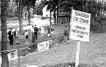 The Mödlareuth border in 1949
 The Mödlareuth border in 1989
 Open-air museum
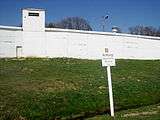 Mödlareuth Wall
See also
References
- 1 2 'Little Berlin' marks 40th anniversary of its own Cold War wall
- ↑ Springer Akademie, Little Berlin, What does "Little Berlin" mean?, 2009
- ↑ Springer Akademie, Von Modelotenreut zu Mödlareuth, 2009
External links
| Wikimedia Commons has media related to Mödlareuth. |
- (German) Mödlareuth official website
- (German) Mödlareuth Museum (Gefell municipal website)
- The DDR border at Mödlareuth on YouTube
- Photo Gallery by Enrico Martino