Lynmouth

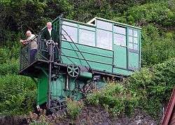

Lynmouth is a village in Devon, England, on the northern edge of Exmoor. The village straddles the confluence of the West Lyn and East Lyn rivers, in a gorge 700 feet (210 m) below Lynton, which was the only place to expand to once Lynmouth became as built-up as possible. Both villages are connected by the Lynton and Lynmouth Cliff Railway which works two cable-connected cars on gravity, using water tanks.
The two villages are a civil parish governed by Lynton and Lynmouth Town Council. The parish boundaries extend southwards from the coast and includes hamlets such as Barbrook and small moorland settlements such as East Ilkerton, West Ilkerton and Shallowford.
The South West Coast Path and Tarka Trail pass through, and the Two Moors Way runs from Ivybridge in South Devon to Lynmouth; the Samaritans Way South West runs from Bristol to Lynton and the Coleridge Way from Nether Stowey to Lynmouth.
Lynmouth was described by Thomas Gainsborough, who honeymooned there with his bride Margaret Burr, as "the most delightful place for a landscape painter this country can boast".
The Sillery Sands beach [lower-alpha 1] is just off the South West Coast Path and is used by naturists.[1]
Between June and August 1812, Percy Bysshe Shelley and his wife, Harriet, and his sister-in-law, Eliza, stayed in Lynmouth. Shelley worked on political pamphlets and on the poem "Queen Mab".
Lynmouth Lifeboat
A lifeboat station was established in Lynmouth on 20 January 1869, five months after the nearby wreck of the sailing vessel Home. The lifeboat was kept in a shed on the beach until a purpose-built boat house was built at the harbour. This was rebuilt in 1898 and enlarged in 1906–07. It was closed at the end of 1944 as other stations in the area could provide cover with their newer motor lifeboats. The boat house was then used as a club but was washed away in the flood of 15 August 1952. It has since been rebuilt and includes a public shelter.[2]
At 7:52 pm on 12 January 1899, a 1,900 ton three-masted ship Forrest Hall, carrying thirteen crew and five apprentices, was in trouble off Porlock Weir on the North Somerset coast to a severe gale which had been blowing all day. She had been under tow, but the tow rope had broken. She was dragging her anchor and had lost her steering gear. The ship's destruction was probable. The alarm was raised for the Louisa, the Lynmouth lifeboat, to be launched to assist. However, due to the terrible weather, the launch was impossible. Jack Crocombe, the coxswain of Louisa proposed to take the boat by road to Porlock's sheltered harbour – 13 miles (21 km) around the coast – and launch it from there.
The boat plus its carriage weighed about 10 tons, and transporting it would not be easy. 20 horses and 100 men started by hauling the boat up the 1 in 4 Countisbury Hill out of Lynmouth. Six of the men were sent ahead with picks and shovels to widen the road. The highest point is 1,423 feet (434 m) above sea level. After crossing the 15 miles (24 km) of wild Exmoor paths, the dangerous Porlock Hill had to be descended with horses and men pulling ropes to stall the descent; during this they had to demolish part of a garden wall and fell a large tree to make a way. The lifeboat reached Porlock Weir at 6:30 A.M. and was launched. Although cold, wet, hungry and exhausted, the crew rowed for over an hour in heavy seas to reach the stricken Forest Hall and rescue the thirteen men and five apprentices with no casualties; but four of the horses used died of exhaustion. The Forrest Hall was towed into Barry, Wales.
The event was immortalised in C Walter Hodges' 1969 children's historical novel, "The Overland Launch" and re-enacted 100 years later, in daylight, on today's much better roads.

1952 Lynmouth flood
On 15 and 16 August 1952, a storm of tropical intensity broke over South West England, depositing 229 millimetres (9.0 in) of rain within 24 hours on an already waterlogged Exmoor. It is thought that a cold front scooped up a thunderstorm, and the orographic effect worsened the storm. Debris-laden floodwaters cascaded down the northern escarpment of the moor, converging upon the village of Lynmouth; in particular, in the upper West Lyn valley, a dam was formed by fallen trees etc., which in due course gave way, sending a huge wave of water and debris down that river. The River Lyn through the town had been culverted to gain land for business premises; this culvert soon choked with flood debris, and the river flowed through the town. Much of the debris was boulders and trees.
Overnight, over 100 buildings were destroyed or seriously damaged along with 28 of the 31 bridges, and 38 cars were washed out to sea. In total, 34 people died, with a further 420 made homeless.
Similar events had been recorded at Lynmouth in 1607 and 1796. After the 1952 disaster, the village was rebuilt, including diverting the river around the village.
A conspiracy theory has circulated that the 1952 flood was caused by secret cloud seeding experiments conducted by the RAF.[3][4][5] The theory has been dismissed as "preposterous" by experts.[6]
The small group of houses on the bank of the East Lyn River called Middleham between Lynmouth and Watersmeet was destroyed and never rebuilt. Today, there stands a memorial garden.
A memorial hall dedicated to the disaster is on the front toward the harbour; it contains photographs, newspaper reports and a scaled model of the village, showing how it looked before the flood. A further photo and information display is found in St John the Baptist parish church.
.jpg)
Twinning
The town of Lynton and Lynmouth is twinned with Bénouville in France.
Cultural references
The British technical modern rock band InMe make recurring references to the Lynton/Lynmouth area in their lyrical material. Lynton is name-checked in "In Loving Memory" on their third album Daydream Anonymous and Lynmouth is name checked in "Saccharine Arcadia" on Phoenix: The Very Best of InMe. Lead singer Dave McPherson also has a song entitled "Sunny Lynton" on his EP Crescent Summer Sessions and refers to Watersmeet on "Waltzing in a Supermarket" on "I Don't Do Requests".
The village of Hollow Bay in The Secret of Crickley Hall by James Herbert is based on Lynmouth in Exmoor National Park, Devon; Devil's Cleave is the East Lyn Valley and Watersmeet. The book brings together two stories, child evacuees during WW2 and the famous 1952 flood disaster that devastated Lynmouth.
See also
Notes
- ↑ Location of Sillery Sands Beach 51°13′57″N 3°48′24″W / 51.232511°N 3.806723°W
- ↑ Sugden, R (6 June 2016). "7 ways to be naked in Bristol this summer". Bristol Post. Retrieved 2016-07-20.
- ↑ Leach, Nicholas (2009). Devon's Lifeboat Heritage. Chacewater: Twelveheads Press. pp. 49–50. ISBN 978-0-906294-72-7.
- ↑ Hilary Bradt; Janice Booth (11 May 2010). Slow Devon and Exmoor. Bradt Travel Guides. p. 249. ISBN 978-1-84162-322-1.
- ↑ "Rain-making link to killer floods". BBC News. 30 August 2001. Retrieved 14 June 2008.
- ↑ Vidal, John (30 August 2001). "RAF rainmakers 'caused 1952 flood'". London: The Guardian. Retrieved 10 November 2009.
- ↑ The day they made it rain, Philip Eden, WeatherOnline
External links
| Wikimedia Commons has media related to Lynmouth. |
- Lynton and Lynmouth at DMOZ
- The Lynmouth Flood of 1952 – Exmoor National Park Authority account
- Possible connections with cloud seeding (BBC News, 30 August 2001)
- On this day 16 August 1952 (BBC News)
- Lynmouth Foreland Lighthouse
Coordinates: 51°13′46″N 3°49′46″W / 51.22944°N 3.82944°W