Lyme, Connecticut
| Lyme, Connecticut | ||
|---|---|---|
| Town | ||
| ||
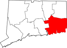
 Location within New London County, Connecticut | ||
| Coordinates: 41°24′N 72°21′W / 41.400°N 72.350°WCoordinates: 41°24′N 72°21′W / 41.400°N 72.350°W | ||
| Country | United States | |
| State | Connecticut | |
| NECTA | Norwich-New London | |
| Region | Connecticut River Estuary | |
| Settled | 1645 | |
| Incorporated | 1667 | |
| Government | ||
| • Type | Selectman-town meeting | |
| • First selectman | Ralph Eno (R) | |
| Area | ||
| • Total | 34.5 sq mi (89.4 km2) | |
| • Land | 31.9 sq mi (82.5 km2) | |
| • Water | 2.6 sq mi (6.8 km2) | |
| Elevation | 26 ft (8 m) | |
| Population (2010)[1] | ||
| • Total | 2,406 | |
| • Density | 70/sq mi (27/km2) | |
| Time zone | Eastern (UTC-5) | |
| • Summer (DST) | Eastern (UTC-4) | |
| ZIP code | 06371 (Old Lyme) | |
| Area code(s) | 860 | |
| FIPS code | 09-44210 | |
| GNIS feature ID | 0213453 | |
| Website |
townlyme | |

Lyme is a town in New London County, Connecticut, United States. The population was 2,406 at the 2010 census.[1] Lyme and its neighboring town Old Lyme are the namesake for Lyme disease.
Geography
According to the United States Census Bureau, the town has a total area of 34.5 square miles (89 km2), of which 31.9 square miles (83 km2) is land and 2.6 square miles (6.7 km2), or 7.63%, is water.
Principal communities
- Bill Hill
- Hadlyme
- Hamburg (town center)
- North Lyme
Other minor communities and geographic areas are Becket Hill, Brockway's Ferry (also known as Brockway Landing), Brush Hill, Elys Ferry, Grassy Hill, Gungy, Joshuatown, Lord Hill, Mt. Archer, Pleasant Valley, Rogers Lake West Shore, Sterling City, and Tuttles Sandy Beach.
History
The portion of the territory of the Saybrook Colony east of the Connecticut River was set off as the plantation of East Saybrook in February 1665. This area included present-day Lyme, Old Lyme, and the western part of East Lyme. In 1667, the Connecticut General Court formally recognized the East Saybrook plantation as the town of Lyme. The eastern portion of Lyme (bordering the town of Waterford) separated from Lyme and became East Lyme in 1823, and the southern portion of Lyme (along Long Island Sound) separated as South Lyme in 1855 (renamed to Old Lyme in 1857). These two changes were consistent with the then-existing laws in the state of Connecticut.
Demographics
| Historical population | |||
|---|---|---|---|
| Census | Pop. | %± | |
| 1820 | 4,069 | — | |
| 1850 | 2,668 | — | |
| 1860 | 1,246 | −53.3% | |
| 1870 | 1,181 | −5.2% | |
| 1880 | 1,025 | −13.2% | |
| 1890 | 977 | −4.7% | |
| 1900 | 750 | −23.2% | |
| 1910 | 746 | −0.5% | |
| 1920 | 674 | −9.7% | |
| 1930 | 546 | −19.0% | |
| 1940 | 717 | 31.3% | |
| 1950 | 857 | 19.5% | |
| 1960 | 1,183 | 38.0% | |
| 1970 | 1,484 | 25.4% | |
| 1980 | 1,822 | 22.8% | |
| 1990 | 1,949 | 7.0% | |
| 2000 | 2,016 | 3.4% | |
| 2010 | 2,406 | 19.3% | |
| Est. 2014 | 2,389 | [2] | −0.7% |
As of the 2010 census Lyme had a population of 2,406. The racial and ethnic makeup of the population was 96.5% non-Hispanic white, 0.1% non-Hispanic black, 0.1% non-Hispanic Native American, 1.0% Asian, 0.1% non-Hispanic from some other race, 0.6% from two or more races and 1.7% Hispanic or Latino.[4]
As of the census[5] of 2000, there were 2,016 people, 854 households, and 613 families residing in the town. The population density was 63.3 people per square mile (24.4/km²). There were 989 housing units at an average density of 31.0 per square mile (12.0/km²). The racial makeup of the town was 98.02% White, 0.05% African American, 0.05% Native American, 1.34% Asian, 0.05% from other races, and 0.50% from two or more races. Hispanic or Latino of any race were 1.14% of the population.
There were 854 households out of which 26.6% had children under the age of 18 living with them, 64.2% were married couples living together, 4.7% had a female householder with no husband present, and 28.2% were non-families. 23.2% of all households were made up of individuals and 10.7% had someone living alone who was 65 years of age or older. The average household size was 2.35 and the average family size was 2.76.
In the town the population was spread out with 20.3% under the age of 18, 3.1% from 18 to 24, 22.0% from 25 to 44, 34.7% from 45 to 64, and 19.9% who were 65 years of age or older. The median age was 47 years. For every 100 females there were 99.8 males. For every 100 females age 18 and over, there were 102.5 males.
The median income for a household in the town was $73,250, and the median income for a family was $82,853. Males had a median income of $56,188 versus $44,750 for females. The per capita income for the town was $43,347. None of the families and 1.2% of the population were living below the poverty line, including no under eighteens and none of those over 64.
| Voter registration and party enrollment as of October 25, 2005[6] | |||||
|---|---|---|---|---|---|
| Party | Active voters | Inactive voters | Total voters | Percentage | |
| Republican | 618 | 0 | 618 | 36.04% | |
| Democratic | 400 | 0 | 400 | 23.32% | |
| Unaffiliated | 694 | 0 | 694 | 40.47% | |
| Minor Parties | 3 | 0 | 3 | 0.17% | |
| Total | 1,715 | 0 | 1,715 | 100% | |
Transportation
The Estuary Transit District provides public transportation throughout Lyme and the surrounding towns through its 9 Town Transit Service. Services include connections to the Old Saybrook Train Station, served by Amtrak and Shore Line East railroads.
On the National Register of Historic Places
- Cooper Site (added November 15, 1987)
- Hadlyme Ferry Historic District (added December 21, 1994): 150, 151, 158, 159, 162-1, 162-2 Ferry Rd. and ferry slip
- Hadlyme North Historic District (added December 8, 1988): Roughly bounded by CT 82, Town St., Banning Rd., and Old Town St.
- Hamburg Bridge Historic District – Joshuatown Road and Old Hamburg Road (added April 10, 1983)
- Hamburg Cove Site (added November 15, 1987)
- Lord Cove Site (added November 15, 1987)
- Selden Island Site (added November 15, 1987)
- Seventh Sister (added July 31, 1986): 67 River Rd.
Notable people
Some of the earlier notables were residents of the portion of the town that later became Old Lyme.[7]
- Robert Ballard, oceanographer
- Joan Bennett (1910–1990), film and television actress, buried in town after her death in Scarsdale, New York
- Hiel Brockway (died 1842), founder of Brockport, New York
- Zebulon Brockway (1827–1920), a penologist some have called the "Father of prison reform" in the United States
- Daniel Chadwick (1825–1884), politician
- Donald Barr Chidsey (1902–1981), novelist and historian
- Wequash Cooke, Native American leader, buried in Lyme in 1642
- Dominick Dunne, author, had a house in Hadlyme for many years until his death
- Matthew Griswold (1714–1799), governor of the state (1784–1786)
- Roger Griswold (1762-1812), son of Mathew, US congressman (1785-1805), governor of the state (1811-1812), famous for brawl on the floor of Congress
- Roger Hilsman, World War II hero, post-war diplomat and author
- Harry Holtzman (1912–1987), abstract artist
- Ezra Lee (1749–1821), commander of the Turtle submarine during the Revolutionary War, and world's first submariner
- Beatrice Lillie, Canadian-born actress, had a house on Grassy Hill Road in the 1970s
- Abijah Perkins Marvin (1813-1889), minister, writer, and teacher; member of the Massachusetts Constitutional Convention of 1853, and of the New England Historic Genealogical Society
- Dudley Marvin, former US Congressman
- William Brown Meloney (1905–1971) and Rose Franken (1895-1988), husband-wife writing and play production team
- Robert Mulligan (1925–2008), film director, most notable work To Kill a Mockingbird
- Jonathan Parsons (1705–1776), prominent "New Light" clergyman who was influenced by Jonathan Edwards when Edwards taught at Yale
- Samuel Holden Parsons (1737–1789), active Patriot before and during the American Revolution and brigadier general in the Continental Army
- Jedediah Peck (1748–1821), called the "Father of the Common School System" of the state of New York
- Ansel Sterling (1782–1853), congressman from Connecticut, brother of Micah Sterling
- Micah Sterling (1784–1844), congressman from New York, brother of Ansel Sterling
- Allen Tucker (1838-1903), Medal of Honor recipient in the American Civil War
- Henry Matson Waite (1787-1869), Chief Justice of Connecticut Supreme Court, Father of Morrison Waite
- Morrison Remick Waite (1816–1888), Chief Justice of the United States (1874–1888)
References
- 1 2 "Profile of General Population and Housing Characteristics: 2010 Demographic Profile Data (DP-1): Lyme town, New London County, Connecticut". U.S. Census Bureau, American Factfinder. Retrieved October 25, 2012.
- ↑ "Annual Estimates of the Resident Population for Incorporated Places: April 1, 2010 to July 1, 2014". Retrieved June 4, 2015.
- ↑ "Census of Population and Housing". Census.gov. Retrieved June 4, 2015.
- ↑ 2010 census report on Lymn
- ↑ "American FactFinder". United States Census Bureau. Retrieved 2008-01-31.
- ↑ "Registration and Party Enrollment Statistics as of October 25, 2005" (PDF). Connecticut Secretary of State. Archived from the original (PDF) on 2006-09-23. Retrieved 2006-10-02.
- ↑ Burton, K. Old Lyme, Lyme, and Hadlyme. Arcadia Publishing,Charleston, SC, 2003 pp. 7–8.