Lyell Glacier
See also: Lyell Glacier, South Georgia
| Lyell Glacier | |
|---|---|
|
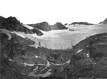
East lobe of Lyell Glacier | |
 Lyell Glacier  Lyell Glacier Location in California | |
| Type | Mountain glacier |
| Location | Yosemite National Park, Tuolumne County, California, United States |
| Coordinates | 37°44′35″N 119°16′09″W / 37.74306°N 119.26917°WCoordinates: 37°44′35″N 119°16′09″W / 37.74306°N 119.26917°W[1] |
| Length | .5 mi (0.80 km) estimated |
| Terminus | Talus |
| Status | Retreating |

Lyell Glacier is in the Sierra Nevada of California. The glacier was discovered by John Muir in 1871,[2] and was the largest glacier in Yosemite National Park. It lies on the northern slopes of Mount Lyell.[3]
The glacier has retreated since the end of the Little Ice Age in the mid-19th century. During the mid-20th Century, the glacier split into two smaller glaciers occupying the high cirques of Mount Lyell. Since 1883, the glacier area has retreated up to 70 percent.[4] Another glacier, the Maclure Glacier on nearby Mount Maclure, has also retreated significantly.
According to a study in 2013, today the Lyell is no longer a glacier, having lost any movement and thus it should considered an ice field.[5]
Lyell Glacier in 1883
See also
References
- ↑ "Lyell Glacier". Geographic Names Information System. United States Geological Survey. Retrieved 2012-09-30.
- ↑ Muir, John, 1873. On Actual Glaciers in California. American Journal of Science and Arts, v:69-71
- ↑ Mount Lyell, CA (Map). TopoQwest (United States Geological Survey Maps). Retrieved 2012-09-30.
- ↑ "Twentieth Century Glacier Change in the Sierra Nevada, California". Hassan Basagic. May 14, 2005. Archived from the original on 2006-09-06. Retrieved 2007-01-11.
- ↑ http://ww2.kqed.org/science/2013/05/27/californias-vanishing-glaciers-a-defining-moment
This article is issued from Wikipedia - version of the 8/5/2016. The text is available under the Creative Commons Attribution/Share Alike but additional terms may apply for the media files.