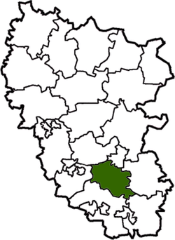
Lutuhyne Raion
| Lutuhynskyi Raion Лутугинський район | |||
|---|---|---|---|
| Raion | |||
| |||
 | |||
| Coordinates: 48°23′1″N 39°12′43″E / 48.38361°N 39.21194°ECoordinates: 48°23′1″N 39°12′43″E / 48.38361°N 39.21194°E | |||
| Country |
| ||
| Region | Luhansk Oblast | ||
| Established | 1965 | ||
| Admin. center | Lutuhyne | ||
| Subdivisions |
List
| ||
| Government | |||
| • Governor | Viktor Bordeev | ||
| Area | |||
| • Total | 1,057 km2 (408 sq mi) | ||
| Population (2013) | |||
| • Total |
| ||
| Time zone | EET (UTC+2) | ||
| • Summer (DST) | EEST (UTC+3) | ||
| Postal index | 92000—92044 | ||
| Area code | +380 6436 | ||
| Website | http://lu.loga.gov.ua | ||
Lutuhyne Raion (Ukrainian: Лутугинський район) is a raion (district) in Luhansk Oblast of Eastern Ukraine. The administrative center of the raion is the town of Lutuhyne. Population: 67,563 (2013 est.)[1].
Since 2014, the raion has been controlled by forces of the Luhansk People's Republic.[2]
References
- ↑ "Чисельність наявного населення України (Actual population of Ukraine)" (in Ukrainian). State Statistics Service of Ukraine. Retrieved 21 January 2015.
- ↑ "Численность населения по состоянию на 1 октября 2015 года по Луганской Народной Республике" (PDF) (in Russian). Luhansk People's Republic. Retrieved 21 December 2015.
| Raions | |||||||
|---|---|---|---|---|---|---|---|
| Cities |
| ||||||
| |||||||
This article is issued from Wikipedia - version of the 12/25/2015. The text is available under the Creative Commons Attribution/Share Alike but additional terms may apply for the media files.