Tenzing–Hillary Airport
| Tenzing–Hillary Airport तेन्जिङ हिलारी विमानस्थल | |||||||||||
|---|---|---|---|---|---|---|---|---|---|---|---|
 | |||||||||||
| IATA: LUA – ICAO: VNLK | |||||||||||
| Summary | |||||||||||
| Airport type | Public | ||||||||||
| Serves | Lukla, Nepal | ||||||||||
| Elevation AMSL | 9,334 ft / 2,845 m | ||||||||||
| Coordinates | 27°41′16″N 086°43′53″E / 27.68778°N 86.73139°ECoordinates: 27°41′16″N 086°43′53″E / 27.68778°N 86.73139°E | ||||||||||
| Map | |||||||||||
 LUA Location of airport in Nepal | |||||||||||
| Runways | |||||||||||
| |||||||||||
Tenzing–Hillary Airport (IATA: LUA, ICAO: VNLK), also known as Lukla Airport, is a small airport in the town of Lukla,[2] in Khumbu, Solukhumbu District, Province No. 1, eastern Nepal. A program titled Most Extreme Airports, broadcast on The History Channel in 2010, rated the airport as the most dangerous airport in the world for over 20 years.[3]
In January 2008 the airport was renamed in honor of Sherpa Tenzing Norgay and Sir Edmund Hillary, the first people to reach the summit of Mount Everest and also to mark their efforts in the construction of this airport.[4]
The airport is popular because Lukla is the place where most people start the climb to Mount Everest Base Camp. There are daily flights between Lukla and Kathmandu during daylight hours in good weather. Although the flying distance is short, rain commonly occurs in Lukla while the sun is shining brightly in Kathmandu. High winds, cloud cover, and changing visibility often mean flights can be delayed or the airport closed. The airport is contained within a chain link fence and patrolled by the Nepali armed police or civil police around the clock.[3]
Facilities

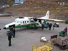
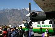
The airport's paved asphalt runway is accessible only to helicopters and small, fixed-wing, short-takeoff-and-landing aircraft such as the De Havilland Canada DHC-6 Twin Otter, Dornier Do 228, L-410 Turbolet and Pilatus PC-6 Turbo Porter. The runway is 527 m (1,729 ft) × 30 m (98 ft) with a 11.7% gradient.[1] The airport's elevation is 9,334 ft (2,845 m).[1] The airport is not only used for passenger flights, as most of the roofs on the houses at Lukla have to be transported by aircraft.
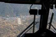
Aircraft can use runway 06 only for landings and runway 24 only for takeoffs. There is low prospect of a successful go-around on short final due to the terrain. There is high terrain immediately beyond the northern end of the runway and a steeply angled drop at the southern end of the runway into the valley below.
The apron has four stands and there is one helipad located 140 m (460 ft) from the control tower. No landing aids are available and the only air traffic service is an Aerodrome Flight Information Service.
Flight schedule
Lukla flights or flights to Tenzing–Hillary Airport normally occur between 6:30 am and 3:30 pm.
Airlines and destinations
| Airlines | Destinations |
|---|---|
| Gorkha Airlines | Kathmandu |
| Goma Air | Kathmandu |
| Nepal Airlines | Kathmandu, Phaplu, Rumjatar[5] |
| Simrik Airlines | Kathmandu[6] |
| Tara Air | Kathmandu[7] |
| Sita Air | Kathmandu |
Incidents and accidents
- On 15 October 1973, a Royal Nepal Airlines DHC-6 Twin Otter 300 (registration 9N-ABG) was damaged beyond repair on landing. The three crew and three passengers were unhurt.[8]
- On 9 June 1991, a Royal Nepal Airlines DHC-6 Twin Otter 300 (registration 9N-ABA) from Kathmandu crashed at the airport while attempting to land following an unstabilized approach in bad weather. The three crew and fourteen passengers escaped with injuries.[9]
- On 26 September 1992, a Royal Air Nepal Harbin Yunshuji Y-12-II (registered 9N-ACI) faltered during takeoff and was damaged beyond repair. All twelve passengers and two crew survived.[10]
- On 25 May 2004, while on approach to the airport, a Yeti Airlines DHC-6 Twin Otter Series 300 (registration 9N-AFD) from Kathmandu crashed into Lamjura Hill in heavy clouds. No passengers were on board; all three crew members were killed. The Nepalese accident investigation committee concluded that the captain provided inaccurate information about his position to the Area Control Centre.[11]
- On 1 October 2004, on landing at the airport, a Sita Air Dornier Do 228 suffered a collapse of its nose gear and slid along the runway, blocking it once it had come to rest. The airport was closed for two days.[12]
- On 30 June 2005, a Gorkha Airlines Dornier Do 228 skidded off the runway while attempting to land. The nine passengers and three crew suffered minor injuries. The aircraft was reportedly withdrawn from service and written off after the accident.[13][14]
- On 8 October 2008, Yeti Airlines Flight 103, a DHC-6 Twin Otter (registration 9N-AFE) crashed on final approach and caught fire, killing eighteen passengers and crew. The aircraft's captain was the only survivor. Video of the incident showed inclement weather at the time of the incident.[15]
- On 25 August 2010, Agni Air Flight 101, a Dornier Do 228, crashed at Shikharpur while returning to Kathmandu after bad weather had prevented it from reaching Lukla. All eleven passengers and three crew died.[16]
- On 12 October 2010, a Sita Air Dornier Do 228 (registration 9N-AHB) lost braking control and struck the wall-end of the runway during landing. All passengers and crew escaped injury; the aircraft's nose was damaged.[17]
- On 26 September 2013, an Air Dynasty helicopter (registration 9N-AEX) crashed when the rear rotor touched the barbed wire of the compound wall at the airport. All three passengers and the captain survived.[18]
Gallery
.jpg)
|


See also
References
- 1 2 3 "NATIONAL AIRPORTS PLAN Current Situation and Diagnostic" (PDF). Civil Aviation Authority of Nepal. Retrieved 7 March 2015.
- 1 2 Airport information for Lukla, Nepal – Tenzing–Hillary Airport (VNLK / LUA) at Great Circle Mapper.
- 1 2 "Most Extreme Airports". History Specials. Season 1. Episode 104. The History Channel. 26 August 2010.
- ↑ "Nepal to name Everest airport after Edmund Hillary and Tenzing Norgay". International Herald Tribune. 15 January 2008. Archived from the original on 12 February 2008. Retrieved 27 April 2010.
- ↑ "Nepal Airlines". Nepal Airlines. Retrieved 9 February 2012.
- ↑ .
- ↑ Scheduled Flights. Taraair.com. Retrieved 9 February 2012
- ↑ Aviation Safety Network. Retrieved 18 November 2006.
- ↑ "ASN Aircraft accident de Havilland Canada DHC-6 Twin Otter 300 9N-ABA Lukla Airport (LUA)". Retrieved 23 June 2011.
- ↑ "ASN Aircraft accident Harbin Yunshuji Y-12-II 9N-ACI Lukla Airport (LUA)". Aviation-safety.net. 26 September 1992. Retrieved 9 February 2012.
- ↑ Aviation Safety Network. Retrieved 18 November 2006.
- ↑ Aviation Safety Network. Retrieved 19 November 2006.
- ↑ Airline Industry Information, 30 June 2005.
- ↑ Aviation Safety Network. Retrieved 18 November 2006.
- ↑ BBC News. Retrieved 8 October 2008.
- ↑ Plane Crashes Near Everest. Retrieved 25 August 2010.
- ↑ Air Crash Observer . Retrieved 15 December 2010
- ↑ "Chopper crashes in Lukla, minor injuries". Nepalnews.com. 26 September 2013. Archived from the original on 3 March 2016.
External links
| Wikimedia Commons has media related to Lukla Airport. |
- Video of operations at the Lukla airport from YouTube
- Accident history for LUA / VNLK at Aviation Safety Network
- Photo of aircraft departing Lukla from Airliners.net
- "Most Dangerous airport in the world" Lukla Airport video
| International | |||||||
|---|---|---|---|---|---|---|---|
| Domestic |
| ||||||
| Defunct |
| ||||||
Unscheduled airports may be scheduled at certain times | |||||||