Lower Milford Township, Lehigh County, Pennsylvania
| Lower Milford Township | |
| Township | |
 | |
| Country | United States |
|---|---|
| State | Pennsylvania |
| County | Lehigh |
| Elevation | 650 ft (198.1 m) |
| Coordinates | 40°30′30″N 75°27′29″W / 40.50833°N 75.45806°WCoordinates: 40°30′30″N 75°27′29″W / 40.50833°N 75.45806°W |
| Area | 19.6 sq mi (50.8 km2) |
| - land | 19.6 sq mi (51 km2) |
| - water | 0.0 sq mi (0 km2), 0% |
| Population | 3,617 (2000) |
| Density | 184.1/sq mi (71.1/km2) |
| Timezone | EST (UTC-5) |
| - summer (DST) | EDT (UTC-4) |
| Area code | 610 and 215 |
 Location of Lower Milford Township in Lehigh County | |
 Location of Lower Milford Township in Pennsylvania | |
 Location of Pennsylvania in the United States | |
| Website: http://www.lowermilford.net | |
Lower Milford Township is a township in Lehigh County, Pennsylvania, in the United States. It is a suburb of Allentown, Pennsylvania, in the Lehigh Valley region of the state.
The population of Lower Milford Township was 3,775 at the 2010 census.
History
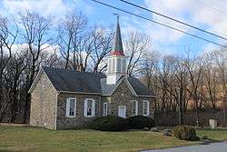
The Dillingersville Union School and Church was added to the National Register of Historic Places in 1978.[1]
Geography
According to the United States Census Bureau, the township has a total area of 19.6 square miles (50.9 km²), all of it land. Its villages include Corning (also in Upper Milford Township,) Dillingersville, Hosensack, Kraussdale, Limeport (also in Upper Saucon Township,) and Zionsville (also in Upper Milford Township.) While no numbered route has direct access to Lower Milford, its major roads are Churchview Road/Beverly Hills Road, Kings Highway, Limeport Pike, Palm Road, and Spinnerstown Road (which connects it with Route 663 and the Quakertown Interchange of Interstate 476 just over the Bucks County line.)
The township is located in the Delaware watershed. The Saucon Creek begins in Lower Milford and drains part of it into the Lehigh River. Lower Milford is also the source of three tributary creeks of the Perkiomen Creek, which drains to the Schuylkill River: Hosensack Creek (which starts near the source of the Saucon,) Unami Creek, and Macoby Creek. The majority of the township is mountainous and is located in the South Mountains and on Mill Hill to the south and east of the Hosensack Valley.
Adjacent municipalities
- Upper Milford Township (northwest)
- Upper Saucon Township (northeast)
- Springfield Township, Bucks County (tangent to the east)
- Milford Township, Bucks County (southeast)
- Upper Hanover Township, Montgomery County (southwest)
- Hereford Township, Berks County (tangent to the west)
Demographics
As of the census[2] of 2000, there were 3,617 people, 1,277 households, and 1,039 families residing in the township. The population density was 184.1 people per square mile (71.1/km²). There were 1,308 housing units at an average density of 66.6/sq mi (25.7/km²). The racial makeup of the township was 98.09% White, 0.17% African American, 0.25% Native American, 0.55% Asian, 0.11% from other races, and 0.83% from two or more races. Hispanic or Latino of any race were 0.69% of the population.
There were 1,277 households, out of which 35.5% had children under the age of 18 living with them, 71.6% were married couples living together, 6.0% had a female householder with no husband present, and 18.6% were non-families. 13.2% of all households were made up of individuals, and 4.7% had someone living alone who was 65 years of age or older. The average household size was 2.83 and the average family size was 3.12.
In the township the population was spread out, with 25.1% under the age of 18, 5.9% from 18 to 24, 29.2% from 25 to 44, 28.4% from 45 to 64, and 11.5% who were 65 years of age or older. The median age was 40 years. For every 100 females there were 102.2 males. For every 100 females age 18 and over, there were 101.2 males.
The median income for a household in the township was $67,008, and the median income for a family was $75,409. Males had a median income of $42,149 versus $26,000 for females. The per capita income for the township was $27,572. About 2.1% of families and 2.8% of the population were below the poverty line, including 1.3% of those under age 18 and 7.8% of those age 65 or over.
Education
Along with the borough of Coopersburg and Upper Saucon Township, Lower Milford is served by the Southern Lehigh School District. Three district schools serve the township's children: Lower Milford Elementary School, grades K-3; Southern Lehigh Intermediate School, Grades 4-6; Southern Lehigh Middle School, grades 7-8; and Southern Lehigh High School, grades 9-12.
Board of Supervisors
- Donna Wright, Chair, Republican
- Mike Snovitch, Vice-Chair, Republican
- John Quigley, Republican
References
- ↑ National Park Service (2009-03-13). "National Register Information System". National Register of Historic Places. National Park Service.
- ↑ "American FactFinder". United States Census Bureau. Retrieved 2008-01-31.
External links
| Wikimedia Commons has media related to Lower Milford Township, Lehigh County, Pennsylvania. |
Municipalities and communities of Lehigh County, Pennsylvania, United States | ||
|---|---|---|
| Cities | 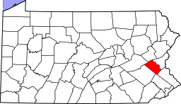 | |
| Boroughs | ||
| Townships | ||
| CDPs | ||
| Unincorporated communities |
| |
| Footnotes | ‡This populated place also has portions in an adjacent county or counties | |