Loulans-Verchamp
| Loulans-Verchamp | |
|---|---|
 Loulans-Verchamp | |
|
Location within Bourgogne-Franche-Comté region  Loulans-Verchamp | |
| Coordinates: 47°26′50″N 6°12′24″E / 47.4472°N 6.2067°ECoordinates: 47°26′50″N 6°12′24″E / 47.4472°N 6.2067°E | |
| Country | France |
| Region | Bourgogne-Franche-Comté |
| Department | Haute-Saône |
| Arrondissement | Vesoul |
| Canton | Montbozon |
| Area1 | 8.16 km2 (3.15 sq mi) |
| Population (2012)2 | 479 |
| • Density | 59/km2 (150/sq mi) |
| Time zone | CET (UTC+1) |
| • Summer (DST) | CEST (UTC+2) |
| INSEE/Postal code | 70309 / 70230 |
| Elevation | 232–297 m (761–974 ft) |
|
1 French Land Register data, which excludes lakes, ponds, glaciers > 1 km² (0.386 sq mi or 247 acres) and river estuaries. 2 Population without double counting: residents of multiple communes (e.g., students and military personnel) only counted once. | |
Loulans-Verchamp is a commune in the Haute-Saône department in the region of Bourgogne-Franche-Comté in eastern France.
Geographical Location
Loulans Verchamp is situated at a distance of:
- 12 km from Rioz via road D15
- 25 km from Vesoul via roads D15 and N57
- 30 km from Besançon via roads D25 or D15 and N57
- 120 km from Neuchatel in Switzerland via N57.
- 160 km from Lausanne in Switzerland via N57.
Loulans Verchamp is neighboured:
- On the north, by Roche-sur-Linotte-et-Sorans-les-Cordiers and Ormenans
- On the north-west by Villers-Pater
- On the west by Beaumotte-Aubertans
- On the south-west by Cenans
- On the south by Germondans of the Doubs region
- On the south-east by Flagey-Rigney of the Doubs region
- On the east by Maussans and Larians-et-Munans
- On the north-east by Montbozon
- The Linotte crosses the village of Loulans Verchamp, to join the river Ognon (Franche-Comté).
Roads and access
- The D15 and the D25 pass through Loulans Verchamp, connecting it to Vesoul on the north and to Besançon on the south.
- The high-speed railway line station Gare de Besançon-Auxon of the LGV Rhin-Rhône is situated at 30 km from Loulans Verchamp. It connects Besançon to Paris in just over two hours, with eight services a day (as of 2011).
- The Vesoul train station is 27 km away.
- The TGV - Gare de Besançon-Viotte train station is 32 km away.
- Neuchatel (Switzerland) is 120 km away.
- Lausanne (Switzerland) is 160 km away.
Demographics
| 1962 | 1968 | 1975 | 1982 | 1990 | 1999 | 2005 | 2012* |
|---|---|---|---|---|---|---|---|
| 428 | 448 | 400 | 406 | 354 | 378 | 445 | 479 |
| Number retained since 1962 : Population not accounting for double residences | |||||||
| * Annual survey (New mode of Census) | |||||||
Commerce
In the village there are two bar hotel restaurants, a bakery a hairdresser and a beauty salon.
Gallery
Some images from the village:
 rue des vignes, Loulans Verchamp
 Winter of 2010
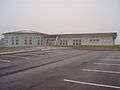 Elementary public school – December 2008
 The Memorial Monument – December 2008
 The road to Vesoul – D25
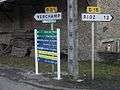 Intersection at Loulans Verchamp
Personalities linked to this commune
- Dominique Prétot (Papy) – president of the football club U.S. Larians – Munans, since 1967.
See also
References
- INSEE (English)
| Wikimedia Commons has media related to Loulans-Verchamp. |
This article is issued from Wikipedia - version of the 10/29/2016. The text is available under the Creative Commons Attribution/Share Alike but additional terms may apply for the media files.