Louisville, Alabama
| Louisville, Alabama | |
|---|---|
| Town | |
 | |
 Location in Barbour County and the state of Alabama | |
| Coordinates: 31°46′49″N 85°33′27″W / 31.78028°N 85.55750°WCoordinates: 31°46′49″N 85°33′27″W / 31.78028°N 85.55750°W | |
| Country | United States |
| State | Alabama |
| County | Barbour |
| Area | |
| • Total | 2.7 sq mi (7.1 km2) |
| • Land | 2.7 sq mi (7.1 km2) |
| • Water | 0 sq mi (0 km2) |
| Elevation | 551 ft (168 m) |
| Population (2010) | |
| • Total | 519 |
| • Density | 189/sq mi (72.9/km2) |
| Time zone | Central (CST) (UTC-6) |
| • Summer (DST) | CDT (UTC-5) |
| ZIP code | 36048 |
| Area code(s) | 334 |
| FIPS code | 01-44344 |
| GNIS feature ID | 0122049 |
Louisville is a town in Barbour County, Alabama, United States. At the 2010 census the population was 519.[1]
Geography
Louisville is 10 miles (16 km) southwest of Clayton, the county seat, and 6 miles (10 km) northeast of Clio.
According to the U.S. Census Bureau, the town has a total area of 2.8 square miles (7.1 km²), all land.[1]
Demographics
| Historical population | |||
|---|---|---|---|
| Census | Pop. | %± | |
| 1880 | 211 | — | |
| 1890 | 288 | 36.5% | |
| 1900 | 416 | 44.4% | |
| 1910 | 483 | 16.1% | |
| 1920 | 504 | 4.3% | |
| 1930 | 587 | 16.5% | |
| 1940 | 662 | 12.8% | |
| 1950 | 622 | −6.0% | |
| 1960 | 890 | 43.1% | |
| 1970 | 785 | −11.8% | |
| 1980 | 791 | 0.8% | |
| 1990 | 728 | −8.0% | |
| 2000 | 612 | −15.9% | |
| 2010 | 519 | −15.2% | |
| Est. 2015 | 487 | [2] | −6.2% |
| U.S. Decennial Census[3] 2013 Estimate[4] | |||
As of the census[5] of 2000, there were 612 people, 242 households, and 168 families residing in the town. The population density was 222.8 people per square mile (85.9/km²). There were 271 housing units at an average density of 98.6 per square mile (38.0/km²). The racial makeup of the town was 52.94% White, 40.69% Black or African American, 0.65% Native American, 5.23% from other races, and 0.49% from two or more races. 6.37% of the population were Hispanic or Latino of any race.
There were 242 households out of which 26.9% had children under the age of 18 living with them, 52.5% were married couples living together, 14.0% had a female householder with no husband present, and 30.2% were non-families. 26.9% of all households were made up of individuals and 16.5% had someone living alone who was 65 years of age or older. The average household size was 2.53 and the average family size was 3.05.
In the town the population was spread out with 23.7% under the age of 18, 10.6% from 18 to 24, 23.2% from 25 to 44, 22.1% from 45 to 64, and 20.4% who were 65 years of age or older. The median age was 39 years. For every 100 females there were 87.7 males. For every 100 females age 18 and over, there were 85.3 males.
The median income for a household in the town was $20,859, and the median income for a family was $27,014. Males had a median income of $27,500 versus $24,583 for females. The per capita income for the town was $13,151. About 22.4% of families and 28.0% of the population were below the poverty line, including 22.0% of those under age 18 and 34.8% of those age 65 or over.
Notable people
- George M. Grant, former U.S. Representative
- Jeremiah Norman Williams, U.S. Representative from Alabama's 2nd congressional district from 1875 to 1877
References
- 1 2 "Geographic Identifiers: 2010 Demographic Profile Data (G001): Louisville town, Alabama". U.S. Census Bureau, American Factfinder. Retrieved September 16, 2013.
- ↑ "Annual Estimates of the Resident Population for Incorporated Places: April 1, 2010 to July 1, 2015". Retrieved July 2, 2016.
- ↑ "U.S. Decennial Census". Census.gov. Retrieved June 6, 2013.
- ↑ "Annual Estimates of the Resident Population: April 1, 2010 to July 1, 2013". Retrieved June 3, 2014.
- ↑ "American FactFinder". United States Census Bureau. Retrieved 2008-01-31.
Gallery
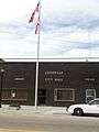 The Louisville City Hall, Police Department, and Public Library
 Louisville Fire Department
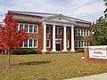 The Old Louisville School (established 1916)
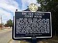 This historic marker denotes the former location of the Pike/Barbour County courthouse in Louisville.
Municipalities and communities of Barbour County, Alabama, United States | ||
|---|---|---|
| Cities |  | |
| Towns | ||
| Unincorporated communities | ||