Louisiana Highway 72
| ||||
|---|---|---|---|---|
 | ||||
| Route information | ||||
| Maintained by Louisiana DOTD | ||||
| Length: | 3.02 mi[1] (4.86 km) | |||
| Existed: | 1955 renumbering – present | |||
| Major junctions | ||||
| West end: |
| |||
|
| ||||
| East end: |
| |||
| Location | ||||
| Parishes: | Bossier | |||
| Highway system | ||||
| ||||
.svg.png)
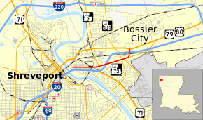
Louisiana Highway 72 (LA 72) is a state highway located in Bossier Parish, Louisiana. It runs 3.02 miles (4.86 km) in an east–west direction from Traffic Street, a local road, to the concurrent U.S. Highway 79 (US 79) and U.S. Highway 80 (US 80) in Bossier City.
The route serves as a commercial thoroughfare in Bossier City, running along Barksdale Boulevard through the old downtown area just east of the Red River. It then passes through a cluster of shopping centers as it continues onto Old Minden Road near the junction with LA 3. LA 72 parallels I-20 and provides access to the interstate at several different points along its short route.
Route description
From the west, LA 72 begins at an intersection with Traffic Street, a local road, directly opposite ramps leading to Exit 19B on westbound I-20 and northbound US 71, which travel concurrently across the Red River into Shreveport. Signs direct motorists southward on Traffic Street to reach eastbound I-10 and southbound US 71 at the same interchange. LA 72 proceeds east on Barksdale Boulevard and travels through Bossier City's traditional downtown area as an undivided, four-lane highway. At Mansfield Street, the roadway widens to accommodate a center turning lane.[2][3][4]
0.6 miles (0.97 km) later, Barksdale Boulevard curves to southeast, connecting with southbound US 71, while LA 72 continues straight ahead onto Old Minden Road. Shortly afterward, LA 72 intersects LA 3 (Benton Spur), which heads north through Benton and Plain Dealing. Directly opposite the southern terminus of LA 3 are ramps leading to US 71 and westbound I-20 at Exit 20B. A short distance later, LA 72 passes through a diamond interchange with I-20 at Exit 21. Continuing eastward, LA 72 intersects LA 3105 (Airline Drive), followed by LA 185 (Northgate Road), which leads to the nearby Barksdale Air Force Base.[2][3][4]
LA 72 then curves to the north and simultaneously intersects LA 782-2 (Industrial Drive). Shortly afterward, LA 72 crosses the Kansas City Southern Railway (KCS) tracks at grade and passes under, but does not intersect, I-20. LA 72 reaches its eastern terminus immediately afterward at an intersection with the concurrent US 79 and US 80 (East Texas Street).[2][3][4]
The route is classified as an urban minor arterial by the Louisiana Department of Transportation and Development (La DOTD).[1] Average daily traffic volume in 2013 is reported as follows: 7,900 from the western terminus to LA 3; 12,500 to I-20; and 12,300 to the eastern terminus.[1] The entire route has a posted speed limit of 35 mph (55 km/h).[2]
History
In the original Louisiana Highway system in use between 1921 and 1955, the modern LA 72 was originally designated as part of State Route 4, which followed the Dixie Overland Highway, an early auto trail, through northern Louisiana.[5][6] In 1926, it became part of the original route of US 80, which duplicated Route 4 east of Shreveport.[7] The Barksdale Boulevard segment also carried US 71, which shared a bridge across the Red River with US 80.[6] (Now demolished, the Traffic Street Bridge existed at the location of the current I-20 crossing.) When US 80 was re-routed through Bossier City onto Texas Street and the new Long-Allen Bridge in 1934, the former alignment became Route 4-D until the 1955 Louisiana Highway renumbering.[8][9]
La 72—From a junction with La 3 at or near Bossier City northeasterly to a junction with La-US 80.— 1955 legislative route description[10]
LA 72 was created with the 1955 renumbering, following only the portion of the current route east of LA 3.[10] When I-20 was opened through the area in 1966,[11] US 71 began to follow the parallel interstate alignment from Exit 20B–C westward across the Red River Bridge. LA 72 was then extended to follow the old route along Barksdale Boulevard west to Traffic Street and north onto Traffic Street to US 79/US 80.[12][13] (The Traffic Street segment had been used as a connector during various times when US 71 was routed over the Long-Allen Bridge; its original state route designation in the 1955 renumbering was LA 782-3.)[14][15] The Traffic Street connector was returned to local control in the 2000s, giving LA 72 its current western terminus.[3][16]
Future
La DOTD is currently engaged in a program that aims to transfer about 5,000 miles (8,000 km) of state-owned roadways to local governments over the next several years.[17] Under this plan of "right-sizing" the state highway system, the entire route of LA 72 is proposed for deletion as it does not meet a significant interurban travel function.[18]
Major intersections
The entire highway is in Bossier City, Bossier Parish.
| mi[2] | km | Destinations | Notes | ||
|---|---|---|---|---|---|
| 0.0 | 0.0 | Traffic Street to | Western terminus; Exit 19B on I-20/US 71 | ||
| 0.9 | 1.4 | Barksdale Boulevard to | |||
| 1.2 | 1.9 | Southern terminus of LA 3 | |||
| 1.5 | 2.4 | Exit 21 on I-20 | |||
| 2.3 | 3.7 | ||||
| 2.4 | 3.9 | Northern terminus of LA 185; to Barksdale Air Force Base | |||
| 2.6 | 4.2 | Western terminus of LA 782-2 | |||
| 3.0 | 4.8 | Eastern terminus | |||
| 1.000 mi = 1.609 km; 1.000 km = 0.621 mi | |||||
References
- 1 2 3 "La DOTD GIS". Louisiana Department of Transportation and Development. 2013. Retrieved July 25, 2013.
- 1 2 3 4 5 Google (July 19, 2013). "Overview Map of LA 72" (Map). Google Maps. Google. Retrieved July 19, 2013.
- 1 2 3 4 Bossier Parish (South Section) (PDF) (Map). Cartography by La DOTD Office of Multimodal Planning. Louisiana Department of Transportation and Development. February 2012. Retrieved July 19, 2013.
- 1 2 3 District 04: Official Control Section Map / Construction and Maintenance (PDF) (Map). Cartography by La DOTD Office of Multimodal Planning. Louisiana Department of Transportation and Development. February 2012. Retrieved July 19, 2013.
- ↑ "Act No. 95, House Bill No. 206". State-Times. Baton Rouge. November 29, 1921. p. 9.
- 1 2 Bossier Parish (Map). Cartography by Louisiana Highway Commission Map Department. Louisiana Highway Commission. 1930.
- ↑ Mileage Map of the Best Roads of Louisiana (Map). Cartography by Clason Map Company. Clason Map Company. 1927.
- ↑ Bossier Parish (Map). Cartography by State-Wide Highway Planning Survey. Louisiana Highway Commission. 1937.
- ↑ Bossier Parish (Map) (January 1, 1955 ed.). Cartography by Department of Highways Traffic and Planning Section. Louisiana Department of Highways. 1949.
- 1 2 "Act No. 40, House Bill No. 311". State-Times. Baton Rouge. June 18, 1955. p. 3B.
- ↑ "Interstate system in La. 37 pct. open". Times-Picayune. New Orleans. June 13, 1966. p. 3.
|section=ignored (help) - ↑ Louisiana (Map). Cartography by Louisiana Department of Highways. Louisiana Department of Highways. 1965.
- ↑ Louisiana (Map). Cartography by Louisiana Department of Highways. Louisiana Department of Highways. 1968.
- ↑ Louisiana (Map). Cartography by Louisiana Department of Highways. Louisiana Department of Highways. 1957.
- ↑ Bossier Parish (Map) (January 1, 1958 ed.). Cartography by Department of Highways Traffic and Planning Section. Louisiana Department of Highways. 1957.
- ↑ Bossier Parish (Map). Cartography by Office of Planning and Programming. Louisiana Department of Transportation and Development. 2000.
- ↑ "Right-Sizing the State Highway System" (PDF). Louisiana Department of Transportation and Development. April 2013. p. 3. Retrieved July 25, 2013.
- ↑ Right-Size the State Highway System: Bossier Parish (South Section) (PDF) (Map). Cartography by La DOTD Office of Multimodal Planning. Louisiana Department of Transportation and Development. December 2011. Retrieved July 25, 2013.