Lough Oughter
| Lough Oughter | |
|---|---|
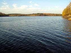 Lough Oughter in Killykeen | |
| Location | County Cavan |
| Coordinates | 54°01′01″N 7°23′18″W / 54.01694°N 7.38833°WCoordinates: 54°01′01″N 7°23′18″W / 54.01694°N 7.38833°W |
| Type | Eutrophic Glacial lake between drumlins. |
| Primary inflows | from various springs and streams |
| Primary outflows | River Erne Atlantic Ocean, Ballyshannon |
| Max. length | 12 km |
| Max. width | 10 km |
| Surface area | 8931 ha |
| Frozen | winter of 2010/2011 |
Lough Oughter (Irish: Loch Uachtair) is a lake, or complex of lakes, in County Cavan covering approximately 8931 hectares. It is on the River Erne, and forms the southern part of the Lough Erne complex. The lakes are bounded roughly by Belturbet in the north; Cavan Town to the east; Crossdoney to the south and Killeshandra to the west.
Scientific evaluations consider the Lough Oughter area as a whole as the best inland example of a flooded drumlin landscape in Ireland and has many rich and varied biological communities. Nowhere else in the country does such an intimate mixture of land and water occur over a comparable area, and many of the species of wetland plants, some considered quite commonplace in Lough Oughter and its associated loughs, are infrequent elsewhere. The number of whooper swans which winter in the area represents about 3% of the total European population while the lake also houses the largest concentration of breeding Great Crested Grebes in the Republic, having become almost extinct in the 19th century.
Lough Oughter has long been classed locally as an angling lake and is grossly under valued for its qualities as a potential venue for wildlife eco-tourism and education, is now designated as a suitable wetland for inclusion in the 'Ramsar List of Wetlands of International Importance'. Cavan County Council have stated: "It is recognized nationally and internationally as being of significant values not only for the country, but for humanity as a whole". It should also be noted that the Lough Oughter complex along with Killykeen Forest Park are designated Natura 2000 habitats, Special Areas for Conservation (SAC) and Special Protection Areas (SPA) under EU legislation. Lough Oughter is part of the UNESCO Marble Arch Caves Global Geopark.
The main threats to the quality of the site, according to scientific sources, are water polluting such as run-off from fertiliser and slurry applications and sewage discharge which have raised the nutrient status of some lakes to hypertrophic. Increased afforestation has resulted in some loss of wetland habitat and also loss of some feeding ground for wintering birds such as Greenland White-fronted Geese.
Recreation and eco-tourism

With their natural beauty and bio-diversity the Lough Oughter complex of lakes and wetlands make an ideal location for sustainable Ecotourism. The income can be significant and support livelihoods, locally and nationally. Wetlands provide other 'services', too, such as water, food, water purification, erosion control, etc., for the benefit of tourists and tourist accommodation. The income generated by tourism for national and local economies in and around wetlands can be substantial: the Broads in the UK supports the equivalent of 3,000 full-time jobs.
Killykeen Forest Park combines under the semi-government and Swiss bank controlled Coillte as a commercial forestry site which has long been recognised for its interesting history and all seasons recreational qualities, located just five miles from Cavan town and saddles on either side of the Lough Oughter system. Popular with angling visitors and favoured for its walking trails through the leafy glades and along the lake shores. What might be achieved instead with a fully worked out eco-tourism management plan.
Historic Settlement

Lough Oughter is synonymous with the ancient monastic settlement on Trinity Island that once sustained a substantial resident native population around its shores back to the earliest times of settlement with several identified island, crannog locations and megalithic wedge tomb structures. With the arrival of the Anglo Normans, the impressive Clogh Oughter Castle was built. It stands on a tiny island in Lough Oughter since the thirteenth century. It is circular in construction, some 15.5 metres in outside diameter and around 18 metres high. The nearest shore is approximately 130 metres away, close to the narrowest part of the lough at Inishconnell Rinn Point. Clogh Oughter Castle has been at the centre of much of County Cavan's turbulent History and was probably built originally to protect the clan O'Reilly chieftains from their warring neighbours. During the seventeenth century, the castle changed hands several times and was one of the last defended castles to hold out during the Confederate Wars. Before this, Clogh Oughter Castle was used as a prison. Notably, the Anglican Bishop of Kilmore, William Bedell was held hostage here, and rebel leader Owen Rua O'Neil is reputed to have died here in 1649 and was secretly brought to Trinity Island for burial. The rebel army were finally defeated in 1653, after which the lofty walls of Clogh Oughter castle were breached by cannon shot and have remained unoccupied ever since, apart from nesting crows and water fowl.
During the late nineteenth century water levels on Lough Oughter were lowered to alleviate flooding of low lying farmland. However, plans are now afoot through Waterways Ireland to raise the levels again to facilitate tourism and allow pleasure boats to gain access into the lough from the River Erne right up to Killeshandra.
See also
External links
- Ramsar International Convention on Wetlands website
- Bird Watch Ireland website
- National Parks and Wildlife Service
- Natura 2000 website
- Priority Woodland Restoration - The facts of LIFE
- Who Owns Coillte?
- Eutrophic Effects of Coniferous Forests on Biodiversity
- Killeshandra Loop Walk with downloadable map