Texas State Highway Loop 375
| ||||
|---|---|---|---|---|
| Route information | ||||
| Maintained by TxDOT | ||||
| Length: | 49.21 mi[1] (79.20 km) | |||
| Existed: | 1963 – present | |||
| Major junctions | ||||
| CCW end: |
| |||
| CW end: |
| |||
| Location | ||||
| Counties: | El Paso | |||
| Highway system | ||||
| ||||

Loop 375 partially encircles the city of El Paso, Texas. Locally, it is known as Woodrow Bean Transmountain Drive in the Northern section, Purple Heart Memorial Freeway in the Northeastern section, the César Chávez Border Highway in the southern section, and Joe Battle Boulevard in the eastern section.
The Texas Department of Transportation has announced plans to add toll lanes to the Border Highway portion of Loop 375 between Downtown El Paso and the Ysleta–Zaragoza International Bridge. TxDOT and the El Paso Metropolitan Planning Organization have offered several plans to build the Western leg of the loop from Downtown to Canutillo, Texas: Though not finalized, preliminary plans have included upgrading US 85/Paisano Drive to freeway status from Downtown to Sunland Park Drive, then allowing Loop 375 to run concurrently with Interstate 10 between Sunland Park Drive and Woodrow Bean Transmountain Road at Canutillo. In 2012, construction commenced of the freeway upgrade from Dyer Street east to I-10. This expansion has proved controversial, as the western leg of Transmountain Road passes through the protected Franklin Mountains State Park.[2]
- Clockwise, Loop 375 ends in downtown El Paso at US 62-85 Paisano Drive.
- Counterclockwise, Loop 375 ends near Canutillo at Interstate 10 and Spur 16.
Route description
Transmountain Road has many roadcuts which expose outcrops of Precambrian rocks, which are some of the oldest in Texas.[3] Units exposed include:
- Red Bluff Granite
- Castner Marble
- Mundy Breccia
- Lanoria Formation
- Thunderbird Group (large roadcut at Smuggler's Pass)
Gallery
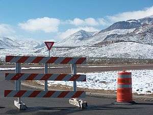 Snow in Franklin Mountains in El Paso causes closure of Woodrow Bean Transmountain Drive
 The largest road cut on Transmountain Road, at the 5280-foot crest of Smuggler's Pass
Exit list
The entire route is in El Paso County.
| Location | mi | km | Exit | Destinations | Notes | |
|---|---|---|---|---|---|---|
| El Paso | 0.00 | 0.00 | Interchange; counterclockwise terminus of Loop 375; I-10 exit 6A; road continues as Spur 16 | |||
| — | Northwestern Drive | Interchange; west (counterclockwise) end of freeway; eastbound exit and westbound entrance | ||||
| 11A | I-10 exit 6B | |||||
| 11B | Resler Drive | |||||
| 12 | Paseo Del Norte Drive | Interchange; east (clockwise) end of freeway | ||||
| Franklin Mountains State Park Tom Mays Unit | ||||||
| 21 | Interchange; west (counterclockwise) end of freeway; US 54 exit 29 | |||||
| 22 | ||||||
| 24 | Bomarc Street / Railroad Drive | Signed as Railroad Dr. only westbound | ||||
| Fort Bliss | — | Sergeant Major Blvd. Not a Public Exit – | Access to Biggs Army Airfield and East Fort Bliss | |||
| 30 | ||||||
| 32 | Iron Medics Drive | Will provide access to (under construction) William Beaumont Army Medical Center | ||||
| El Paso | 35 | |||||
| 38 | Edgemere Boulevard | |||||
| 39 | Pebble Hills Boulevard | |||||
| 40 | Signed as exit 40B northbound | |||||
| 40A | Northbound exit and southbound entrance | |||||
| 41 | Vista Del Sol Drive | |||||
| 42A | Pellicano Drive / Rojas Drive | Signed as exit 42 southbound; signed as Pellicano Dr. only northbound | ||||
| 42B | Bob Hope Drive | No direct southbound exit (signed at exit 42) | ||||
| 44 | No direct exits to I-10 east (signed southbound at exit 42 and northbound at exit 45); exits from frontage road signed as 44B (I-10 west) and 44C (I-10 east); I-10 exit 34 | |||||
| 45 | ||||||
| 47 | ||||||
| 48 | Zaragoza Road | to Zaragoza International Bridge | ||||
| East end of 375 Toll lanes | ||||||
| 49 | Padres Drive | |||||
| — | Plant Road | Eastbound exit and entrance | ||||
| Eastbound access point | ||||||
| 51 | Yarbrough Drive | |||||
| Westbound access point | ||||||
| 53 | Midway Drive | |||||
| Eastbound access point | ||||||
| 56 | Fonseca Drive | |||||
| West end of 375 Toll lanes | ||||||
| 58 | No exit number westbound | |||||
| Park Street | At-grade T-intersection; westbound access only; west (clockwise) end of freeway | |||||
| Clockwise terminus of Loop 375; western terminus of US 62; southern terminus of US 85; road continues north as Santa Fe Street | ||||||
| 1.000 mi = 1.609 km; 1.000 km = 0.621 mi | ||||||
References
External links
![]() Geographic data related to Texas State Highway Loop 375 at OpenStreetMap
Geographic data related to Texas State Highway Loop 375 at OpenStreetMap