Lons-le-Saunier
| Lons-le-Saunier | ||
|---|---|---|
|
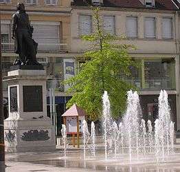
Place de la Liberté with the statue of Claude Lecourbe | ||
| ||
 Lons-le-Saunier | ||
|
Location within Bourgogne-Franche-Comté region  Lons-le-Saunier | ||
| Coordinates: 46°40′31″N 5°33′16″E / 46.6753°N 5.5544°ECoordinates: 46°40′31″N 5°33′16″E / 46.6753°N 5.5544°E | ||
| Country | France | |
| Region | Bourgogne-Franche-Comté | |
| Department | Jura | |
| Arrondissement | Lons-le-Saunier | |
| Canton | Lons-le-Saunier-Nord and Lons-le-Saunier-Sud | |
| Intercommunality | Bassin de Lons-le-Saunier | |
| Government | ||
| • Mayor (2014–2020) | Jacques Pélissard | |
| Area1 | 7.68 km2 (2.97 sq mi) | |
| Population (2012)2 | 17,353 | |
| • Density | 2,300/km2 (5,900/sq mi) | |
| Time zone | CET (UTC+1) | |
| • Summer (DST) | CEST (UTC+2) | |
| INSEE/Postal code | 39300 / 39000 | |
| Elevation |
243–415 m (797–1,362 ft) (avg. 255 m or 837 ft) | |
|
1 French Land Register data, which excludes lakes, ponds, glaciers > 1 km² (0.386 sq mi or 247 acres) and river estuaries. 2 Population without double counting: residents of multiple communes (e.g., students and military personnel) only counted once. | ||

Lons-le-Saunier (French pronunciation: [lɔ̃ lə sonje]) is a commune and capital of the Jura department in eastern France.
Geography
The town is in the heart of the Revermont region, at the foot of the first plateau of the Jura massif. The Jura escarpment extends to the east and south, while to the west lies the plain of Bresse and to the north extensive vineyards.
The River Vallière runs through the town, rising in a typical Jura blind valley not far away, at Revigny. It has been conduited since the 1960s on grounds of hygiene, since sewage outlets run into it. A small section remains in the open air near the parc des Bains, and only a single bridge (the pont de la Guiche) remains.
The town is approximately equally placed between Besançon, Dijon, Bourg-en-Bresse and Geneva, though the last of these lies on the other side of the Jura massif. It is served by the A39 autoroute, by which Dijon can be reached in about an hour and Lyon in an hour and a half. The town's railway station lies on the line from Strasbourg to Lyon.
The wine-growing region to the north of the town is particularly well known, and includes the vintages of l'Etoile, Château-Chalon and Arbois.
The Jura escarpment to the south and east is a popular tourist region, with its attractions including the lakes of Chalain, Clairvaux and Vouglans (at Lect, Jura), and mountain resorts such as Prénovel and Les Rousses.
In terms of area, Lons-le-Saunier is the second smallest prefectural town in France, after Bobigny.
Historical description
Globe description
The 1878 edition of the 'Globe Encyclopaedia of Universal Information' described Lons-le-Saunier as:[1]
- Lons-le-Saunier, the chief town of the department of Jura, France, on the Vallière, 60 miles S.E. of Dijon by rail. It is picturesquely girt by high mountains, the lower slopes of which are clad with vines. There are copper and iron foundries, and a trade in horses, cattle, grain, cheese, etc... The celebrated salt-springs yield 20,000 ctr. yearly. Pop. (1872) 9427. Lons-le-Saunier is the ancient Ledo Saliiiaritit.[1]
Population
| Historical population | ||
|---|---|---|
| Year | Pop. | ±% |
| 1793 | 6,740 | — |
| 1806 | 7,314 | +8.5% |
| 1821 | 7,796 | +6.6% |
| 1831 | 7,918 | +1.6% |
| 1841 | 8,565 | +8.2% |
| 1851 | 9,410 | +9.9% |
| 1861 | 9,862 | +4.8% |
| 1872 | 10,701 | +8.5% |
| 1881 | 12,373 | +15.6% |
| 1891 | 12,610 | +1.9% |
| 1901 | 12,935 | +2.6% |
| 1911 | 13,927 | +7.7% |
| 1921 | 13,152 | −5.6% |
| 1931 | 14,101 | +7.2% |
| 1946 | 15,568 | +10.4% |
| 1954 | 15,030 | −3.5% |
| 1962 | 15,924 | +5.9% |
| 1968 | 18,769 | +17.9% |
| 1975 | 20,942 | +11.6% |
| 1982 | 20,105 | −4.0% |
| 1990 | 19,144 | −4.8% |
| 1999 | 18,483 | −3.5% |
| 2006 | 17,879 | −3.3% |
| 2012 | 17,353 | −2.9% |
Personalities
Births
- Claude Joseph Rouget de Lisle (1760–1836), composer of La Marseillaise, the French national anthem
- Étienne Bobillier (1798–1840), mathematician
- Maurice Joly (1829–78), satirist and lawyer
- René Rémond (born 1918), historian and political economist
- Jeanne Champion (born 1931), French painter and writer
- Guy Canivet (born 1943), judge
- Jean-Claude Romand, medical imposter
- Jean-François Stévenin (born 1944), actor and filmmaker
Residents
- General Claude Lecourbe (1759–1815) studied in Lons; a statue of him stands in the central Place de la Liberté
Twin towns
Lons-le-Saunier is twinned with:
References
- 1 2 Ross, J.M. (editor) (1878). "Globe Encyclopaedia of Universal Information", Vol. IV, Edinburgh-Scotland, Thomas C. Jack, Grange Publishing Works, retrieved from Google Books 18 March 2009;
External links
- Official website (French)
Note: this article incorporates text from the 1878 edition of the Globe Encyclopaedia of Universal Information, a work in the public domain, and material translated from the French Wikipedia page on the same topic.
| Wikimedia Commons has media related to Lons-le-Saunier. |