Longniddry Bents
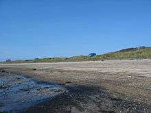
Longniddry Bents is a beach just north of Longniddry in East Lothian, Scotland.
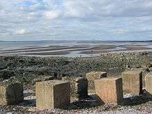
The beach is almost 2 miles in length, which includes Gosford Bayer Seton Sands to the west. Along the beach are the remains of a wall of concrete tank traps erected during World War II as protection from any attempted German invasion. Many of these are now hidden in the surrounding sea-grass and sea buckthorn bushes.
The area is popular, mostly in the summer months, with local families, holidaymakers, picnickers, horseriders, ramblers, metal detectors, dogwalkers and the occasional kite buggy. The shallow bay is a popular watersports location for windsurfers, kitesurfers and sea kayaks.
Many sea and wading birds frequent this area making it a regular haven for bird-watchers. A small community of rare water voles are known to reside around the several burns running out of the bents. Grey seals are often spotted to the west of the bay.
The area is part of the Firth of Forth Site of Special Scientific Interest, a Special Protection Area and Ramsar Site.
There are three car-parking areas here, and the largest (No. 3) has good views west across the bay to Edinburgh's skyline and the Forth Bridge and Forth Road Bridge. Overnight parking is prohibited. Edinburgh and East Coast Scotland, published as part of The Best of Britain series by Crimson Publishing, mentions "ten places to avoid" - the book describes how some picnic spots or otherwise innocent car parks can play host to dogging activities after dark, including Longniddry Bents car park.[1]
Close to car park No.3 is Gosford House, and one of its two listed 18th century lodges can be seen on the main road.
Longniddry Bents are part of the John Muir Way coastal walk and were presented with a Seaside Award (Rural) in 2006.
In the East Lothian Council-produced series of leaflets on the John Muir Way, Longniddry is included in the leaflet "Cockenzie to Aberlady". The John Muir way is also part of the North Sea Trail of seven nations and 26 areas around the North Sea.
See also
References
- ↑ "Guide book warns of gay zone and sex car park - News". Scotsman.com. 2009-05-20. Retrieved 2012-10-25.
External links
- East Lothian Council's webpage on Longniddry Bents
- City of Edinburgh page on Longniddry bents
- VisitScotland's webpage on Longniddry Bents
Coordinates: 55°58′50″N 2°54′30″W / 55.98047°N 2.90838°W