Loiret
| Loiret | |||
|---|---|---|---|
| Department | |||
|
Prefecture building of the Loiret department, in Orléans | |||
| |||
 Location of Loiret in France | |||
| Coordinates: 47°55′N 02°10′E / 47.917°N 2.167°ECoordinates: 47°55′N 02°10′E / 47.917°N 2.167°E | |||
| Country | France | ||
| Region | Centre-Val de Loire | ||
| Prefecture | Orléans | ||
| Subprefectures |
Montargis Pithiviers | ||
| Government | |||
| • President of the General Council | Eric Doligé (UMP) | ||
| Area1 | |||
| • Total | 6,775 km2 (2,616 sq mi) | ||
| Population (2013) | |||
| • Total | 665,587 | ||
| • Rank | 35th | ||
| • Density | 98/km2 (250/sq mi) | ||
| Time zone | CET (UTC+1) | ||
| • Summer (DST) | CEST (UTC+2) | ||
| Department number | 45 | ||
| Arrondissements | 3 | ||
| Cantons | 21 | ||
| Communes | 327 | ||
| ^1 French Land Register data, which exclude estuaries, and lakes, ponds, and glaciers larger than 1 km2 | |||
.jpg)

Loiret (French pronunciation: [lwaʁɛ]) is a department in north-central France.
The department is named after the river Loiret, a tributary of the Loire, and which is located wholly within the department. The capital of the department is Orléans, which is about 110 km (68 mi) southwest of Paris. As well as being the regional capital, it is a historic city on the banks of the Loire. It has a large central area with many historic buildings and mansions, and a cathedral dating back to the thirteenth century that was rebuilt after being destroyed by Protestant forces in 1568. The Loire Valley is famous for its several châteaux.
History
Loiret is one of the original 83 departments that was created during the French Revolution on March 4, 1790 by order of the National Constituent Assembly. The new departments were to be uniformly administered and approximately equal to one another in size and population. It was created from the former province of Orléanais which was too large to continue in its previous form.[1]
The Loire Valley was occupied in Palaeolithic times as attested by numerous archaeological sites in the department. The Celts were here, bringing crafts and trades, and the Romans occupied the area after the Gallic Wars. They built roads and founded cities such as Cenabum, on the site of present-day Orléans, and Sceaux-du-Gâtinais. Around 451, the Huns invaded the region but were repelled before reaching Cenabum. The Franks reached the Loire and Clovis I reigned in the area. A time of peace and prosperity ensued during the reign of Charlemagne.[2]
Geography
The department of Loiret was historically in the province of Orléans in north central France, and along with the departments of Loir-et-Cher and Eure-et-Loir now forms the region Centre-Val de Loire. To the north of Loiret lie the departments of Eure-et-Loir, Essonne and Seine-et-Marne, to the east lies Yonne, to the southeast Nièvre, to the south Cher, and to the west Loir-et-Cher.[3]
The department consists of mostly flat low-lying land through which flows the River Loire. This river enters the department near Châtillon-sur-Loire in the southeast, flows northwestwards to Orleans where it turns to flow south west, leaving the department near Beaugency.[3] The Canal d'Orléans connects the Loire River at Orléans to a junction with the Canal du Loing and the Canal de Briare in the village of Buges near Montargis. The River Loire and these canals formed important trading routes before the arrival of the railways.[4] The River Loiret, after which the department is named, is 12 km (7 mi) long and joins the Loire southwest of Orléans. Its source is at Orléans-la-Source, and its mouth at Saint-Hilaire-Saint-Mesmin. Other rivers in the department, are the River Loing, a right-bank tributary of the Loire, and the River Ouanne which flows into the Loing.[3]
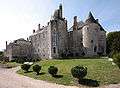
The department has a total area of 6,757 km2 (2,609 sq mi) and is 119 km (74 mi) from west to east and 77 km (48 mi) from north to south. Large parts of the land are used for agriculture, and these are separated by low wooded hills and some forested areas.[5] The northwestern part of the department is in the wheat-growing region known as Beauce, an undulating plateau with some of France's best agricultural land.[6] This area was popular with the French aristocracy in the Middle Ages and the Renaissance period, and there are many historic châteaux in the department including Château d'Augerville, Château de Bellegarde, Château de Gien, Château du Hallier, Château de Meung-sur-Loire, Château de Sully-sur-Loire and Château de Trousse-Barrière.[7]
The part of the department south of the River Loire is known as the Sologne and is an area of heathland and marshland, interspersed by hills where vines are grown.[5] The eastern part of the department is known as Gâtinais and was part of a province of that name. Until the beginning of the 21st century, it used to be renowned for the production of saffron, but the crop could not be mechanised, and production dwindled as the cost of production became too high.[8]
Economy
Of the 1,669,332 acres (675,555 ha) of land in the department, 975,000 acres (395,000 ha) are arable, 100,000 acres (40,000 ha) are vines, 60,000 acres (24,000 ha) are pasture, 280,000 acres (110,000 ha) are forested, 16,000 acres (6,500 ha) are plantations and orchards and 140,000 acres (57,000 ha) are unproductive moorland and heathland. The soil is in general fertile and productive; the Beauce is the main wheat-growing region, oats are widely cultivated and rye is also grown. Other crops include fruit, asparagus, saffron and herbs. Vines are cultivated and wine produced, and the area is noted for its fruit preservation. Bee-keeping also takes place and honey is produced.[5] Loiret has little industrial development, and commerce is centred about the sale of corn, timber, cattle, chestnuts, cider, honey, flour, fruits, fish, salt, saffron and wool. The only minerals extracted are stone, limestone, marl and clay.[5]
Transport
The department benefits from its proximity to Paris to which it has good transport links. Orléans does not yet have a TGV but is connected to Paris via fast express trains. The A71 autoroute links Paris with Orléans and Clermont-Ferrand,[6] the A10 autoroute links Paris with Orléans and Bordeaux, and the Route nationale 20 links Paris with Orléans, Limoges, Toulouse and Spain.
Tourism
Orléans is a popular tourist destination and is associated with Joan of Arc. The Cathedral of Sainte-Croix was built in the Gothic style between 1278 and 1329, destroyed by Protestant forces in 1568, and rebuilt between the 17th and 19th centuries.[9]


See also
- Cantons of the Loiret department
- Communes of the Loiret department
- Arrondissements of the Loiret department
References
- ↑ Schama, Simon (1989). Citizens: A Chronicle of the French Revolution. New York: Knopf.
- ↑ Haine, W. Scott (2000). The History of France. Greenwood Publishing Group. pp. 31–35. ISBN 978-0-313-30328-9.
- 1 2 3 Philips' Modern School Atlas. George Philip and Son, Ltd. 1973. pp. 42–43. ISBN 0-540-05278-7.
- ↑ Loire Nivernais Waterways Guide 02. Editions Du Breil. ISBN 2-913120-00-8.
- 1 2 3 4 Comprehensive Dictionary of the World. Mittal Publications. 1992. p. 612. GGKEY:RC6C27C4NE1.
- 1 2 "The Centre region of France". About-France.com. Retrieved 27 September 2015.
- ↑ Mesqui, Jean (1997). Chateaux-forts et fortifications en France. Paris: Flammarion. p. 493. ISBN 2-08-012271-1.
- ↑ Toussaint-Samat, Maguelonne (2009). A History of Food. John Wiley & Sons. p. 469. ISBN 978-1-4443-0514-2.
- ↑ "Sainte-Croix Cathedral". Encyclopaedia Britannica. Encyclopaedia Britannica. Retrieved 17 October 2015.
External links
| Wikimedia Commons has media related to Loiret. |
- Prefecture website (French)
- General Council website (French)
- Loiret at DMOZ (English)