Logan Township, New Jersey
| Logan Township, New Jersey | |
|---|---|
| Township | |
| Township of Logan | |
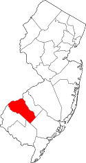
 Logan Township highlighted in Gloucester County. Inset map: Gloucester County highlighted in the State of New Jersey. | |
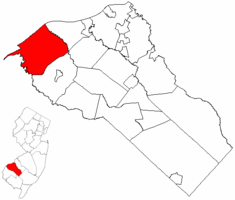
 Census Bureau map of Logan Township, New Jersey | |
| Coordinates: 39°47′31″N 75°21′19″W / 39.792079°N 75.355179°WCoordinates: 39°47′31″N 75°21′19″W / 39.792079°N 75.355179°W[1][2] | |
| Country |
|
| State |
|
| County |
|
| Incorporated | March 7, 1877 as West Woolwich Township |
| Renamed | March 6, 1878 as Logan Township |
| Named for | John Alexander "Black Jack" Logan |
| Government[3] | |
| • Type | Faulkner Act (Small Municipality) |
| • Body | Township Council |
| • Mayor | Frank W. Minor (D, term ends December 31, 2019)[4] |
| • Administrator | Lyman Barnes[5] |
| • Clerk | Linda Oswald[5] |
| Area[1] | |
| • Total | 26.929 sq mi (69.747 km2) |
| • Land | 21.925 sq mi (56.786 km2) |
| • Water | 5.004 sq mi (12.961 km2) 18.58% |
| Area rank |
99th of 566 in state 3rd of 24 in county[1] |
| Elevation[6] | 3 ft (0.9 m) |
| Population (2010 Census)[7][8][9] | |
| • Total | 6,042 |
| • Estimate (2015)[10] | 5,983 |
| • Rank |
344th of 566 in state 15th of 24 in county[11] |
| • Density | 275.6/sq mi (106.4/km2) |
| • Density rank |
485th of 566 in state 22nd of 24 in county[11] |
| Time zone | Eastern (EST) (UTC-5) |
| • Summer (DST) | Eastern (EDT) (UTC-4) |
| ZIP code | 08085, 08014 Swedesboro[12] |
| Area code(s) | 856 exchanges: 241, 467[13] |
| FIPS code | 3401541160[1][14][15] |
| GNIS feature ID | 0882143[16] |
| Website |
www |
Logan Township is a township in Gloucester County, New Jersey, United States. As of the 2010 United States Census, the township's population was 6,042,[7][8][9] reflecting an increase of 10 (+0.2%) from the 6,032 counted in the 2000 Census, which had in turn increased by 885 (+17.2%) from the 5,147 counted in the 1990 Census.[17]
Logan Township was originally formed as West Woolwich Township by an act of the New Jersey Legislature on March 7, 1877, from portions of Woolwich Township. That name lasted just less than a year, as the name was changed to Logan Township as of March 6, 1878.[18]
The community is named for John Alexander "Black Jack" Logan, a Union Army General who was behind the establishment of Memorial Day as an American national holiday.[19][20]
Geography
According to the United States Census Bureau, the township had a total area of 26.929 square miles (69.747 km2), including 21.925 square miles (56.786 km2) of land and 5.004 square miles (12.961 km2) of water (18.58%).[1][2]
Beckett (with a 2010 Census population of 4,847[21]) is an unincorporated community and census-designated place (CDP) located within Logan Township.[22]
Other unincorporated communities, localities and place names located partially or completely within the township include Bridgeport, Cadwalader, Center Square, Cooper Wharf, Coopers, Flood Gates, New Bridge, Nortonville, Prospect, Raccoon Island and Repaupo.[19][23] It is also home to Pureland Industrial Complex, a 3,000-acre (12 km2) industrial park that is one of the largest in the nation.
The township borders Greenwich Township and Woolwich Township. Logan Township also borders the Delaware River, and Oldmans Creek serves as its border with Oldmans Township in Salem County. Raccoon Creek branches off from the Delaware River in Logan Township.
Demographics
| Historical population | |||
|---|---|---|---|
| Census | Pop. | %± | |
| 1880 | 1,765 | — | |
| 1890 | 1,523 | −13.7% | |
| 1900 | 1,444 | −5.2% | |
| 1910 | 1,523 | 5.5% | |
| 1920 | 1,510 | −0.9% | |
| 1930 | 1,860 | 23.2% | |
| 1940 | 1,630 | −12.4% | |
| 1950 | 2,222 | 36.3% | |
| 1960 | 1,924 | −13.4% | |
| 1970 | 1,840 | −4.4% | |
| 1980 | 3,078 | 67.3% | |
| 1990 | 5,147 | 67.2% | |
| 2000 | 6,032 | 17.2% | |
| 2010 | 6,042 | 0.2% | |
| Est. 2015 | 5,983 | [10][24] | −1.0% |
| Population sources: 1880-2000[25] 1880-1920[26] 1880-1890[27] 1890-1910[28] 1910-1930[29] 1930-1990[30] 2000[31][32] 2010[7][8][9] | |||
Census 2010
The 2010 United States Census counted 6,042 people, 2,087 households, and 1,634 families residing in the township. The population density was 275.6 per square mile (106.4/km2). The township contained 2,172 housing units at an average density of 99.1 per square mile (38.3/km2). The racial makeup of the township was 81.53% (4,926) White, 12.50% (755) Black or African American, 0.15% (9) Native American, 2.55% (154) Asian, 0.02% (1) Pacific Islander, 1.13% (68) from other races, and 2.14% (129) from two or more races. Hispanics or Latinos of any race were 3.97% (240) of the population.[7]
Out of a total of 2,087 households, 40.2% had children under the age of 18 living with them, 62.6% were married couples living together, 11.5% had a female householder with no husband present, and 21.7% were non-families. 17.4% of all households were made up of individuals, and 4.7% had someone living alone who was 65 years of age or older. The average household size was 2.89 and the average family size was 3.29.[7]
In the township, 27.1% of the population were under the age of 18, 8.3% from 18 to 24, 27.6% from 25 to 44, 30.3% from 45 to 64, and 6.8% who were 65 years of age or older. The median age was 36.8 years. For every 100 females the census counted 96.7 males, but for 100 females at least 18 years old, it was 92.6 males.[7]
The Census Bureau's 2006-2010 American Community Survey showed that (in 2010 inflation-adjusted dollars) median household income was $87,209 (with a margin of error of +/- $6,583) and the median family income was $100,688 (+/- $14,321). Males had a median income of $67,192 (+/- $7,690) versus $49,914 (+/- $4,283) for females. The per capita income for the borough was $35,587 (+/- $2,882). About 1.6% of families and 3.7% of the population were below the poverty line, including 2.4% of those under age 18 and 0.0% of those age 65 or over.[33]
Census 2000
As of the 2000 United States Census[14] there were 6,032 people, 2,001 households, and 1,610 families residing in the township. The population density was 266.7 people per square mile (103.0/km²). There were 2,077 housing units at an average density of 91.8 per square mile (35.5/km²). The racial makeup of the township was 82.00% White, 13.51% African American, 0.13% Native American, 1.77% Asian, 0.02% Pacific Islander, 1.21% from other races, and 1.36% from two or more races. Hispanic or Latino of any race were 2.74% of the population.[31][32]
There were 2,001 households out of which 48.1% had children under the age of 18 living with them, 66.3% were married couples living together, 10.1% had a female householder with no husband present, and 19.5% were non-families. 15.7% of all households were made up of individuals and 4.3% had someone living alone who was 65 years of age or older. The average household size was 3.00 and the average family size was 3.38.[31][32]
In the township the population was spread out with 32.1% under the age of 18, 6.0% from 18 to 24, 35.4% from 25 to 44, 20.3% from 45 to 64, and 6.2% who were 65 years of age or older. The median age was 34 years. For every 100 females there were 97.3 males. For every 100 females age 18 and over, there were 93.5 males.[31][32]
The median income for a household in the township was $67,148, and the median income for a family was $70,771. Males had a median income of $48,415 versus $34,864 for females. The per capita income for the township was $26,853. About 3.0% of families and 4.3% of the population were below the poverty line, including 5.3% of those under age 18 and 1.0% of those age 65 or over.[31][32]
Economy
Pureland Industrial Complex was established in the early 1970s when 45 farms comprising 3,200 acres (1,300 ha) were assembled in Logan Township. Under the ownership of State Mutual Life Assurance Company of America, environmental studies were under taken by Dr. Jack McCormick, the first scientist with a doctorate in environmental science.
In 1973, the Pureland Association was formed and Declaration of Environmental Standards were established and recorded in Gloucester County, New Jersey. Approximately 1,200 acres were placed in an environmental reserve in perpetuity and rigid environmental controls were established, prior to the establishment of the Environmental Protection Agency or the New Jersey Department of Environmental Protection. These restrictive covenants protect property owners' value and are enforced by the Pureland Association which consist of property owners.
In 1976, the initial infrastructure was established with public water, sewer and rail servicing Pureland.
In 1977, Center Square Real Estate Development Company took over management of Pureland for State Mutual Life Assurance Company of America.
Rapid development took place over the years in a manner sensitive to the environment. .
In 2000, Center Square Real Estate Development Company purchased the undeveloped land from State Mutual and continues to manage and develop Pureland today.
Pureland consists of 12,000,000 square feet (1,100,000 m2) of space and houses in excess of 180 companies employing over 8,500 people, mostly in the arena of warehousing and distribution. Pureland is the largest Industrial Complex in the State of New Jersey.
Logan Township was the proposed location for the Crown Landing LNG Terminal, a liquefied natural gas (LNG) off-loading and processing facility to be sited along the Delaware River. The facility would have included an off-loading pier that would technically enter the waters of the State of Delaware. Delaware opposed to the project and filed a lawsuit in Federal court to stop the project from going forward on the basis that they control the waters in which part of the pier would be situated; a lawsuit the State of Delaware lost. The Federal Energy Regulatory Commission approved the Crown Landing LNG Terminal on June 15, 2006.[34] In 2009, long after the project should have been completed, Hess Energy acquired the project after BP failed to get plans approved and construction started. On January 6, 2012, Hess Energy surrendered its authorization to construct and operate the terminal. In a letter to the Federal Energy Regulatory Commission (FERC), Hess said it determined that the terminal would not be profitable, saying that "significant increases in natural gas production from North American shale resources" would affect prices and demand for natural gas.
Government
Local government
Logan Township is governed within the Faulkner Act, formally known as the Optional Municipal Charter Law, under the Small Municipality (Plan 3) form of New Jersey municipal government, enacted by direct petition as of January 1, 1984.[35] The government consists of a Mayor and a Township Council comprising four council members, with all positions elected at-large in partisan elections. A Mayor is elected directly by the voters to a four-year term of office. The Township Council members are elected to serve three-year terms on a staggered basis, with either one or two seats up for election each year.[3]
This five-member governing body is empowered to enact local ordinances, to levy municipal taxes and conduct the affairs of our community. In almost all cases, it can review and approve the actions of other Township of Logan, committees and agencies. The Mayor and Borough Council conducts all of its business during monthly meetings open to the public. All Legislative powers of the Township are exercised by the Mayor and Council. These powers can take the form of a resolution, ordinance or proclamation.
As of 2016, the Mayor of Logan Township is Democrat Frank Minor, whose term of office ends December 31, 2019. Members of the Logan Township Council are Deputy Mayor Christopher Morris (D, 2017), Stephen F. Dougherty (D, 2016), Doris Hall (D, 2016) and Bernadine E. Jackson (D, 2018).[36][37][38][39][40][41]
Mayor Minor is a member of the Mayors Against Illegal Guns Coalition,[42] a bi-partisan group with a stated goal of "making the public safer by getting illegal guns off the streets." The Coalition is co-chaired by Boston Mayor Thomas Menino and New York City Mayor Michael Bloomberg.
Federal, state and county representation
Logan Township is located in the 1st Congressional District[43] and is part of New Jersey's 3rd state legislative district.[8][44][45]
New Jersey's First Congressional District is represented by Donald Norcross (D, Camden).[46] New Jersey is represented in the United States Senate by Cory Booker (D, Newark, term ends 2021)[47] and Bob Menendez (D, Paramus, 2019).[48][49]
For the 2016–2017 session (Senate, General Assembly), the 3rd Legislative District of the New Jersey Legislature is represented in the State Senate by Stephen M. Sweeney (D, West Deptford Township) and in the General Assembly by John J. Burzichelli (D, Paulsboro) and Adam Taliaferro (D, Woolwich Township).[50] The Governor of New Jersey is Chris Christie (R, Mendham Township).[51] The Lieutenant Governor of New Jersey is Kim Guadagno (R, Monmouth Beach).[52]
Gloucester County is governed by a Board of Chosen Freeholders, whose seven members are elected at-large to three-year terms of office on a staggered basis in partisan elections, with two or three seats coming up for election each year. At a reorganization meeting held each January, the Board selects a Freeholder Director and a Deputy Freeholder Director from among its members. As of 2016, Gloucester County's Freeholders are Freeholder Director Robert M. Damminger (D, West Deptford Township; term ends December 31, 2018),[53] Deputy Freeholder Director Giuseppe "Joe" Chila (D, Woolwich Township; 2018),[54] Lyman J. Barnes (D, Logan Township; 2017),[55] Daniel Christy (D, Washington Township; 2016),[56] Frank J. DiMarco (D, Deptford Township; 2016),[57] Heather Simmons (D, Glassboro; 2017)[58] and Jim Jefferson (D, Woodbury; 2017).[59][60][61][62] Constitutional officers elected countywide are County Clerk James N. Hogan,[63] Surrogate Helene M. Reed (Monroe Township)[64] and Sheriff Carmel Morina (Greenwich Township).[65][66][61]
Politics
As of March 23, 2011, there were a total of 4,029 registered voters in Logan Township, of which 1,652 (41.0%) were registered as Democrats, 695 (17.2%) were registered as Republicans and 1,678 (41.6%) were registered as Unaffiliated. There were four voters registered to other parties.[67]
In the 2012 presidential election, Democrat Barack Obama received 59.7% of the vote (1,779 cast), ahead of Republican Mitt Romney with 38.9% (1,157 votes), and other candidates with 1.4% (42 votes), among the 2,997 ballots cast by the township's 4,214 registered voters (19 ballots were spoiled), for a turnout of 71.1%.[68][69] In the 2008 presidential election, Democrat Barack Obama received 59.3% of the vote (1,868 cast), ahead of Republican John McCain with 38.7% (1,219 votes) and other candidates with 1.4% (43 votes), among the 3,151 ballots cast by the township's 4,142 registered voters, for a turnout of 76.1%.[70] In the 2004 presidential election, Democrat John Kerry received 54.2% of the vote (1,600 ballots cast), outpolling Republican George W. Bush with 44.4% (1,311 votes) and other candidates with 0.7% (28 votes), among the 2,952 ballots cast by the township's 3,820 registered voters, for a turnout percentage of 77.3.[71]
In the 2013 gubernatorial election, Republican Chris Christie received 62.6% of the vote (1,041 cast), ahead of Democrat Barbara Buono with 35.6% (591 votes), and other candidates with 1.8% (30 votes), among the 1,703 ballots cast by the township's 4,133 registered voters (41 ballots were spoiled), for a turnout of 41.2%.[72][73] In the 2009 gubernatorial election, Democrat Jon Corzine received 49.8% of the vote (939 ballots cast), ahead of Republican Chris Christie with 39.5% (745 votes), Independent Chris Daggett with 8.6% (162 votes) and other candidates with 0.7% (13 votes), among the 1,886 ballots cast by the township's 4,103 registered voters, yielding a 46.0% turnout.[74]
Education
The Logan Township School District serves public school students in Kindergarten through twelfth grade. As of the 2011-12 school year, the district's two schools had an enrollment of 863 students and 76.6 classroom teachers (on an FTE basis), for a student–teacher ratio of 11.27:1.[75] Schools in the district (with 2011-12 enrollment data from the National Center for Education Statistics[76]) are Center Square School[77] on Peachwood Drive (grades PreK - 1; 213 students), Logan Township Elementary School[78] located on School Lane (grades 2-5; 650 students combined in grades 2-8) and Logan Middle School[79] (grades 6-8).[80]
Public school students in ninth through twelfth grades are educated at Kingsway Regional High School under a sending/receiving relationship in which tuition is paid on a per-pupil basis to the Kingsway Regional School District, which serves students in seventh through twelfth grades from East Greenwich Township, South Harrison Township, Swedesboro and Woolwich Township.[81][82] As of the 2011-12 school year, the district's two schools had an enrollment of 2,060 students and 154.0 classroom teachers (on an FTE basis), for a student–teacher ratio of 13.38:1.[83] Schools in the district (with 2011-12 enrollment data from the National Center for Education Statistics[84]) are Kingsway Regional Middle School[85] with 871 students in grades 7-8 and Kingsway Regional High School[86] with 1,189 students in grades 9-12.[87] Under a 2011 proposal, Kingsway would merge with its constituent member's K-6 districts to become a full K-12 district, with various options for including Logan Township as part of the consolidated district.[88]
Transportation
Roads and highways
The Commodore Barry Bridge is a cantilever bridge that spans the Delaware River from Chester, Pennsylvania to Bridgeport in Logan Township. Owned and operated by the Delaware River Port Authority, construction of the bridge began in 1969 and the bridge opened to traffic in February 1974.[89] The bridge is named for the American Revolutionary War hero and Philadelphia resident, John Barry.
Passing through the township are U.S. Route 130, U.S. Route 322/County Route 536, Route 324, and Interstate 295.
As of May 2010, the township had a total of 72.03 miles (115.92 km) of roadways, of which 32.76 miles (52.72 km) were maintained by the municipality, 19.01 miles (30.59 km) by Gloucester County, 18.04 miles (29.03 km) by the New Jersey Department of Transportation and 2.22 miles (3.57 km) by the New Jersey Turnpike Authority.[90]
Public transportation
New Jersey Transit bus service is available between in the township between Pennsville Township and Philadelphia on the 402 route.[91][92]
Wineries
References
- 1 2 3 4 5 2010 Census Gazetteer Files: New Jersey County Subdivisions, United States Census Bureau. Accessed May 21, 2015.
- 1 2 US Gazetteer files: 2010, 2000, and 1990, United States Census Bureau. Accessed September 4, 2014.
- 1 2 2012 New Jersey Legislative District Data Book, Rutgers University Edward J. Bloustein School of Planning and Public Policy, March 2013, p. 19.
- ↑ 2016 New Jersey Mayors Directory, New Jersey Department of Community Affairs. Accessed June 14, 2016.
- 1 2 Departments, Logan Township. Accessed July 5, 2016.
- ↑ U.S. Geological Survey Geographic Names Information System: Township of Logan, Geographic Names Information System. Accessed March 7, 2013.
- 1 2 3 4 5 6 DP-1 - Profile of General Population and Housing Characteristics: 2010 for Logan township, Gloucester County, New Jersey, United States Census Bureau. Accessed November 7, 2012.
- 1 2 3 4 Municipalities Grouped by 2011-2020 Legislative Districts, New Jersey Department of State, p. 2. Accessed January 6, 2013.
- 1 2 3 Profile of General Demographic Characteristics: 2010 for Logan township, New Jersey Department of Labor and Workforce Development. Accessed November 7, 2012.
- 1 2 PEPANNRES - Annual Estimates of the Resident Population: April 1, 2010 to July 1, 2015 - 2015 Population Estimates for New Jersey municipalities, United States Census Bureau. Accessed May 22, 2016.
- 1 2 GCT-PH1 Population, Housing Units, Area, and Density: 2010 - State -- County Subdivision from the 2010 Census Summary File 1 for New Jersey, United States Census Bureau. Accessed November 7, 2012.
- ↑ Look Up a ZIP Code for Logan, NJ, United States Postal Service. Accessed November 7, 2012.
- ↑ Area Code Lookup - NPA NXX for Logan Township, NJ, Area-Codes.com. Accessed September 29, 2014.
- 1 2 American FactFinder, United States Census Bureau. Accessed September 4, 2014.
- ↑ A Cure for the Common Codes: New Jersey, Missouri Census Data Center. Accessed October 28, 2012.
- ↑ US Board on Geographic Names, United States Geological Survey. Accessed September 4, 2014.
- ↑ Table 7. Population for the Counties and Municipalities in New Jersey: 1990, 2000 and 2010, New Jersey Department of Labor and Workforce Development, February 2011. Accessed November 7, 2012.
- ↑ Snyder, John P. The Story of New Jersey's Civil Boundaries: 1606-1968, Bureau of Geology and Topography; Trenton, New Jersey; 1969. p. 140. Accessed October 28, 2012.
- 1 2 About Us Logan Township. Accessed November 7, 2012. "The town's name comes from Alexander 'Black Jack' Logan, an American General and founder of Memorial Day."
- ↑ Hutchinson, Viola L. The Origin of New Jersey Place Names, New Jersey Public Library Commission, May 1945. Accessed September 3, 2015.
- ↑ DP-1 - Profile of General Population and Housing Characteristics: 2010 Demographic Profile Data for Beckett CDP, New Jersey, United States Census Bureau. Accessed November 7, 2012.
- ↑ New Jersey: 2010 - Population and Housing Unit Counts - 2010 Census of Population and Housing (CPH-2-32), United States Census Bureau, August 2012. Accessed November 10, 2012.
- ↑ Locality Search, State of New Jersey. Accessed May 21, 2015.
- ↑ Census Estimates for New Jersey April 1, 2010 to July 1, 2015, United States Census Bureau. Accessed May 22, 2016.
- ↑ Barnett, Bob. "Population Data for Gloucester County Municipalities, 1800 - 2000, WestJersey.org, January 6, 2011. Accessed November 7, 2012.
- ↑ Compendium of censuses 1726-1905: together with the tabulated returns of 1905, New Jersey Department of State, 1906. Accessed October 20, 2013.
- ↑ Porter, Robert Percival. Preliminary Results as Contained in the Eleventh Census Bulletins: Volume III - 51 to 75, p. 97. United States Census Bureau, 1890. Accessed October 20, 2013.
- ↑ Thirteenth Census of the United States, 1910: Population by Counties and Minor Civil Divisions, 1910, 1900, 1890, United States Census Bureau, p. 336. Accessed November 7, 2012.
- ↑ Fifteenth Census of the United States : 1930 - Population Volume I, United States Census Bureau, p. 716. Accessed November 7, 2012.
- ↑ Table 6. New Jersey Resident Population by Municipality: 1930 - 1990, New Jersey Department of Labor and Workforce Development. Accessed June 28, 2015.
- 1 2 3 4 5 Census 2000 Profiles of Demographic / Social / Economic / Housing Characteristics for Logan township, Gloucester County, New Jersey, United States Census Bureau. Accessed November 7, 2012.
- 1 2 3 4 5 DP-1: Profile of General Demographic Characteristics: 2000 - Census 2000 Summary File 1 (SF 1) 100-Percent Data for Logan township, Gloucester County, New Jersey, United States Census Bureau. Accessed November 7, 2012.
- ↑ DP03: Selected Economic Characteristics from the 2006-2010 American Community Survey 5-Year Estimates for Logan township, Gloucester County, New Jersey, United States Census Bureau. Accessed November 7, 2012.
- ↑ Commission authorizes three new LNG import terminals, expansions of two other LNG import facilities, Federal Energy Regulatory Commission press release dated June 15, 2006.
- ↑ "The Faulkner Act: New Jersey's Optional Municipal Charter Law", New Jersey State League of Municipalities, July 2007. Accessed October 20, 2013.
- ↑ Elected Officials, Logan Township. Accessed July 5, 2016.
- ↑ 2015 Municipal Data Sheet, Logan Township. Accessed July 5, 2016.
- ↑ Gloucester County 2016 Official Directory, Gloucester County, New Jersey. Accessed July 5, 2016.
- ↑ General Election November 3, 2015 Unofficial Results, Gloucester County, New Jersey Clerk, updated November 9, 2015. Accessed July 5, 2016.
- ↑ 2014 General Election Unofficial Results, Gloucester County, New Jersey Clerk, updated November 13, 2014. Accessed July 5, 2016.
- ↑ 2013 General Election November 5, 2013 Summary Report Gloucester County, Gloucester County, New Jersey Clerk, updated March 10, 2014. Accessed July 5, 2016.
- ↑ "Mayors Against Illegal Guns: Coalition Members".
- ↑ Plan Components Report, New Jersey Redistricting Commission, December 23, 2011. Accessed January 6, 2013.
- ↑ 2016 New Jersey Citizen's Guide to Government, p. 60, New Jersey League of Women Voters. Accessed July 20, 2016.
- ↑ Districts by Number for 2011-2020, New Jersey Legislature. Accessed January 6, 2013.
- ↑ Directory of Representatives: New Jersey, United States House of Representatives. Accessed January 5, 2012.
- ↑ About Cory Booker, United States Senate. Accessed January 26, 2015. "He now owns a home and lives in Newark's Central Ward community."
- ↑ Biography of Bob Menendez, United States Senate, January 26, 2015. "He currently lives in Paramus and has two children, Alicia and Robert."
- ↑ Senators of the 114th Congress from New Jersey. United States Senate. Accessed January 26, 2015. "Booker, Cory A. - (D - NJ) Class II; Menendez, Robert - (D - NJ) Class I"
- ↑ Legislative Roster 2016-2017 Session, New Jersey Legislature. Accessed January 17, 2016.
- ↑ "About the Governor". State of New Jersey. Retrieved 2010-01-21.
- ↑ "About the Lieutenant Governor". State of New Jersey. Retrieved 2010-01-21.
- ↑ Robert M. Damminger, Gloucester County, New Jersey. Accessed February 3, 2016.
- ↑ Giuseppe (Joe) Chila, Gloucester County, New Jersey. Accessed February 3, 2016.
- ↑ Lyman Barnes, Gloucester County, New Jersey. Accessed February 3, 2016.
- ↑ Daniel Christy, Gloucester County, New Jersey. Accessed February 3, 2016.
- ↑ Frank J. DiMarco, Gloucester County, New Jersey. Accessed February 3, 2016.
- ↑ Heather Simmons, Gloucester County, New Jersey. Accessed February 3, 2016.
- ↑ Jim Jefferson, Gloucester County, New Jersey. Accessed February 3, 2016.
- ↑ Board of Freeholders, Gloucester County, New Jersey. Accessed February 3, 2016.
- 1 2 2014 Gloucester County Official Directory, Gloucester County, New Jersey. Accessed September 12, 2014.
- ↑ 2014 County Data Sheet, Gloucester County, New Jersey. Accessed September 12, 2014.
- ↑ James N. Hogan, Gloucester County, New Jersey. Accessed February 3, 2016.
- ↑ Surrogate Helene M. Reed, Gloucester County, New Jersey. Accessed February 3, 2016.
- ↑ Sheriff Carmel M. Morina, Gloucester County, New Jersey. Accessed February 3, 2016.
- ↑ Row Officers, Gloucester County, New Jersey. Accessed February 3, 2016.
- ↑ Voter Registration Summary - Gloucester, New Jersey Department of State Division of Elections, March 23, 2011. Accessed November 7, 2012.
- ↑ "Presidential General Election Results - November 6, 2012 - Gloucester County" (PDF). New Jersey Department of Elections. March 15, 2013. Retrieved December 24, 2014.
- ↑ "Number of Registered Voters and Ballots Cast - November 6, 2012 - General Election Results - Gloucester County" (PDF). New Jersey Department of Elections. March 15, 2013. Retrieved December 24, 2014.
- ↑ 2008 Presidential General Election Results: Gloucester County, New Jersey Department of State Division of Elections, December 23, 2008. Accessed November 7, 2012.
- ↑ 2004 Presidential Election: Gloucester County, New Jersey Department of State Division of Elections, December 13, 2004. Accessed November 7, 2012.
- ↑ "Governor - Gloucester County" (PDF). New Jersey Department of Elections. January 29, 2014. Retrieved December 24, 2014.
- ↑ "Number of Registered Voters and Ballots Cast - November 5, 2013 - General Election Results - Gloucester County" (PDF). New Jersey Department of Elections. January 29, 2014. Retrieved December 24, 2014.
- ↑ 2009 Governor: Gloucester County, New Jersey Department of State Division of Elections, December 31, 2009. Accessed November 7, 2012.
- ↑ District information for Logan Township School District, National Center for Education Statistics. Accessed December 29, 2014.
- ↑ School Data for the Logan Township School Districts, National Center for Education Statistics. Accessed December 29, 2014.
- ↑ Center Square School, Logan Township School District. Accessed October 20, 2013.
- ↑ Logan Township Elementary School, Logan Township School District. Accessed October 20, 2013.
- ↑ Logan Middle School, Logan Township School District. Accessed December 29, 2014.
- ↑ New Jersey School Directory for the Logan Township School District, New Jersey Department of Education. Accessed October 19, 2013.
- ↑ Kingsway Regional School District 2015 Report Card Narrative, New Jersey Department of Education. Accessed May 27, 2016. "Kingsway is situated in a predominately rural/suburban area, with more than 20,000 people residing within its 52 square mile border. The District includes the Borough of Swedesboro and the Townships of South Harrison, East Greenwich, and Woolwich. Though not part of the District, students from Logan Township attend Kingsway High School through a send/receive relationship as paid tuition students."
- ↑ School Profile, Kingsway Regional School District. Accessed December 9, 2014. "The District includes Swedesboro and the Townships of South Harrison, East Greenwich and Woolwich. Though not part of the District, students from Logan Township attend Kingsway High School through a send/receive relationship as paid tuition students."
- ↑ District information for Kingsway Regional School District, National Center for Education Statistics. Accessed December 9, 2014.
- ↑ School Data for the Kingsway Regional School District, National Center for Education Statistics. Accessed December 9, 2014.
- ↑ Kingsway Regional Middle School, Kingsway Regional School District. Accessed December 9, 2014.
- ↑ Kingsway Regional Middle School, Kingsway Regional School District. Accessed December 9, 2014.
- ↑ New Jersey School Directory for the Kingsway Regional School District, New Jersey Department of Education. Accessed December 9, 2014.
- ↑ Forand, Rebecca. "Kingsway districts may see change", Gloucester County Times, April 7, 2011. Accessed December 9, 2014. "A study is being planned to evaluate the fiscal feasibility of the regionalization of the school districts associated with the Kingsway Regional district, and the impact of continuing or severing the current relationship the district has with Logan Township. Woolwich township, Swedesboro, East Greenwich Township and South Harrison Township all currently feed their elementary students to the Kingsway Regional district for middle and high school, with Logan Township sending students to the high school on a tuition basis. The study will address the fiscal feasibility of regionalizing Kingsway, East Greenwich, South Harrison and Swedesboro-Woolwich."
- ↑ Commodore Barry Bridge , Delaware River Port Authority. Accessed October 20, 2013.
- ↑ Gloucester County Mileage by Municipality and Jurisdiction, New Jersey Department of Transportation, May 2010. Accessed July 18, 2014.
- ↑ Gloucester County Bus / Rail Connections, New Jersey Transit, backed up by the Internet Archive as of July 26, 2010. Accessed November 7, 2012.
- ↑ South Jersey Transit Guide, Cross County Connection, as of April 1, 2010. Accessed September 29, 2014.
External links
- Official Logan Township Website
- Logan Township School District
- Logan Township School District's 2014–15 School Report Card from the New Jersey Department of Education
- School Data for the Logan Township School Districts, National Center for Education Statistics
- Kingsway Regional School District