Loenen
For other uses, see Loenen (disambiguation).
| Loenen | |||
|---|---|---|---|
| Former municipality | |||
|
| |||
| |||
 | |||
| Coordinates: 52°13′N 5°1′E / 52.217°N 5.017°ECoordinates: 52°13′N 5°1′E / 52.217°N 5.017°E | |||
| Country | Netherlands | ||
| Province | Utrecht | ||
| Municipality | Stichtse Vecht | ||
| Area(2006) | |||
| • Total | 27.32 km2 (10.55 sq mi) | ||
| • Land | 25.00 km2 (9.65 sq mi) | ||
| • Water | 2.32 km2 (0.90 sq mi) | ||
| Population (1 January 2007) | |||
| • Total | 8,222 | ||
| • Density | 329/km2 (850/sq mi) | ||
| Source: CBS, Statline. | |||
| Time zone | CET (UTC+1) | ||
| • Summer (DST) | CEST (UTC+2) | ||
| Website | www.loenen.nl | ||


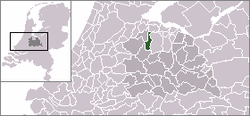
Loenen (![]() pronunciation ) is a former municipality in the Netherlands, in the province of Utrecht. It was in the Vechtstreek area. On January 1, 2011, Loenen merged with Breukelen and Maarssen to form Stichtse Vecht.
pronunciation ) is a former municipality in the Netherlands, in the province of Utrecht. It was in the Vechtstreek area. On January 1, 2011, Loenen merged with Breukelen and Maarssen to form Stichtse Vecht.
Population centres
The former municipality of Loenen consisted of the following cities, towns, villages and districts:
- Loenen (aan de Vecht) (main town)
- Loenersloot
- Mijnden
- Nieuwerhoek
- Nieuwersluis
- Nigtevecht
- Vreeland
History
The earliest traceable mention of the game of golf refers to a game played in Loenen aan de Vecht. In his book Early Golf, Steven van Hengel describes how the game of "Colf" or "Kolf" was played in 1297 near the castle of Kronenburg. The players had to hit the castle door in as few strikes as possible from the Court House by hitting a ball with a stick.
External links
This article is issued from Wikipedia - version of the 9/14/2016. The text is available under the Creative Commons Attribution/Share Alike but additional terms may apply for the media files.