Loch Shurrery
| Loch Shurrery | |
|---|---|
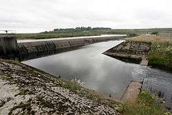 Dam at the head of Loch Shurrery | |
| Location | Caithness, Highlands Scotland |
| Coordinates | 58°28′39″N 3°38′24″W / 58.477600°N 3.640100°WCoordinates: 58°28′39″N 3°38′24″W / 58.477600°N 3.640100°W[1] |
| Type | freshwater loch |
| Primary inflows | Torran Water[2] |
| Primary outflows | Forss Water[2] |
| Basin countries | Scotland |
| Max. length | 1.25 mi (2.01 km)[3] |
| Max. width | 0.5 mi (0.80 km)[3] |
| Surface area | 99.4 ha (246 acres)[1] |
| Average depth | 4.5 ft (1.4 m)[3] |
| Max. depth | 7 ft (2.1 m)[3] |
| Water volume | 43,000,000 cu ft (1,200,000 m3)[3] |
| Shore length1 | 7.4 km (4.6 mi)[1] |
| Surface elevation | 94 m (308 ft)[1] |
| Islands | 1[1] |
| 1 Shore length is not a well-defined measure. | |
Loch Shurrery (also known as Loch Shurrey) is a small, shallow, lowland freshwater loch lying approximately 8 mi (13 km) south west of Thurso in the Scottish Highlands. The loch has a somewhat elliptical shape with a perimeter of 7.4 km (4.6 mi). It is approximately 1.25 mi (2.01 km) long, has an average depth of 4.5 ft (1.4 m) and is 7 ft (2.1 m) at its deepest. The loch was surveyed[3] on 6 October 1902 by John Parsons and T.R.H. Garrett and later charted[4] as part of Sir John Murray's Bathymetrical Survey of Fresh-Water Lochs of Scotland 1897-1909. A dam lies to the north end of the loch.
Approximately 200 yards (180 m) from the northern end of the loch are the archaeological remains of an Iron Age hut circle with a medium-sized oval house. Some pottery was found at the site.[5] At the southern end of the loch is Lambsdale Leans, a cairn with possible cist or chamber. Two Viking graves lie nearby.[6]
The loch is used for fishing and the Dounreay Fly Fishing Association keeps a boat on the loch for members and visitors.[7]
References
- 1 2 3 4 5 "Loch Shurrey". British lakes. British Lakes. Retrieved 18 June 2016.
- 1 2 "Sheet 11 - Thurso & Reay". National Library of Scotland. Ordnance Survey. 1931. Retrieved 18 June 2016.
- 1 2 3 4 5 6 "Bathymetrical Survey of the Fresh-Water Lochs of Scotland, 1897-1909, Lochs of the Forss Basin". National Library of Scotland. Retrieved 18 June 2016.
- ↑ "Loch Calder; Loch Shurrery (Vol. 5, Plate 7), Bathymetrical Survey, 1897-1909". National Library of Scotland. Retrieved 12 June 2016.
- ↑ MacLaren, Alistair (1955). "Later Prehistoric house and Early Medieval buildings in Northern Scotland: Excavations at Loch Shurrery and Lambsdale Leans, Caithness, 1955" (PDF). Archaeology Data Service. Retrieved 2016-06-18.
- ↑ "Lambsdale". Canmore. Retrieved 2016-06-18.
- ↑ "Loch Shurrery". Dounreay Fly Fishing Association.