Loch Leven (Highlands)
Loch Leven (Scottish Gaelic: Loch Liobhann)[1] 'is a sea loch on the west coast of Scotland. It is spelled Loch Lyon in Timothy Pont's map of the area[2] and is pronounced Li' un. The local Gaelic pronunciation is Lee' oon[3]
_Loch_Leven.png)

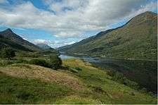
Loch Leven extends 8 3⁄4 miles (14.1 km), varying in width between 220 yards (200 m) and just over 1 mile (1.6 km). It opens onto Camus a' Chois at North Ballachulish, part of Loch Linnhe at its western end. There are nine small islands, some rocky and covered with heather and some just smooth green grass, near the western end of the loch.
The village of Glencoe (Scottish Gaelic: A' Charnaich)[4] lies on its southern shore. The burial place of the MacDonald clan of Glencoe lies on an island - Eilean Munde, St.Munda's or St Munn's or Saint Fintan Munnu's Island, opposite the village. The island burial place was also shared by the Camerons of Callart, on the north shore of the loch, the Stewarts of Ballachulish and Appin and other local families.[5]
The village of Kinlochleven at the head of the loch was established when the aluminium smelter was built there during the first decade of the twentieth century. It was originally the hamlets of Kinlochmore (Inverness-shire) and Kinlochbeg (Argyll) either side of the River Leven. It lies on the road north to Fort William (Scottish Gaelic: An Gearasdan Inbhir-Lochaidh,[6] built in 1927, which followed the shores of the loch, but a bridge was built across the mouth of the loch at Ballachulish in 1975 to replace the Ballachulish Ferry.
Under the Ballachulish Bridge, at the entrance to the loch, is the narrows Caolas Mhic Phàdraig. The settlements either side are North and South Ballachulish - Baile a' Chaolais (the settlement on the narrows). There is a fast tidal stream through the narrows, running at up to seven knots at springs; it is wise, therefore, to time any passage through the narrows with the tides. Further up the loch, there are several other narrows - principally Caolas na Con - with significant, but diminishing tidal streams. The loch is navigable as far as Kinlochleven, and was used by ships bringing alumina to the smelter there until its closure.
Coordinates: 56°41′26″N 5°7′6″W / 56.69056°N 5.11833°W
References
| Wikimedia Commons has media related to Loch Leven (Highlands). |
- ↑ Map of Alba, Roy Pederson, 26 Glenburn Drive, Inverness (1985)
- ↑ Pont 13: National Library of Scotland
- ↑ A Pronouncing Dictionary of Scottish Gaelic by Henry Cyril Dieckhoff, Gairm Publications, 29 Waterloo Street, Glasgow G2 6BZ (1992)
- ↑ Ainmean-Aite na h-Alba - A82 place-name list; Tron Bhogha-Froise - Sgeulachdan is Bardachd, Alasdair MacAonghais, Canan, Sabhal Mor Ostaig, An Teangha, Sleite, An t-Eilean Sgitheanach, (1999)
- ↑ Tombstone Inscriptions on the Burial Isle of St. Munda (Eilean Munde) on Loch Leven recorded by Alexander MacDonald, 2002 and 2003, for the Glencoe Heritage Trust Ltd.
- ↑ Dwelly's Illustrated Gaelic to English Dictionary by Edward Dwelly, Gairm Publications, 29 Waterloo Street, Glasgow G2 6BZ (1988)