Loch Achall
| Loch Achall | |
|---|---|
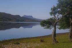 A view towards the east end of the loch from Stacan Dubha. | |
| Location | Ullapool, Ross and Cromarty, Scotland |
| Coordinates | 57°54′29.83″N 5°4′56.18″W / 57.9082861°N 5.0822722°W |
| Primary outflows | River Ullapool |
| Basin countries | Scotland |
| Max. length | 3.0 km (1.9 mi) |
| Surface area | 3.36 km2 (1.30 sq mi) |
| Average depth | 27.7 ft (8.4 m) |
| Max. depth | 70 ft (21 m) |
| Water volume | 11.4 km3 (2.7 cu mi) |
| Surface elevation | 262.4 ft (80.0 m) |
Loch Achall (Gaelic: Loch Ach a' Challa - loch of the hazel field) is a freshwater loch, lying 2 miles northeast of Ullapool, in Rhidorroch, Ross and Cromarty, Scotland.[1]
Geography
Loch Achall is a long narrow loch, 0.579 km (0.360 mi) at its widest point. It is dominated by the peaks of the Marilyn's Beinn Eilideach directly to the south, at 1,833 ft (559 m) and the peak of Meall Liath Choire to the north east at 1,801 ft (549 m). The loch is fed by the Rivers Rhidorroch and Allt a'Ghiubhais, while the River Ullapool flows from its western end towards Loch Broom.
References
- ↑ Achall, Loch
This article is issued from Wikipedia - version of the 8/27/2015. The text is available under the Creative Commons Attribution/Share Alike but additional terms may apply for the media files.