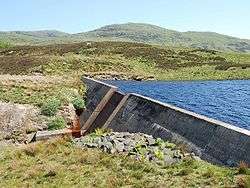
Loch A' Chaorainn
National grid reference NR77787535
| Loch A' Chaorainn | |
|---|---|
 | |
| Location | South Knapdale, Scotland |
| Coordinates | 55°55′09″N 5°33′30″W / 55.9193°N 5.5582°WCoordinates: 55°55′09″N 5°33′30″W / 55.9193°N 5.5582°W |
| Type | Reservoir |
| Basin countries | Scotland, United Kingdom |
| Surface area | 123,200 sq. metres |
| Water volume | 305,000 cubic metres |
| Surface elevation | 155 metres |
Loch A' Chaorainn (Loch of the Rowan) is an impounding reservoir which lies 9 kilometres north west of Tarbert. The concrete dam is 8.2 metres high and was completed in 1995.
See also
Sources
This article is issued from Wikipedia - version of the 10/7/2012. The text is available under the Creative Commons Attribution/Share Alike but additional terms may apply for the media files.